A major hurricane force storm continues over the western North Pacific with winds up to 65 knots and significant wave heights up to 20 meters (about 66 feet)! The significant wave height is the average of the 1/3 highest waves which means that some waves will be higher. Given a significant wave of 20 meters, about 1 in 10 waves could be 25 meters (82 feet) and 1 out of 100 could be as high as 33 meters (108 feet)!
Previously reported on 15 January:
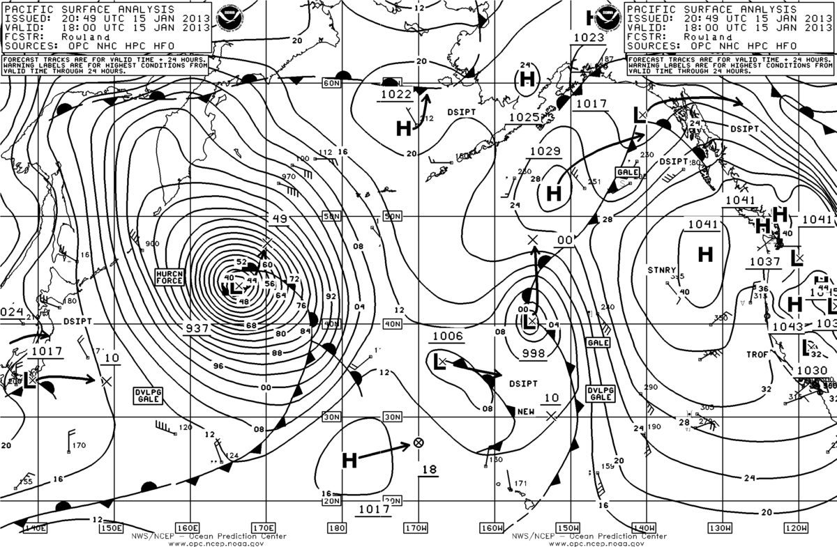
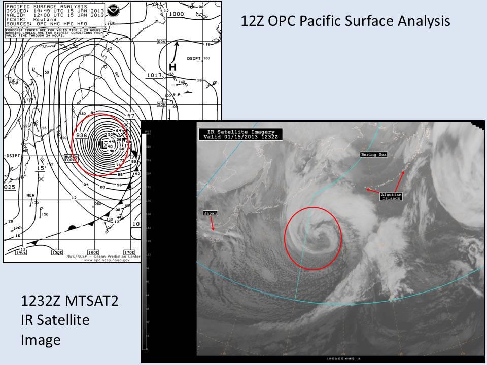
A very dangerous 936 mb storm peaked today over the western North Pacific with a min pressure of 932 mb and is moving northeast at 25 knots with hurricane force winds and very high sea and swell conditions. Hurricane Sandy, by comparison, reached a minimum pressure of 940 millibars and was the largest Atlantic hurricane in recorded history.
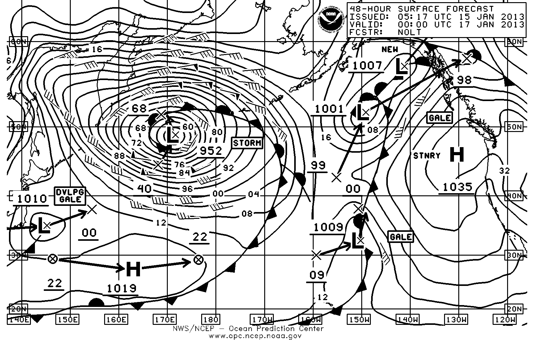
At 12Z 15 January the center of the storm was near 42N/163E with winds of Force 11 or higher (60-85 knots) and waves 12-18 meters (39-59 feet) within 300NM west and southwest of the center and winds forces 9-11 and waves 5.5-14 meters (18-46 feet) up to 540NM from the center.
This storm and will now weaken slowly as it moves northeastward.
Keep in mind that the wave heights here are the significant wave height which is defined as the average of the 1/3 highest waves. This means that some individual waves could be up to twice the significant wave height!
This storm appears to be an example of a rapidly deepening “bomb” low that is often associated with some winter season storms over both the North Atlantic and North Pacific oceans. These systems are associated with what is known as a warm air seclusion where the warm surface air is lifted up during the occlusion process and then wrapped around the low center into its cold southwestern quadrant.
932 millibars!
Gale force winds are predicted to extend from 36N to 60N, over 1,400 nautical mile wide swath of ocean.
A strengthening El Niño is on track to become one of the strongest events in the historical record, raising fresh concerns for global shipping just days after the Panama Canal...
The United States is ramping up efforts to secure domestic sources of critical minerals with a major new seabed mapping initiative in the Pacific, part of a broader push to...
NOAA Ocean Exploration and Fugro have signed a cooperative research and development agreement (CRADA) focused on advancing uncrewed systems for deep ocean mapping and characterization. The partnership aims to enhance...
September 17, 2025
Total Views: 611
Get The Industry’s Go-To News
Subscribe to gCaptain Daily and stay informed with the latest global maritime and offshore news
— just like 104,486 professionals
Secure Your Spot
on the gCaptain Crew
Stay informed with the latest maritime and offshore news, delivered daily straight to your inbox
— trusted by our 104,486 members
Your Gateway to the Maritime World!
Essential news coupled with the finest maritime content sourced from across the globe.

 Join The Club