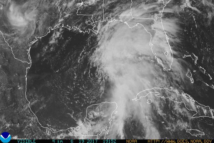
GOES visible satellite image from June 19, 2017. Image credit: NOAA
By Brian K. Sullivan (Bloomberg) — The Atlantic hurricane season is less than three weeks old yet it’s already threatening the energy-rich Gulf of Mexico coastline with flooding rains and sparking tropical storm warnings in Venezuela.
Tropical systems in the Gulf of Mexico often grab the notice of energy traders because the Texas and Louisiana coastline is home to offshore rigs and platforms accounting for about 17 percent of U.S. crude oil output and 4.1 percent of natural gas production. They can lead to the evacuation of non-essential personnel from rigs and platforms, cause power outages and also disrupt shipping.
Two potential systems are gathering strength at either end of the Caribbean Sea at a time of year when multiple storms are unusual. One is near Mexico’s Yucatan Peninsula and may slip into the Gulf of Mexico overnight. The other is off the coast of South America and bearing down on Trinidad and Tobago.
“It is unusual but not unprecedented,” said Bob Henson, a meteorologist and blogger with Weather Underground in Boulder, Colorado. “Both will affect land.”
The system near the Yucatan Peninsula has an 80 percent chance of becoming a tropical depression or storm in the next two days as it drifts into the southern Gulf of Mexico.
The biggest threat from the storm will be heavy rain along the U.S. Gulf Coast, said Dan Pydynowski, a senior meteorologist at AccuWeather Inc. in State College, Pennsylvania. There are upper level winds that could push the heaviest rain away from its center, which he said could probably come ashore anywhere from the Texas-Louisiana border to the Florida Panhandle.
Heavy Rain
No one should discount the damage these rains can do, Henson said. One forecast model predicted Monday at least 6 to 10 inches of rain could fall across a large portion of the Gulf Coast with some pockets getting as much as 20 inches.
“The last time that happened it was a major disaster,” Henson said.
The system heading toward Trinidad and Tobago was about 325 miles east-southeast with winds of 40 miles per hour. While the winds were tropical-storm strength, the system lacked the structure necessary for forecasters to name it, said Dennis Feltgen, a spokesman for the National Hurricane Center in Miami.
“This storm is unusually far south, the center may go right over Trinidad and Tobago tonight,” said Pydynowski. “There will be several inches of rainfall, wind gusts from 40 to 50 miles per hour tonight and early tomorrow.”
An aircraft is flying into the system to take a closer look.
It’s rare for a storm to threaten Trinidad, the biggest supplier of liquefied natural gas to Engie SA’s Everett import terminal in Massachusetts.
“There have only been four in the last 150 years that we know about,” Henson said. “The only hurricane that has formed was the Trinidad hurricane of 1933.”
Henson said chances are its luck will run out in the next few days. It will enter a section of the Caribbean often called the “graveyard of storms” where it will be torn apart, he said.
While it’s hard to predict what the rest of the year will bring based on early activity, these storms could be indicators of a busy Atlantic season, Henson said. An average season produces 12 named systems of at least tropical storm strength.
© 2017 Bloomberg L.P
Editorial Standards · Corrections · About gCaptain
This article contains reporting from Bloomberg, published under license.

 Join The Club