Aug 3 (Reuters) – Russia’s Ministry for Emergency Services lifted a tsunami warning for the Kamchatka Peninsula on Sunday after a 7.0 magnitude earthquake hit the nearby Kuril Islands.
The ministry had said earlier on the Telegram messaging app that expected wave heights were low, but warned people to move away from the shore.
The Pacific Tsunami Warning System, which gauged the quake at 7.0, said, however, there was no tsunami warning after the quake. The U.S. Geological Survey also said the earthquake was at a magnitude of 7.
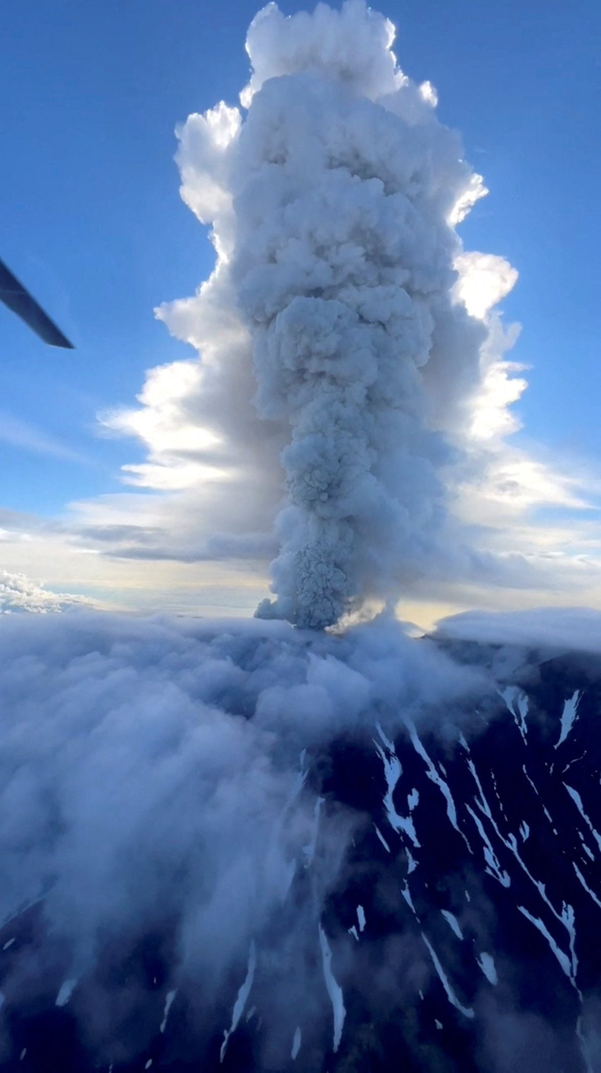
Overnight, the Krasheninnikov Volcano in Kamchatka erupted for the first time in 600 years, Russia’s RIA state news agency and scientists reported on Sunday.
Both incidents could be connected to the huge earthquake that rocked Russia’s Far East last week, that triggered tsunami warnings as far away as French Polynesia and Chile, and was followed by an eruption of Klyuchevskoy, the most active volcano on the Kamchatka Peninsula.
The Kuril Islands stretch from the southern tip of Kamchatka Peninsula. Russian scientists had warned on Wednesday that strong aftershocks were possible in the region in the next several weeks.
“This is the first historically confirmed eruption of Krasheninnikov Volcano in 600 years,” RIA cited Olga Girina, head of the Kamchatka Volcanic Eruption Response Team, as saying.
On the Telegram channel of the Institute of Volcanology and Seismology, Girina said that Krasheninnikov’s last lava effusion took place within 40 years of 1463 and no eruption has been known since.
The Kamchatka branch of Russia’s ministry for emergency services said that an ash plume rising up to 6,000 meters (3.7 miles) has been recorded following the volcano’s eruption. The volcano itself stands at 1,856 meters.
“The ash cloud has drifted eastward, toward the Pacific Ocean. There are no populated areas along its path,” the ministry said on Telegram.
The eruption of the volcano has been assigned an orange aviation code, indicating a heightened risk to aircraft, the ministry said.
(Reporting by Lidia Kelly in Melbourne; Editing by Raju Gopalakrishnan)
(c) Copyright Thomson Reuters 2025.
Editorial Standards · Corrections · About gCaptain
This article contains reporting from Reuters, published under license.

 Join The Club