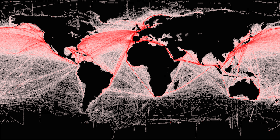
Global shipping routes crisscross the world’s oceans in this map of shipping lanes derived from a 2008 study of the human impact on marine ecosystems. Credit: Grolltech
Maritime traffic on the world’s oceans has increased four-fold over the past 20 years, according to a new study published by the American Geophysical Union quantifying global ship traffic and its impacts on the environment.
The research used satellite altimeter data to estimate the number of vessels on the ocean every year between 1992 and 2012.
According to the findings, the number of ships traversing the oceans grew by 60 percent between 1992 and 2002, and grew even faster during the second decade of the study, peaking at rate of increase of 10 percent per year in 2011.
Traffic went up in every ocean during the 20 years of the study, the report notes. In the Indian Ocean, home to some of the world’s busiest shipping lanes, ship traffic grew by more than 300 percent over the 20-year period, according to the research.
In their report, the American Geophysical Union said that the uptick in maritime traffic has likely also caused more water, air and noise pollution.
“I found it quite worrisome that the ship traffic grew so much, even in very remote regions of the world,” said Jean Tournadre, a geophysicist at Ifremer, the French Institute for the Exploitation of the Sea in Plouzane, and the study author. “Especially when we know that they are the major source of pollution [on the open ocean].”
International trade and the sizes of merchant fleets have grown rapidly over the past two decades, explaining the steep rise in ship traffic, the study reports. The new analysis has been accepted for publication in Geophysical Research Letters, a journal of the American Geophysical Union.
The study notes that burgeoning ship traffic has increased the amount of pollution in the atmosphere, particularly above the Sri Lanka-Sumatra-China shipping lane, where there has been 50 percent increase in nitrogen dioxide over the 20-year period, according to the study.
Tournadre said he hopes the new study will increase scientists’ understanding of how human activities are affecting marine ecosystems and improve models of atmospheric pollution in the open ocean.
The new dataset will provide scientists with invaluable insights into the patterns of ship traffic and the traffic’s effect on the environment, said Batuhan Osmanoglu, a radar systems engineer at NASA’s Goddard Space Flight Center in Green Belt, Md., who was not involved in the study.
“The nice thing about this study is that they have a unique dataset, that maybe we’re looking at for the first time,” he said. “Whenever you have a unique dataset you can quite easily learn something new.”
The new study is the first to track ship traffic on a global scale, Tournadre said. Currently, ship traffic is monitored using the Automatic Identification System (AIS), which tracks vessels accurately when near the coast but limited once ships are out of range on the open ocean. The new method outlined in the study used altimeters aboard satellites to detect the location of ships at sea, much like similar instruments have been used to track icebergs.
In 2007, Tournadre was poring over hordes of satellite data for signs of icebergs in polar seas, when he noticed an odd shape in the data.
“We had some unconventional data in a region, and careful analysis showed us that it was a lighthouse near shipping lanes,” he said. “As we processed the data over the whole globe, we also detected ships.”
Tournadre found that the altimetry data accurately reproduced known shipping lanes and could be used to estimate the number of vessels on the ocean worldwide. The study used altimetry data from seven different satellites to map ship traffic from 1992 to 2012.
Using satellite data made it possible to calculate ship traffic for the entire globe, whereas AIS records provide relatively limited coverage in both space and time, Tournadre said. The new method also allowed him to look back at two decades of traffic using archived data, and give independent measurements of ship traffic that were not based on the will or capability of ships to transmit their own positions.
However, Tournadre also cautions that some of the growth he has seen in ship traffic could be overestimated because ships, especially container ships, have become larger over the past two decades and possibly easier to detect with altimetry data.
Editorial Standards · Corrections · About gCaptain

 Join The Club