Satellite navigation interference detected near the United Arab Emirates coast is creating the appearance of vessels sailing in straight lines toward the Strait of Hormuz—even though the ships are not actually following those tracks—according to new analysis from vessel-tracking platform MarineTraffic.
The anomaly was first observed around 15:00 UTC off Ras Al Khaimah, UAE, where vessel positions began appearing in long linear patterns inconsistent with normal ship navigation.
“Unlike the typical single-point clustering commonly associated with signal jamming, this interference creates the appearance of vessels moving in a straight line toward the Strait of Hormuz, even though the vessels are not actually following that trajectory,” MarineTraffic said.
Playback analysis of AIS data confirms the movements are not real.
“Vessel tracks show clear inconsistencies when compared with simultaneous vessel movements and reported headings,” MarineTraffic said, noting the apparent transits are the result of satellite navigation interference rather than actual vessel activity.
Electronic Warfare Concerns Grow
The development comes as maritime security authorities warn that electronic interference affecting ship navigation systems is increasing across the Gulf region.
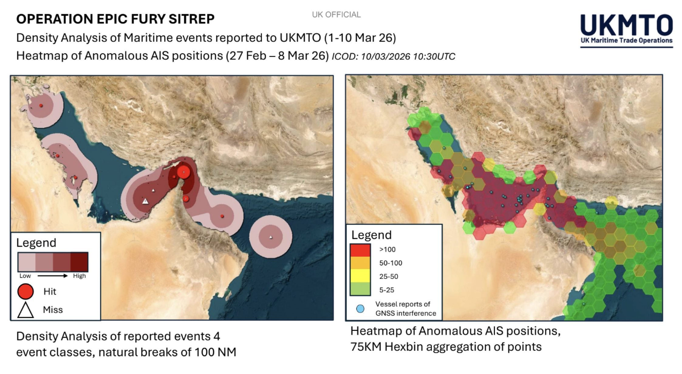
The Joint Maritime Information Center (JMIC) said in its latest advisory issued March 10 that the Strait of Hormuz and surrounding waters remain at a “critical operational risk level” for commercial shipping amid the escalating conflict with Iran. Over the past 24 hours, more than 600 GNSS disruption events have been reported across the operational area, according to aggregated open-source monitoring and maritime reporting, with documented impacts including positional offsets, AIS anomalies, and intermittent signal degradation.
A separate update from the EU’s Maritime Security Centre – Indian Ocean (MSCIO) warns that heavy GPS and AIS spoofing is continuing across the Arabian Gulf, Strait of Hormuz, and Gulf of Oman, adding that disruptions have also affected communications and radar systems.
The advisory states that navigation systems in the region are “highly likely to be unreliable”, urging vessels to rely more heavily on radar and visual navigation methods when operating in the area.
Shipping Traffic Stalls
Security conditions in the region remain highly volatile. The MSCIO advisory says military operations are ongoing across the Arabian Gulf, Gulf of Oman, North Arabian Sea and Strait of Hormuz, and warns the maritime security environment in the area has “highly deteriorated.”
Since February 28, MSCIO has recorded at least 14 incidents involving commercial vessels have been recorded, including projectile strikes on tankers and container ships, explosions near vessels, and drone-related attacks.
As a result, a large number of merchant ships are anchored, loitering, or waiting in ports across the Arabian Gulf and western Gulf of Oman, according to the advisory.
MSCIO now advises ships to avoid transiting the Strait of Hormuz until the security situation improves and to conduct enhanced voyage risk assessments before entering the region.
Data Distortion Hits Shipping Intelligence
Navigation spoofing is also complicating the work of maritime intelligence firms and energy market analysts who rely heavily on AIS data to track global shipping flows.
MarineTraffic said the spoofing pattern currently observed near the UAE coast can create the illusion of vessels entering or transiting the Strait, even when ships remain stationary or moving elsewhere.
Energy analytics firm Kpler said it has implemented enhanced monitoring protocols designed to filter out erroneous signals generated by spoofed navigation data, including false strait crossings or incorrect port calls.
Growing “Fog of Navigation”
Electronic navigation disruption has increasingly become part of modern maritime conflict environments.
Even limited GNSS spoofing can produce “phantom vessel” tracks on ship-tracking platforms, complicating situational awareness for ship operators, insurers, and maritime security authorities.
With maritime security advisories warning of a critical threat environment in the Strait of Hormuz, the emergence of spoofed navigation data highlights how electronic warfare is now directly affecting commercial shipping operations in one of the world’s most important energy corridors.
Updated: March 30, 2026 (Originally published March 10, 2026)
Editorial Standards · Corrections · About gCaptain

 Join The Club