Ever wonder how your voyage plan would look to Gerardus Mercator, John Speed or even Captain Cook? Laying out voyage plans has gotten easier in the past decade. From excel spreadsheets to nautical calculators and ECDIS programs, every Second Mate has a tool that assists him in laying out the best route to get his vessel from point A to point B. For a recent project here at gCaptain I laid out a voyage from Singapore to Europe with the exclusive use of Google Earth. This was, of course, not for navigational use but I was able to identify hazards I might not have caught on a paper chart or even an ECDIS. This got me thinking… how different would my voyage look 100 years ago using the charts and tools of the day.
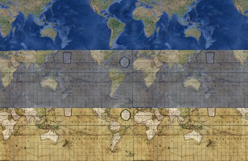
 Today’s find comes from the Google Latitude Blog and the David Rumsey Map Collection… historic chart overlays for google maps!
The above image shows small scale chart from 1790 depicting discoveries in the Pacific as well as the routes of three of Captain James Cook’s voyages. Using the overlay tool we are able to lay it over a self created google map and compare the results. While I’m still not sure the practical use for this technology it sure get’s the mind thinking.
Click Here to try it out.
Updated: February 5, 2026 (Originally published June 5, 2010)
Editorial Standards · Corrections · About gCaptain

 Join The Club