When an international team of scientists set out on an expedition to map submerged ancient landscapes in the Bulgarian waters of the Black Sea, there was no telling what exactly they would find. After all an expedition of this size and scope had never been attempted before in the area, where thousands of years ago large areas of land were inundated as the water level rose following the last Ice Age.
But perhaps the biggest finding was something absolutely nobody expected: ancient shipwrecks perfectly preserved at depths of more than 150 meters below the surface. In fact the team, led by the University of Southampton’s Centre for Maritime Archaeology, discovered a collection of more than 40 shipwrecks dating as far back as the Ottoman and Byzantine Empires, providing the first-ever views of ships from these eras and offering a glimpse into trade and seafaring life during these medieval times.
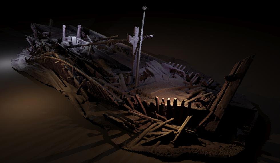
Photogrammetric model of a wreck from Ottoman period. Credit: EEF/Black Sea MAP
“The wrecks are a complete bonus, but a fascinating discovery, found during the course of our extensive geophysical surveys,” said Professor Jon Adams, Founding Director of the University of Southampton’s Centre for Maritime Archaeology and Principle Investigator on the Black Sea Maritime Archaeology Project (Black Sea MAP). “They are astonishingly preserved due to the anoxic conditions (absence of oxygen) of the Black Sea below 150 meters.”
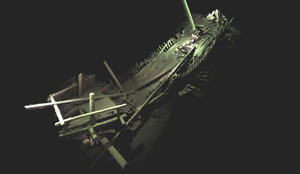
Photogrammetric model of wreck from Medieval period. Credit: EEF/Black Sea MAP
Based on board the Stril Explorer, an offshore vessel equipped with some of the most advanced underwater survey systems, the international team used two Remotely Operated Vehicles (ROVs) – one optimized for high resolution 3D photogrammetry2 and video and the other a revolutionary vehicle developed by the survey companies MMT and Reach Subsea.
“Surveyor Interceptor”, as the latter is called, ‘flies’ at four times the speed of conventional ROVs and carries an entire suite of geophysical instrumentation, as well as lights, high definition cameras and a laser scanner. In the course of the project it set new records for both depth (1,800m), sustained speed (over 6 knots), and covered a distance of 1,250 km.
“Using the latest 3D recording technique for underwater structures, we’ve been able to capture some astonishing images without disturbing the sea bed,” added Professor Adams. “We are now among the very best exponents of this practice methodology and certainly no-one has achieved models of this completeness on shipwrecks at these depths.”
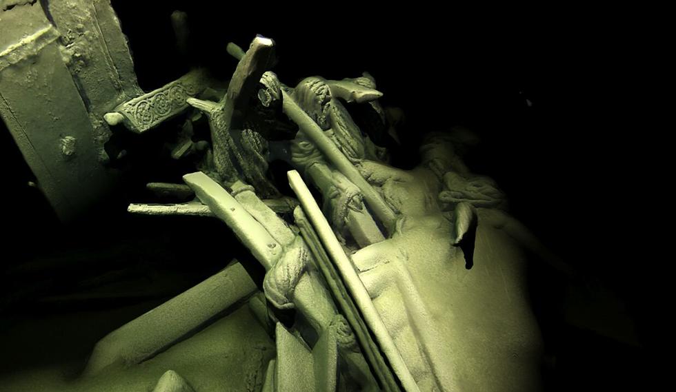
Photogrammetric model of stern of Ottoman wreck. Credit: EEF/Black Sea MAP
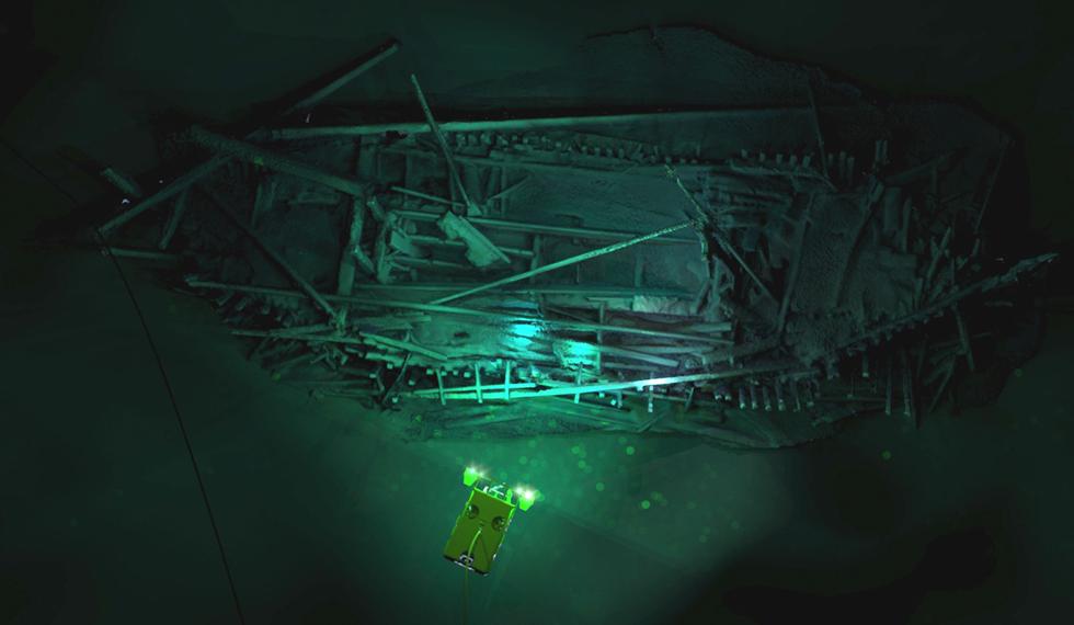
The images produced by the Black Sea MAP project, pictured here, are actually digital models created from photographs using the process photogrammetry, the technique of constructing a 3D model by computing the position of any point that is visible in any two adjacent images. Software computes the 3D positions of millions of points in space in this case from thousands of photographs (taken by the cameras on the ROV) and builds the model. What is seen in the final image is the model rendered and overlaid with the colors and textures from the photos to create an accurate representation.
Photogrammetric model of Ottoman wreck overlaid with Supporter ROV. Credit: EEF/Black Sea MAP
“Maritime archaeology in the deep sea has often been a contested domain, but this project, the largest of its type ever undertaken, demonstrates how effective partnerships between academia and industry can be, especially when funded by enlightened bodies such as EEF,” Professor Adams.
Karl Bell-(The Conversation)– Maritime folklore has long been shuffled to the margins of nautical history, presented as the quaint, colourful oddities of a former age. Yet this body of beliefs, practices...
By Will Dunham June 25 (Reuters) – Our species arose in Africa roughly 300,000 years ago and later trekked worldwide, eventually reaching some of Earth’s most remote places. In doing so, our ancestors surmounted geographic barriers including...
The Australian National Maritime Museum (ANMM) has released its final report confirming the discovery of one of maritime history’s most significant vessels – HMS Endeavour – in Newport Harbor, Rhode...
June 8, 2025
Total Views: 11251
Get The Industry’s Go-To News
Subscribe to gCaptain Daily and stay informed with the latest global maritime and offshore news
— just like 106,283 professionals
Secure Your Spot
on the gCaptain Crew
Stay informed with the latest maritime and offshore news, delivered daily straight to your inbox
— trusted by our 106,283 members
Your Gateway to the Maritime World!
Essential news coupled with the finest maritime content sourced from across the globe.

 Join The Club