Press Release – The UK Hydrographic Office (UKHO) has today announced its new ADMIRALTY GAM Service, developed in collaboration with Teledyne CARIS to improve efficiency during bathymetric data cleansing processes.
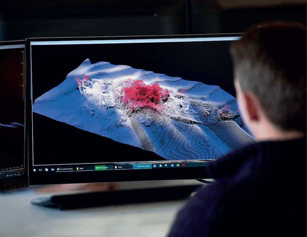
The new ADMIRALTY GAM Service classifies and removes sonar noise from bathymetric survey data using machine learning based on a Generalised Additive Model (GAM). The service uses cloud computing capabilities to examine and cleanse new multi-beam survey information, removing outlying data points within the data set.
This could include any point or cluster of points that are above or below where the actual slope being surveyed is, and random spikes in data that are inaccurate to the reality being surveyed.
The ADMIRALTY GAM Service provides the same levels of certainty and accuracy achieved through human data cleansing and manual noise identification, while significantly reducing the amount of effort and time spent on this process.
Hydrographers, geospatial analysts, marine geospatial specialists, survey and scientific research companies, and other Hydrographic Offices can benefit from this tool to substantially improve the volume and velocity at which data is refined, and invest the freed time and resource in analysing and adding value to that data.
The tool has been especially tailored to work with single track multi-beam sonar data such as that collected on a research cruise or voyage.
A recent trial conducted on a data set gathered during a two day, 900km voyage in the Southern Ocean, showed that the ADMIRALTY GAM Service algorithm took one hour and 30 minutes to identify the noise in a data set of marine depth data ranging from 100m to 3000m. Comparatively, manually identifying noise and outlying data would have required a trained expert to spend more than one day examining the data.
The ADMIRALTY GAM Service will be available and securely accessible through the Teledyne CARIS platform for users with an existing HIPS and SIPS licence.
Commenting on the announcement, Paul Marks, ADMIRALTY GAM Service Product Manager at the UKHO, said: “The new ADMIRALTY GAM Service that we are launching today is the result of years of work, development, and investment from the UKHO into the use of AI and machine learning to tackle the increasing levels of bathymetric data cleansing and verification tasks that our industry has to undertake.
“The new service significantly reduces the time it takes to process foundational bathymetric data from days to hours, which will increase the speed at which we deepen our understanding of the world’s oceans. The combination of our data science expertise and our knowledge in the field of bathymetry gives us the ability to bring solutions to the market that help experts and survey companies refine collected data into trusted, usable and analysable data quicker than ever before. We will continue to contribute to the wider ecosystem of bathymetry tools, methods and products in collaboration with Teledyne CARIS and our other industry partners.”
Karen Cove, Senior Manager of Products at Teledyne Geospatial, commented: “It’s an exciting time in our industry and Teledyne CARIS is pleased to be working with the UK Hydrographic Office to bring forward tools that can really make a difference in enabling hydrographic surveying efforts to scale in a cost effective and efficient manner. The new ADMIRALTY GAM tool will now be available in the CARIS HIPS & SIPS workflow and is a perfect complement to CARIS’ AI Sonar Noise Classifier released last year.”
To learn more about ADMIRALTY GAM Service, please visit: https://discover.admiralty.co.uk/access-data/seabed-mapping
About the UK Hydrographic Office (UKHO)
The UK Hydrographic Office is a leading centre for hydrography, providing marine geospatial data to inform maritime decisions. We work with a wide range of data suppliers and partners to support maritime navigation, safety, security and marine development around the UK and worldwide.
We make location-based information available through ADMIRALTY Maritime Data Solutions, our world-leading range of charts, publications and custom data sets. Our use of marine data and technology, combined with our expertise, ensures we continue to innovate and provide a wider range of solutions.
We source, process and provide access to location-based information, ranging from seabed to surface. This enables our partner organisations to make critical maritime decisions – informing the sustainable use and management of the marine environment and supporting the development of the blue economy.
Editorial Standards · Corrections · About gCaptain

 Join The Club