UKHO conducts seabed mapping surveys in Belize to support management of the marine environment and economic development
Press Release – The UK Hydrographic Office (UKHO) has started surveying the seabed of the southern waters of Belize as part of the UK Government’s Commonwealth Marine Economies (CME) Programme.
Almost all activity in our oceans, from shipping to monitoring delicate marine environments, depends on accurate seabed mapping data that illustrates the shape and movement of natural underwater features. For coastal nations like Belize, the collection of this data is vital to supporting sustainable economic growth and protecting communities from the effects of climate change.
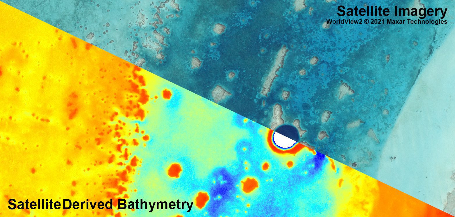
Following a stakeholder meeting with the Belize Port Authority and wider Belizean government in late 2019, it was agreed that the country’s southern waters would be surveyed using Satellite Derived Bathymetry (SDB). SDB uses satellites to capture high resolution imagery which can then be processed to calculate seabed depths down to 40 metres, depending on the clarity of the water. This method captures large areas quickly and has no negative impact on ecosystems and marine life. Data collection and processing is expected to take several weeks and will focus on areas south of Belize City.
Information from the survey will be used to update nautical charts of the region where necessary, reducing navigational risk and improving safety of life at sea. The SDB-generated information can also be used to plan and prioritise more detailed surveys of Belizean waters to support government requirements.
The data from the survey will be supplied to the Belizean government and can underpin a range of environmental and scientific applications, including improved management of coastal protection initiatives and the country’s rich marine environment. This includes the sustainable management of fisheries and other marine resources.
Ian Davies, International Hydrographic Portfolio Manager at UKHO, said:
“The new data being collected using funding from the Commonwealth Marine Economies Programme will help Belize to develop and manage its coastal waters, unlocking benefits for the nation for many years to come. The data gathered from this SDB survey will not only be utilised to check for dangers to navigation, but will also support other disciplines such as fisheries and coastal zone management, environmental planning, and maritime security. Equally importantly, it will also assist in the continued development of policies that protect the country’s marine environment and the sustainable use of Belize’s natural resources”.
About the Commonwealth Marine Economies Programme
Funded by the UK Government’s Conflict, Stability and Security Fund (CSSF) and led by the Foreign, Commonwealth & Development Office, the CME Programme is supporting 17 Commonwealth Small Island Developing States (SIDS) in the Caribbean and Pacific in identifying the potential of, and developing, their marine economies in a sustainable, resilient, and integrated way. The Programme promotes growth, innovation, jobs, and investment whilst safeguarding healthy seas and ecosystems. In partnership with the SIDS governments, the Programme will develop and implement national Maritime Economy Plans to ensure the Programme leaves a lasting legacy.
The Programme is delivering world leading expertise in marine science through its main delivery partners: the UK Hydrographic Office (UKHO), the Centre for Environment, Fisheries and Aquaculture Science (Cefas) and the National Oceanography Centre (NOC); and a team from Atkins with a mix of technical, institutional and regional experience are working in partnership with SIDS governments to support the development of bespoke Maritime Economy Plans, tailored to the national needs and priorities of each country.
The UKHO is a leading centre for hydrography, providing marine geospatial data to inform maritime decisions. We work with a wide range of data suppliers and partners to support maritime navigation, safety, security, and marine development around the UK and worldwide.
We make location-based information available through ADMIRALTY Maritime Data Solutions, our world-leading range of charts, publications, and custom data sets. Our use of marine data and technology, combined with our expertise, ensures we continue to innovate and provide a wider range of solutions.
We source, process, and provide access to location-based information, ranging from seabed to surface. This enables our partner organisations to make critical maritime decisions – informing the sustainable use and management of the marine environment and supporting the development of the blue economy.
The International Hydrographic Organization (IHO)’s new S-100 universal hydrographic data model promises to bring a range of benefits to the shipping industry, including improvements in navigation, operations and decarbonisation. Born...
By UK Hydrographic Office It is no exaggeration to say that shipping underpins the global supply chain. 90% of everything travels via ship. But it is also a sector that...
Seafarers have always relied on navigational equipment to steer their vessels safely across the oceans. However, the tools that modern mariners use compared to previous generations are, as expected, far...
August 8, 2023
Total Views: 6215
Get The Industry’s Go-To News
Subscribe to gCaptain Daily and stay informed with the latest global maritime and offshore news
— just like 104,822 professionals
Secure Your Spot
on the gCaptain Crew
Stay informed with the latest maritime and offshore news, delivered daily straight to your inbox
— trusted by our 104,822 members
Your Gateway to the Maritime World!
Essential news coupled with the finest maritime content sourced from across the globe.

 Join The Club