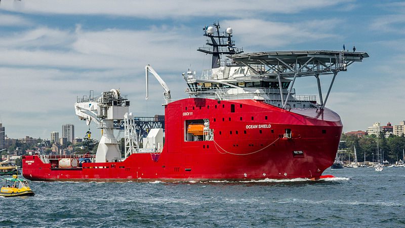
ADV Ocean Shield. Photo courtesy Hpeterswald/Creative Commons
By Jason Scott
April 5 (Bloomberg) — Crews hunting for the missing Malaysian jet are extending the search to beneath the surface of the Indian Ocean, listening for pings from beacons on the plane’s black boxes before the onboard batteries fail.
An Australian ship towing U.S. Navy sensors and a British survey vessel are conducting the underwater checks, bolstered by nine other craft and as many as 15 planes today, Australia’s Joint Agency Coordination Centre said in a statement. Fair weather was forecast in the area, with possible showers.
Finding the jet’s cockpit and flight-data recorders is crucial to unraveling a mystery that began March 8 when contact was lost with the Malaysian Airline System Bhd. plane. The challenge is narrowing the surveillance zone to get close enough to hear the black boxes’ pingers as their batteries near the end of a lifespan of about 30 days.
“The Australian Transport Safety Bureau continues to refine the area where the aircraft entered the water based on continuing ground-breaking and multi-disciplinary technical analysis of satellite communication and aircraft performance,” Australia’s JACC said in the statement.
The Royal Australian Navy’s HMAS Ocean Shield is scouring the sea floor with the U.S. Navy’s “towed pinger locator” and the U.K.’s HMS Echo boasts “similar capability,” retired Air Chief Marshal Angus Houston, who heads the JACC, told reporters yesterday in Perth, Australia.
Deadline Nears
Houston alluded to the race against the clock to detect signals from the pingers on the black boxes before their power gives out, saying, “We’re now getting pretty close to the time when it might expire.”
Today’s search will focus on three areas within a broader patrol zone of about 217,000 square kilometers (84,000 square miles), 1,700 kilometers northwest of Perth, the JACC said.
Flight 370, a Boeing Co. 777-200ER carrying 239 people, was deliberately steered off its flight path to Beijing from Kuala Lumpur and onto a course that ended in the southern Indian Ocean, Malaysian Prime Minister Najib Razak has said.
Investigators have relied on limited contact between Flight 370 and an Inmarsat Plc satellite to draw up possible paths for the jet after it vanished from civilian radar. Planes and ships from Australia, Malaysia, China, the U.S., South Korea, New Zealand and Japan are taking part in the hunt, the longest in modern passenger-airline history between a disappearance and initial findings of debris.
Available Data
“We’ve probably got to the end of the process of analysis and my expectation is, you know, we’re into a situation where the data that we’ve got is the data that we’ve got,” Houston said. “And we’ll proceed on the basis of that.”
The Echo, launched in 2002, can collect military hydrographic and oceanographic data and carries a detachment of marines, according to the British navy’s website. British nuclear submarine HMS Tireless also joined the hunt this week.
The multinational air-and-sea search is costing a “lot of money,” Houston said yesterday, without giving a figure.
The U.S. military has spent more than $3.3 million on its role in the multinational hunt and may spend as much as $8 million before the search ends, Army Colonel Steve Warren, a Pentagon spokesman, told reporters April 2.
So-called black boxes are actually bright orange to help find them in wreckage. While designed to operate at depths of 3.8 miles (6.1 kilometers) and may work in even deeper water, the range of the beacons’ pings is a mile, according to manuals from Honeywell International Inc., the maker of the equipment. That may make the signals hard to pick up even if an underwater microphone is over the correct location.
Undersea Mountains
It can be difficult to hear the pingers if they are blocked by undersea mountains. Layers of water with different temperatures can also damp sounds.
In the search for wreckage of Air France Flight 447, which crashed into the Atlantic Ocean off Brazil in 2009, authorities were able to focus on a 6,700-square-mile area after finding objects adrift five days following the crash. They also had a last known position and four minutes of signals from a jet- messaging system dubbed Acars, which was shut off on Flight 370.
Even with those clues, the pings from Flight 447’s recorders weren’t picked up. It took two voyages over almost a two-year period to find the debris field with unmanned underwater vehicles.
–With assistance from Edward Johnson in Sydney and John Walcott in Washington.
Copyright 2014 Bloomberg.
Editorial Standards · Corrections · About gCaptain
This article contains reporting from Bloomberg, published under license.

 Join The Club