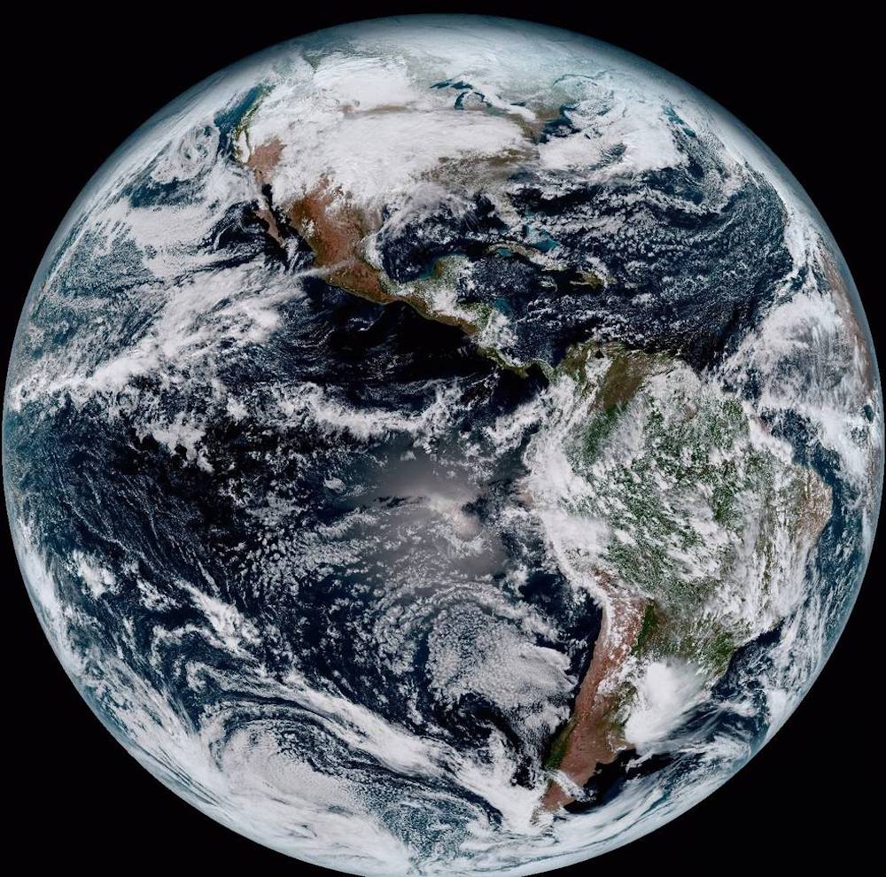
This composite color full-disk visible image is from 1:07 p.m. EDT on January 15, 2017 and was created using several of the 16 spectral channels available on the GOES-16 Advanced Baseline Imager (ABI) instrument. The image shows North and South America and the surrounding oceans. GOES-16 observes Earth from an equatorial view approximately 22,300 miles high, creating full disk images like these, extending from the coast of West Africa, to Guam, and everything in between. Photo: NOAA
NOAA’s next-generation weather satellite has sent its first images of Earth, well, back to Earth.
NOAA released the photos on Monday. The agency said the GOES-16 satellite, the first spacecraft in NOAA’s next-generation of geostationary satellites, captured the first high-resolution images using its Advanced Baseline Imager (ABI) instrument. Included in the images are a composite color full-disk visible image of the Western Hemisphere captured on January 15, 2017, an image of the continental United States showing the significant storm system crossing N. America on Jan. 15, 2017, and a 16-panel image showing the continental United States in the two visible, four near-infrared and 10 infrared channels on ABI. (More photos below)
NOAA says ABI covers the Earth five-times faster than the current generation GOES imagers and has four times greater resolution, allowing meteorologists to see smaller features of the Earth’s atmosphere and weather systems. The ABI can provide a full disk image of the Earth every 15 minutes, one of the continental U.S. every five minutes, and has the ability to target regional areas where severe weather, hurricanes, wildfires, volcanic eruptions or other high-impact environmental phenomena are occurring as often as every 30 seconds.
“Seeing these first images from GOES-16 is a foundational moment for the team of scientists and engineers who worked to bring the satellite to launch and are now poised to explore new weather forecasting possibilities with this data and imagery,” said Stephen Volz, Ph.D., NOAA’s assistant administrator for Satellite and Information Services. “The incredibly sharp images are everything we hoped for based on our tests before launch. We look forward to exploiting these new images, along with our partners in the meteorology community, to make the most of this fantastic new satellite.”
NASA successfully launched GOES-R on November 19, 2016 from Cape Canaveral in Florida. Once in orbit the satellite, orbiting 22,300 miles above the surface of the Earth, was renamed GOES-16.
The next spacecraft in the series, the GOES-S, will launch in Spring 2018.
“The image is much more than a pretty picture, it is the future of weather observations and forecasting,” said Louis W. Uccellini, Ph.D., director, NOAA’s National Weather Service. “High resolution imagery from GOES-16 will provide sharper and more detailed views of hazardous weather systems and reveal features that previous instruments might have missed, and the rapid-refresh of these images will allow us to monitor and predict the evolution of these systems more accurately. As a result, forecasters can issue more accurate, timely, and reliable watches and warnings, and provide better information to emergency managers and other decision makers.”
More of the photos are below:
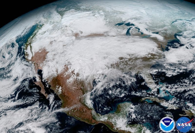
The image above shows the significant storm system that crossed North America that caused freezing and ice that resulted in dangerous conditions across the United States on January 15, 2017. GOES-16 will offer 3x more spectral channels with 4x greater resolution, 5x faster than ever before.
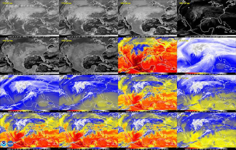
Above is a 16-panel image showing the continental United States in the two visible, four near-infrared and 10 infrared channels on ABI. These channels help forecasters distinguish between differences in the atmosphere like clouds, water vapor, smoke, ice and volcanic ash.
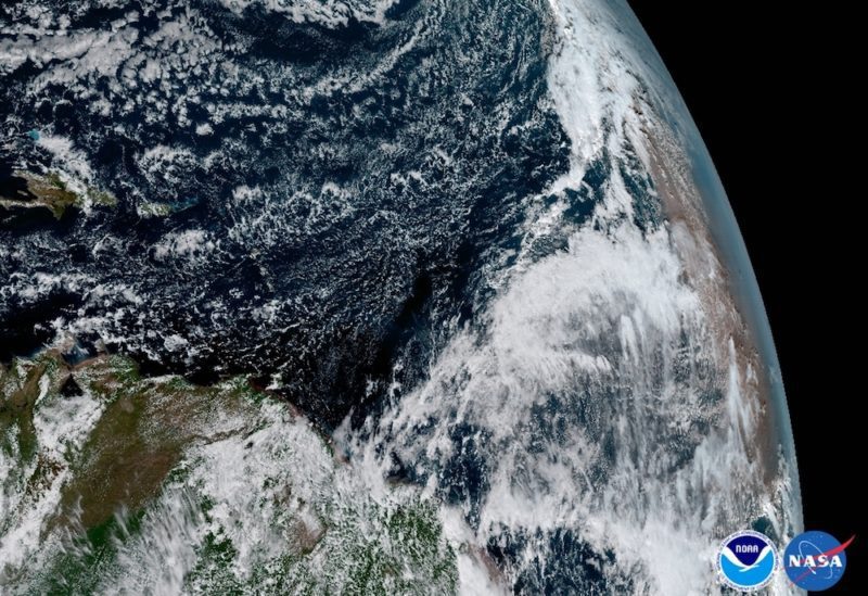
The Saharan Dust Layer can be seen in the far right edge of this image of Earth. This dry air from the coast of Africa can have impacts on tropical cyclone intensity and formation. GOES-16’s ability to observe this phenomenon with its 16 spectral channels will enable forecasters to study related hurricane intensification as storms approach North America, NOAA says.
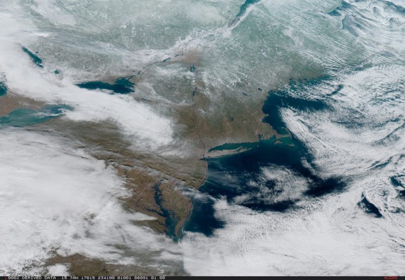
On January 15, severe weather moved across the central United States before passing through the Northeast on the 16th and 17th where it resulted in wet and wintry weather for travelers across the region.
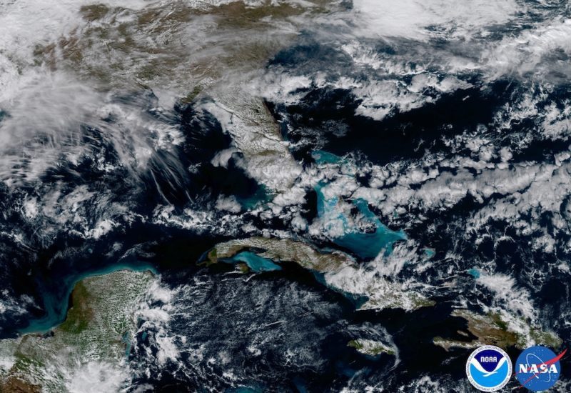
In May 2017, NOAA will announce the planned location for GOES-16. By November 2017, GOES-16 will be operational as either the GOES-East or GOES-West satellite. At its current check out location the satellite captured this image of the shallow waters of the Caribbean and Florida.
Editorial Standards · Corrections · About gCaptain

 Join The Club