In just two short years, Apple’s iPad has grown to dominate the world of tablet computing with over 48 million units sold. Tomorrow Apple is set to announce the third version of the unit, the iPad HD, so gCaptain wanted to take a minute to look at the best software options for the device. While none of them have IMO approval, you can be sure that these programs, and countless others, are being used on the bridges of countless commercial vessels.
The Best Mobile Charting App
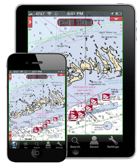
After months of testing various apps for both the iPad and android systems gCaptain’s favorite app for the iPhone is Navionics, and its $35 iPad version brings vector charting goodness to the larger screen of the iPad plus extra features (like gCaptain news feeds!) found more commonly on dedicated chartplotters.
The first advantage of this app is its use of Navionics vector charts. Other solid charting programs do exist. iNavX for example works well but doesn’t come with charts, rather users have the option to download free NOAA raster charts. But Navionics brings us vector charts which allow chart features to be accurately charted regardless of zoom levels (chart scale). And while most vector charts are based on the same NOAA data Navionics seems to do a better than most in getting that data to display correctly on the iPad screen.
In addition to charts, the Navionics app allows you to overlay weather information and it performs tide calculations on the fly. You can also overlay satellite photo images, a nice feature when you are creating a sail plan for an unfamiliar port. Navionics also gives you extra features beyond simple navigation including community layering of user-generated content which aggregates user reports and displays them on the chart. This additional layer can include everything from pilot times and phone numbers, to information on which taxi companies are best in a Port. Navionics reports that it has attracted more than 6,000 registered users who have contributed more than 100,000 new objects.
The newest feature of the Navionics app is “NewStand,” featuring articles about specific ports. Many of these articles are “geo-referenced” meaning that if, for example, gCaptain has written an article about the port you are visiting, that article will be show up in your newstand. So far Navionics has reported over 100 different publishers have signed on to the NewStand feature and, while most of them are focused on boaters, Navionics has recently made a push into including commercial content.
The app handles like a lean ECDIS display, however because it’s internet-capable, it can update data in real time and superimpose the information on the chart. On the dislpay itself, your current GPS location is shown in addition to “crosshairs” which the chart moves around. There are also buttons on the corner of the display with options for search, zoom in and out, GPS location, and settings. The current information, taken from the GPS, is displayed on the bottom along with buttons for basic data on your track and route. Our favorite feature is a very simple interface for calculating distance and bearing to objects and along your given route..
We also like the additional data hidden behind chart features. To activate the information you simply tap on the screen and drag the map until the feature you are interested lays beneath the “crosshairs”, one more tap of the screen and information on the chart feature pops-up.
For those who work on boats with Raymarine chartplotters, you have the ability to sync waypoints and data across your ship systems, however for the rest of us, Navionics does provide the ability to share waypoint information between other Navionics products like their desktop chartplotting software. A nice feature if you want to lay out courses on your computer rather than using the ipad touch screen.
Low Cost – High Quality Charting
EarthNC On The iPad and iPhone
If the cost of the Navionics app is out of your priceline, then try EarthNC’s excellent vector charting app. This app provides great vector charting and many extra features like multi-point routing support for its iPhone Marine Charts application.
What is multi-point routing?
This feature allows navigators to quickly plot a multi-segment course on their iPhone with heading and distance data per segment as well as the ability to dynamically “rubber band” routes. Another key feature of EArthNC is the ability to download the latest charts on the route directly from EarthNC’s cloud-based NOAA chart and weather server – thus assuring the very latest charts are available on the app.
EarthNC’s co-founder, Virgil Zetterlind said: “Our boater community has been asking for multi-point routing for quite some time and I’m happy to say that I think we’ve delivered what they’re looking for. It’s simple, easy and leverages our real-time, cloud-based chart and weather service. We’re going to be paying careful attention to the reviews and feedback to see how we should improve upon it. ”
Don’t like vector charts?
No problem, EarthNC also allows you to buy raster-chart versions for certain regions (more coming soon) and the app will update these charts weekly as corrections are pushed out to the device via EarthNC’s servers. The software also contains free “base maps” which include Google satellite, USGS cartography and CloudMade Road maps.
The one drawback… no ability to plan a route ahead of time and pre-load your ECDIS or ECS, like you can with the Navionics app.
The Bottom Line
The bottom line is that countless apps exist for the iPad and many more (including Navionics and EarthNC) are also available for Android but, after extensive testing by gCaptain editors, these two remain our favorites for commercial navigation.
by Kevin Hamilton (University of Hawaii) In 2021, an expedition off the icy northern Greenland coast spotted what appeared to be a previously uncharted island. It was small and gravelly,...
What is the definition of misery? Answer: Seasickness One of the first questions I get asked when a landlubber finds out I work at sea is, “Do you get seasick?” In...
Containerization is the reason we have a thriving global marketplace, but where did it all begin? The idea of it was actually conjured up on a busy dock in Hoboken,...
May 17, 2020
Total Views: 706
Get The Industry’s Go-To News
Subscribe to gCaptain Daily and stay informed with the latest global maritime and offshore news
— just like 105,332 professionals
Secure Your Spot
on the gCaptain Crew
Stay informed with the latest maritime and offshore news, delivered daily straight to your inbox
— trusted by our 105,332 members
Your Gateway to the Maritime World!
Essential news coupled with the finest maritime content sourced from across the globe.

 Join The Club