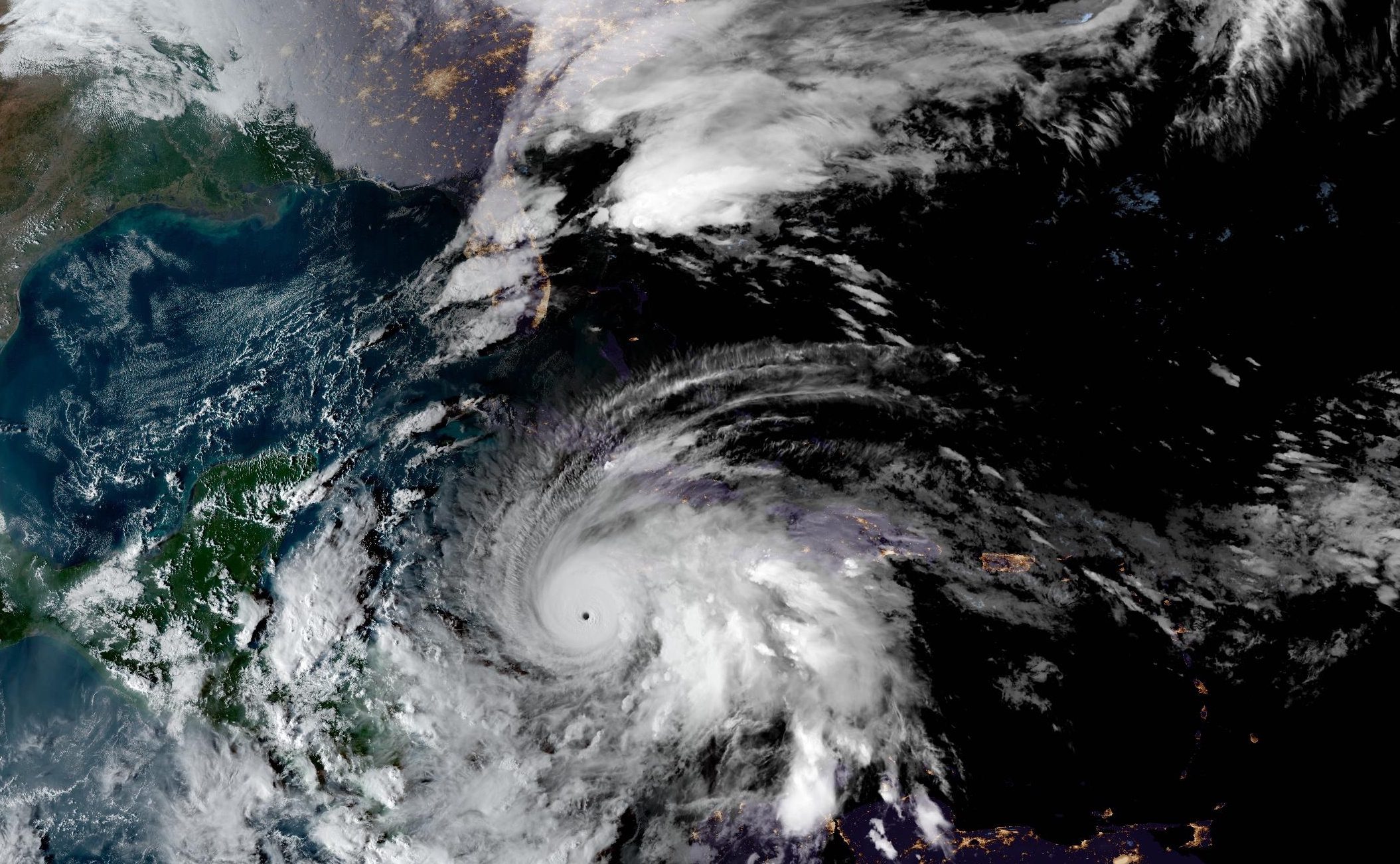
Hurricane Melissa intensified into an extremely dangerous Category 5 storm on Tuesday morning as it closed in on Jamaica, with maximum sustained winds reaching 185 mph and a central pressure of 892 millibars, making it one of the most powerful Atlantic hurricanes on record.
According to the National Hurricane Center’s 11 AM EDT advisory, the storm was located approximately 40 miles southeast of Negril, Jamaica, and was “about to make landfall” with “catastrophic winds, flash flooding, and storm surge occurring on the island.”
The agency warned that “catastrophic hurricane-force winds are spreading over Jamaica within the eyewall of Melissa” and that “total structural failure is likely near the path of Melissa, especially in higher elevation areas where wind speeds atop and on the windward sides of hills and mountains could be up to 30 percent stronger.” The advisory urged residents not to “venture out in the eye as winds will rapidly increase within the backside of the eyewall.”
Hurricane-force winds extend outward up to 30 miles from the center, while tropical-storm-force winds reach out to 195 miles.
The rainfall forecast is equally dire. Jamaica can expect 15 to 30 inches of rain, with storm total local maxima of 40 inches possible, leading to “catastrophic flash flooding and numerous landslides.”Southern Hispaniola will see an additional 6 to 8 inches with localized amounts up to 12 inches.
Storm surge presents another life-threatening hazard. Peak surge heights could reach 9 to 13 feet above ground level along Jamaica’s south coast “near and to the east of where the center of Melissa makes landfall,” accompanied by “large and destructive waves.”Even the northwest coast near Montego Bay faces the possibility of 2 to 4 feet of storm surge.
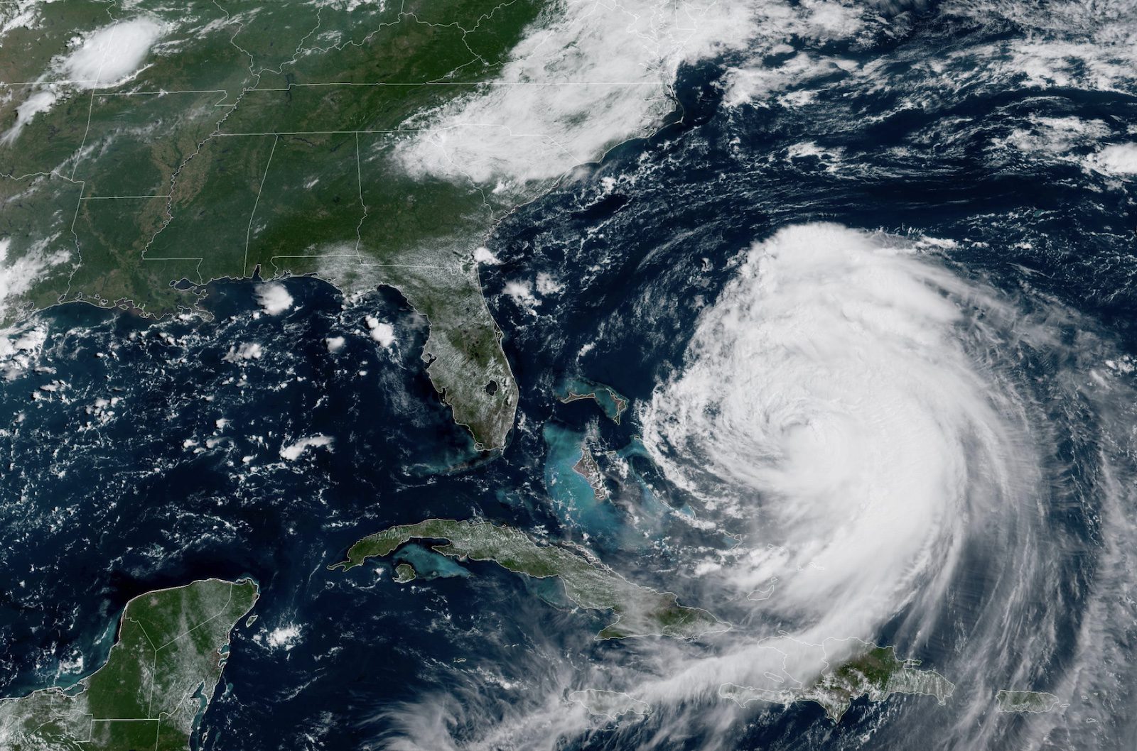
After devastating Jamaica, Melissa is forecast to move across southeastern Cuba early Wednesday morning, where it will still maintain major hurricane status. Eastern Cuba can expect storm total rainfall of 10 to 20 inches, with local amounts to 25 inches, “resulting in life-threatening and potentially catastrophic flash flooding with numerous landslides.”Storm surge along Cuba’s southeast coast could reach 8 to 12 feet above normal tide levels.
The hurricane is then expected to track across the southeastern or central Bahamas later Wednesday, where it will still be a strong hurricane, bringing 5 to 10 inches of rainfall and storm surge of 5 to 8 feet.The Turks and Caicos Islands face tropical storm conditions with 2 to 4 inches of rain and 2 to 4 feet of storm surge.
By Thursday or Thursday night, Melissa is forecast to pass near Bermuda as it begins transitioning to an extratropical cyclone over the North Atlantic. The storm is expected to encounter increasing southwesterly vertical shear after leaving Cuba, causing steady weakening, though “the cyclone should still be at hurricane strength when it passes near Bermuda.”
Hurricane warnings remain in effect for Jamaica, five Cuban provinces (Granma, Santiago de Cuba, Guantanamo, Holguin, and Las Tunas), and the southeastern and central Bahamas.Tropical storm warnings cover Haiti, Cuba’s Camaguey province, and the Turks and Caicos Islands.
The next complete advisory from the National Hurricane Center is scheduled for 5 PM EDT.
Editorial Standards · Corrections · About gCaptain

 Join The Club