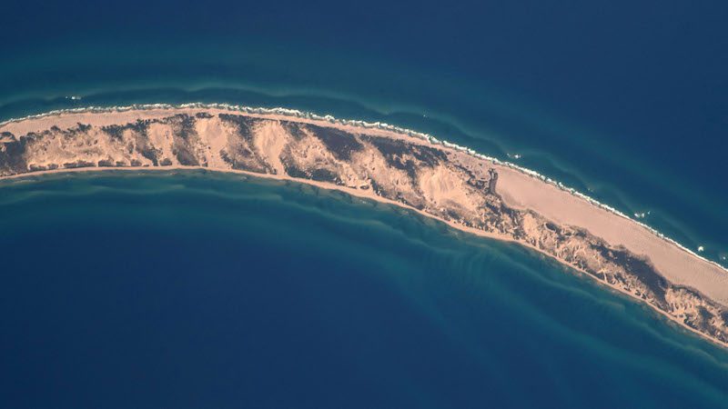
Sable Island, Canada. Credit: NASA
By Michael Carr – “Keep reading out continuous depths under the keep,” said the schooner’s captain.
“Keep giving us soundings, every 10 seconds or if you see a significant change.” Visibility on this day ranged from 50 to 100 feet due to the pea soup fog. Fog, which had been a constant for the past week.
Now, they were attempting to make landfall at Sable Island, which is not really an Island but a large sandbar in the Atlantic Ocean. Sable Island sits 190 miles SE of Halifax Nova Scotia, at the edge of the continental shelf.
It exists where the cold south running Labrador Current meets warm northerly flowing Gulf Stream waters. A slowing of currents causes sediment to fall out of the water and form this narrow, east to west oriented sand bar. Extreme air and water temperature difference produce nearly constant advection fog. There is little need to consult Bowditch Table 36 (Dew Point) to determine when fog might form, as it feels as if Dew Point temperature is constant.
Water drips off the schooner’s rigging and sails. The schooner’s crew is thankful for the large diesel stove in the galley to dry their foul weather gear and keep the boat’s interior warm. Hot coffee and hot chocolate fuel their watches. They had departed Portland, ME the previous week, and sailed in fog ever since. Their passage was noted by the their foghorn; three blasts in succession every two minutes-one prolonged and two short. Watches were busy with regular security calls, VHF communications with unseen vessels, and a vigilant DR plot with Loran C lines. Their efforts had now brought them, theoretically, to within a few miles of Sable Island. But all they could see was fog, depths from a fathometer, and sea return on the radar.
Sable Island is shaped like a banana, lying east to west at 44 N latitude. It’s low sloping dunes provide little to no radar return, and there are no distinguishing Island features. On clear days, you only see Sable Island when you are few miles off, and if you are too close to the east or west ends it is likely you have already run aground by the time you see the Island. This is why there are over 350 known shipwrecks on Sable Island. Sand bars, currents, fog, un-forecast gales and squalls, all conspire to push ships up on Sable Island.
Avoiding Sable Island, giving it a wide berth, is what most prudent mariners do, but on this voyage they were going to make a landing. They had sailed past the west end of Sable Island the previous night, on a broad reach made possible by south and southwest winds. The same winds that were making the thick fog by pushing warm moist air over the cold Labrador Current.
Now they were, at least according to their DR plot, due north of Sable Island, at a position midway between the Island’s east and west ends.
“Our plan is to sail due south now, aiming at the Island’s midpoint. We will watch soundings and use the radar. We will also have our bow lookout listen for the sound of surf,” the captain explained to his crew.
“Let’s douse the sails now, and start motoring.”
Slowly, at 3-5 knots they headed due south, plotting fixes every five minutes. Soundings, Loran lines, DR plot. But nothing on the radar.
“I know the Island is here,” the captain said to himself, “But I sure wish it would show up on radar.”
Sloping sand dunes do not readily return radar pulses, and Sable Island is all sand dunes. They were now only 3 miles north of where Sable Island should be, and still no indication on the radar. Soundings showed 50 to 60 feet, but around Sable Island sand bars form and disappear without notice. Charts for the area loudly proclaim “Shifting and uncharted sandbars, Caution advised.”
And then, finally, the faintest return on the radar. Returns from port and starboard, indicating the east and west ends of the Island. The schooner’s navigator ranged in and out on the radar, plotting ranges, & re-plotteting ranges. They were all aware not to make information fit their needs.
“Let’s get a really good fix from those ranges, double check with Loran Lines and depth. If they don’t match, tell me. It could be garbage,” the captain cautioned.
“Let’s keep heading south.”
And then the radar return became more pronounced, return from the 3-mile range showed contours of the island’s north side, it was weak, but consistent. Then the fog started to thin. This made sense, since warm land frequently burns off the fog over it. Then, the fog lifted and there in front of them was Sable Island. Magically appearing out of nowhere. They could see wild horses on the beach, and dunes to the left and right for miles.
“Prepare the port anchor,” yelled the captain. “Continue reading soundings, we will anchor in 20 feet, and start sounding with the lead line.”
All the crews was on deck, amazed at having found this place in the middle of the fog-shrouded Atlantic Ocean. Soon they were in 20 feet of water, about a ¼ of mile off the beach. “Stand by to drop the port anchor,” he shouted to the bow. He backed down, brought the schooner to a stop. “Drop the port anchor and pay out 140 feet of chain to the water’s edge,” he added. A scope of 7:1 with their 200 lb. Luke anchor should hold. No way was he going to allow them to drag up on the beach. “Backing down now!” he shouted to the bow, and after a minute of backing down came the response, “Anchor holding, chain tending forward.”
They were fortunate, the winds were light today, but there was a gale warning for tonight. If they were going to go ashore, they needed to go now.
“Set the anchor watch, and launch the inflatable,” he instructed his crew. “We will send crew ashore in groups and rotate through. If there is any type of emergency, we will start blowing the horn, non-stop.”
Now was not the time to let excitement overtake their vigilance and seamanship. The inflatable was launched and easily landed on the sand beach. Surf was less than a foot. They hiked over the dunes to the Canadian Weather Station, and plodded through thick sand to the island’s south shore, where surf was huge and pounding the beach. Miles of empty beach with massive spraying surf and fog. Who would not be awed by the power and majesty of this environment?
As nightfall approached, the wind began increasing. Oh so imperceptibly. The skipper could feel it coming. One minute all was calm, and then that whisper of wind from the NE. One little gust, then another. “Here it comes,” he said to his crew. “It’s going to be a sleigh ride to Lunenburg.”
They raised anchor and motored north, following the same track line they used to approach Sable Island. Once they were far to the North they raised sail, secured the engine, and fell off on a port tack. The gale was coming; winds were now at 20 knots with higher gusts. They knew it would reach 35 knots overnight.
“Let’s secure the main. Put a third reef in the for ‘sail, and keep up the staysail,” the skipper instructed the Bosn. That will keep our center of effort low and forward, and will make it easier to steer through the night.”
But midnight they were in full-blown gale, but the ride was good, they were broad reaching downwind, the wind and seas going with them. They were making 10+ knots, plowing into and through the building seas. But they felt safe and secure. The steel schooner was robust and well cared for, the crew were the finest sailors, and they worked as a team.
“Keep her to it and drive her hard!” the skipper said to the night watch, taking a line from Rudyard Kipling’s Captain’s Courageous. He stood in the dark cockpit bantering with the watch. Only the light from the compass binnacle, and glow of the running lights intruded into the darkness, rain and spray.
“How’s she steering?” he asked the helmsman.
“Easy skipper, no strain, just tracking alone fine, wicked good.”
“Nice,” he replied. “I am going down to my bunk, if the wind goes over 40 knots, or shifts, requiring sail adjustment, wake me.” he instructed the watch. “Have a great watch, tomorrow we should be in Lunenburg.”
He went below, laid out his foul weather gear, and rolled into his bunk. He could tell by the schooner’s motion & relaxed talk from the watch, that all was good. In minutes he was asleep.
Chief Warrant Officer 4 Michael W. Carr is a retired U.S. Army Watercraft Master and U.S. Navy Diving & Salvage Officer.
Updated: February 28, 2019 (Originally published February 10, 2019)
Editorial Standards · Corrections · About gCaptain

 Join The Club