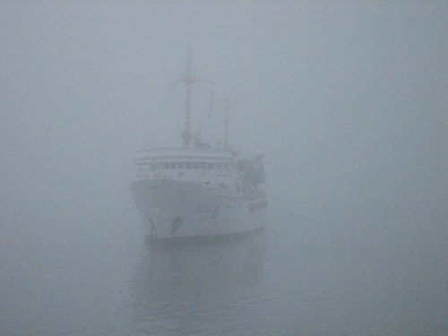
While perusing the NOAA website this morning, I came across an interesting article on something we are all to familiar with here on the Central and Northern California Coast: FOG. As much as it is literally a daily part of our lives here, it never ceases to amaze me just how quickly a marine layer can roll in off the Pacific, sit in the valley’s and then just as quickly burn off in the heat of the sun.
The article looks at the phonomenon of fog, exaclty what it is costing us and what NOAA is doing to mitigate the loss of life, property and resources from this everyday occurrence. —
Fog… it rolls, it creeps, it pools. It’s part of every good horror movie. But while you won’t find ghosts or monsters in real fog, it can pose some scary hazards for air, land, and water transportation.
A simple cloud in contact with the ground, fog makes it difficult for ships, trains, cars and planes to see each other. Notable accidents due to fog include the 1945 crash of a B-25 Mitchell into the Empire State Building; the 1956 collision of the ocean liners the SS Andrea Doria and MS Stockholm; the 1977 collisioin of Pam Am and KLM planes at the Tenerife Airport (the worst in aviation history); and the 2008 Interstate 4 70-vehicle pileup [not to mention the infamous 2007 Cosco Busan allision].
Beyond the loss of life and property, fog makes our nation’s commerce and transportation systems less efficient. Weather-related crashes cost an average of $42 billion annually in the United States from personal injury, loss of life, and property damage (Lombardo, 2000). The estimated cost of weather-related delay to trucking companies ranges from $2.2 to $3.5 billion annually (DOT, 2007). And each year, $6 billion is lost due to air traffic delays, of which $4.2 billion (70 percent) is attributed to weather (Air Transport Association, 2002).
However, research shows that improved environmental data via an enhanced NOAA GOES satellite imager and sounder would improve the way NOAA sees short-term ice and fog formation and issues dense fog advisories, which would benefit the transportation industry by millions of dollars. NOAA’s satellite enables us to provide:
- Improved short-term ice formation and fog condition forecasts (e.g., more than 2 hours notice) exceeds $29 million a year in benefits derived from rerouting efficiencies in the trucking industry (Adams et al., 2004)
- Improved marine forecasts of winds and waves, creating an economic benefit of $95 million a year for commercial shipping, from transit time savings and cargo loss reductions (NOAA, 2004)
- Weather sensing, data fusion, and forecasting services create an economic benefit of $590 million a year from improved travel safety and national delay reduction. Benefits for specific airports include: $16.7 million for Seattle-Tacoma International Airport, $25.7 million for Los Angeles International Airport, and $119 million for San Francisco International Airport (Evans et al., 1999)
- Integrated terminal weather system services provide economic benefits of $176 million a year from improved air traffic decision making, reducing gridlock and delays (Alan et al., 2001)
- Regional ocean observing systems, which reduce the risk of maritime accidents, improve search and rescue, etc., may be worth more than $30 million a year to the Gulf of Maine and $300 million a year to all U.S. coasts (Kite-Powell et al., 2005).
NOAA’s meteorological data is requested in a wide variety of situations where weather plays a major role in accidents, disasters, or mysteries.
Real-World Applications
An air transport company contacted NOAA’s National Climatic Data Center to check on the disappearance of one of their light aircraft. The aircraft was lost in foggy conditions over Lake St. Clair after taking off from Port Huron, Michigan. NCDC supplied surface observations to reflect the conditions at the estimated time of the disappearance. It appeared that the aircraft struck a channel marker that sticks up about 20 feet from the surface of the lake.
The U.S. Coast Guard contacted the NCDC to get meteorological data that was used to piece together how two boats collided on the intra coastal waterway of Louisiana. NOAA’s Satellite Services Group supplied the Coast Guard with GOES satellite imagery to help determine if fog was a major factor in the accident.
Lawyers commonly request and use NOAA fog, weather, and climate data in a wide variety of court cases to determine the severity of environmental conditions.
Listen to a NOAA public service announcement about navigating in dense fog.
For more information about fog, visit NOAA’s Fog Monitor.
Updated: February 5, 2026 (Originally published September 15, 2009)
Editorial Standards · Corrections · About gCaptain

 Join The Club