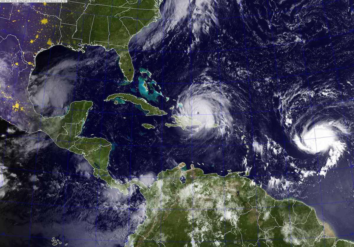
A GOES satellite image taken Sept. 7, 2017 at 8:45 a.m. EST shows Hurricane Irma, center, and Hurricane Jose, right, in the Atlantic Ocean, and Hurricane Katia in the Gulf of Mexico. U.S. Navy Photo
By Brian K. Sullivan (Bloomberg) — Irma has ripped a path of misery through the Caribbean and is aiming at Florida, but the first seed for its monster size and force was planted on the other side of the world more than six months ago.
It happened innocently enough, when a widely anticipated El Nino failed to materialize over the Pacific Ocean. In time, that cleared a path for a hurricane to form in the Atlantic that grew to the size of the state of New York with winds topping 185 miles per hour.
“The odds of getting an Irma in an El Nino year are really low,” said Phil Klotzbach, lead author of Colorado State University’s seasonal hurricane forecast. Peruvian fishermen back in the 1600s gave the recurring meteorological event its name, Little Boy or Christ Child in Spanish, when they noticed the tropical Pacific warming around Christmas in some years.
El Nino occurs when the Pacific heats up and flusters the atmosphere, setting off a chain reaction that causes wind shear across the Atlantic. Shear is wind blowing in different directions or speeds at various altitudes, and it can be Kryptonite for hurricanes. As powerful as they are, tropical cyclones have delicate structures. Shear can tear them apart. A budding storm can’t get started and an established storm can’t get strong.
Beasts like Irma churn out from one of the tropical waves that slide off the coast of Africa. These troughs of low pressure, sometimes just a ragged collection of thunderstorms, begin to roll off the continent in late spring. That’s a reason the Atlantic hurricane season runs from June 1 to November 30.
The waves are the seedlings, said Rick Knabb, hurricane expert at the Weather Channel in Atlanta and until last year director of the National Hurricane Center in Miami. “Hurricanes don’t just pop out of nowhere.”
Atmospheric Boost
They need warm water for fuel, which this summer has provided. The water in the tropical Atlantic, from the Leeward Islands to Cape Verde, has been about 2 degrees Fahrenheit (1 Celsius) higher than normal in the area where Irma is prowling, Klotzbach said.
Irma also got a boost from a deep, moist atmosphere. Earlier in the summer in the Northern Hemisphere, dry air usually blows off Africa’s Sahara Desert, sometimes carrying dust that can be seen from space and can give the Miami sky a hazy cast. That wraps into storms, sapping them of strength.
“Around Aug. 20, the dust tends to die down,” Klotzbach said. And then hurricane season begins, building to its Sept. 10 statistical peak, according to the National Hurricane Center.
All the ingredients combined to create one of the strongest storms ever to rise out of the Atlantic Ocean and the most powerful to form outside of the Caribbean and the Gulf of Mexico.
For those keeping score, however, Irma still can’t be called the most intense ever recorded in the Atlantic. That honor is held by 1980’s Allen, which packed winds of 190 miles per hour.
But the season isn’t over. Normally, the 11th named storm doesn’t show up until Nov. 23, according to the hurricane center. Irma is No. 9, and 10 and 11, Jose and Katia, are already here.
© 2017 Bloomberg L.P
Editorial Standards · Corrections · About gCaptain
This article contains reporting from Bloomberg, published under license.

 Join The Club


