Iranian Ship Linked to Houthi Attacks Heads Home Amid Tensions
(Bloomberg) — An Iranian ship that’s been linked to Houthi attacks in the Red Sea is returning home, removing a prominent asset in the area as the Islamic Republic braces...


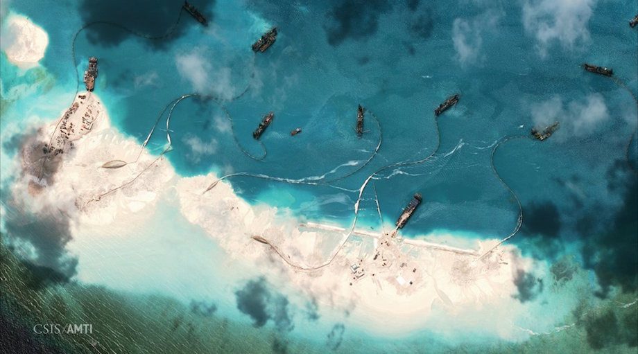
Dredgers deposit sand on the northern rim of the Mischief Reef, located 216 km (135 miles) west of the Philippine island of Palawan, on February 1, 2015. REUTERS/CSIS’s Asia Maritime Transparency Initiative/Digital Globe/Handout
![]()
![]()
By David Brunnstrom
WASHINGTON, Sept 15 (Reuters) – China was carrying out land reclamation in contested waters of the South China Sea this month, more than four weeks after saying it had stopped such activity, a U.S. expert said on Tuesday, citing recent satellite images.
The evidence of continued dredging in the Spratly archipelago could complicate a visit to the United States by Chinese President Xi Jinping next week, when U.S. concerns about China’s assertive pursuit of territorial claims in Asia are expected to be high on the agenda.
Bonnie Glaser, of Washington’s Center for Strategic and International Studies think-tank, said images taken in early September showed dredging activity at both Subi Reef and Mischief Reef in the Spratlys.
The dredgers at Subi could be seen pumping sediment on to areas bordered by recently built sea walls and widening the channel for ships to enter waters enclosed by the reef.
At Mischief Reef, a dredger was expanding a channel to enable easier access for ships, possibly for use as a naval base, Glaser said.
On Aug. 5, Chinese Foreign Minister Wang Yi said China had halted land reclamation in the sea.
Speaking in Beijing on Wednesday, Wang did not address the issue of whether reclamation had ended or was going on, but said “necessary” construction work was to improve conditions on the islands.
“The Nansha islands are China’s territory. In this regard, China possesses ample historical and legal basis,” Wang said, using the Chinese name for the Spratly Islands.
Glaser said China’s activity appeared to be focused on construction for military use.
Images of Fiery Cross Reef showed a completed and freshly painted 3,000 meter runway, helipads, a radar dome, a surveillance tower and possible satellite communication facilities, she said.
Security experts say a 3,000 meter strip would be able to accommodate most Chinese military aircraft.
Glaser said China’s apparent preparations to build similar airstrips on Subi and Mischief Reefs raised questions about whether it would challenge freedom of navigation in the air and sea in future.
“The persistence of dredging, along with construction and militarization on China’s artificial islands, underscore Beijing’s unwillingness to exercise self-restraint and look for diplomatic paths to reduce tensions,” she said.
“On the eve of President Xi Jinping’s visit to the United States, Beijing appears to be sending a message to President Barack Obama that China is determined to advance its interests in the South China Sea even if doing so results in heightened tensions with the United States.”
On Monday, Greg Poling, director of CSIS’s Asia Maritime Transparency Initiative (AMTI), which obtained the images, said three airstrips in the Spratlys would allow China to threaten all air traffic over features it has reclaimed there. (Additional reporting by Michael Martina in BEIJING; Editing by Ken Wills, Robert Birsel)
(c) Copyright Thomson Reuters 2015.
Join the gCaptain Club for curated content, insider opinions, and vibrant community discussions.


Join the 105,960 members that receive our newsletter.
Have a news tip? Let us know.
Access exclusive insights, engage in vibrant discussions, and gain perspectives from our CEO.
Sign Up


Maritime and offshore news trusted by our 105,960 members delivered daily straight to your inbox.


Essential news coupled with the finest maritime content sourced from across the globe.
Sign Up