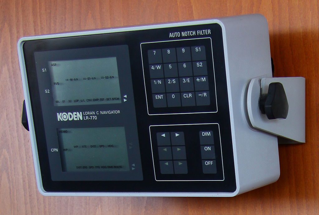
File photo shows a Loran-C receiver. Photo: CC BY-SA 3.0
Wayne was steering and I was navigating, but I knew we were not navigating in the way Bowditch defines the art and science of this endeavor.
We were making 8 knots to stem an outgoing tide, any slower and we would have a difficult time offsetting set and drift. We had no visibility, pea soup fog had set in at sunset and we had been enduring condensation and cold for hours now. The fog was so thick there was no point in looking out the Nordhaven trawler bridge windows. There was nothing to see, just condensation dripping down the thick glass.
We had no radar, no depth sounder. We did have a magnetic compass, but no deviation table. We did have a VHF radio and a Loran C. We had no autopilot, which is why Wayne was driving and I was “navigating”. We were running Loran C lines. Getting on a specific line and then steering a course to stay on that line, or as close to the line as possible.
I had a paper chart, dividers, a bunch of #2 pencils and a Loran C interpolator. A Loran C interpolator is a credit card-sized nomogram that allows you to measure distances between Loran C lines, enabling a navigator to plot a fairly accurate position.
Loran C lines are numbers and colored lines printed on charts, that represent time difference between land station towers, which broadcast time spaced signals. Before the magic of GPS, Loran was the only reliable electronic navigation system.
I looked at the Loran C numbers displayed on our receiver, wrote those numbers down, and then located relevant pre-printed baselines on the chart. I then interpolated between the printed lines to plot our position. Loran C is accurate to within 200-300 feet of your “actual” position. This accuracy is acceptable when you have some visibility or are away from immediate dangers, but once you make landfall, having some additional navigation information is helpful. We had none.
We were making landfall at Bass Harbor Maine, having departed Portland, Maine, that morning. Visibility was fairly good throughout the day, with some spotty fog, but as the afternoon wore on and the sun began disappearing in the west, the dew point temperature hit us. Fog formed around us, and every water molecule in the Gulf of Maine condensed, or so it seemed. We could see the Nordhaven’s bow 20 feet away, but no further.
I plotted a track line lying parallel to a printed Loran line, and which led us towards Blue Hill Bay and Bass Harbor. This track line was not the most direct, but it allowed us to more easily navigate, and plot our position. I started broadcasting security calls on VHF 13 and 16, but no replies came back.
“Wayne, there is no one out here but us,” I said. Wayne, an engineer, did not like the fog. It was dark, wet, cold, and there was no visibility, and it was just the two of us. Wayne was from Florida. There is no fog in Florida. “We are going to get in tonight, right?” Wayne queried me. I knew the answer Wayne wanted to hear, which I gave him; “Absolutely Wayne, just a few more hours of this nonsense and we will be in Bass Harbor, tied up and sleeping on our bunks.”
“Good” Wayne replied, “Because I really don’t like this.”
I did not like this either, but I was not going to share my thoughts with Wayne. Worst-case scenario, I thought, was the Loran C stopped receiving signals and we would have to heave to, stop, and drift for the night. Wait for the sun to come up and hope the dew point would go up a few degrees and the fog would dissipate.
But for now, I was plotting fixes and giving Wayne headings. The magnetic compass was not calibrated because this was a new Nordhaven; it had just come off a container ship in New York a few days earlier. We were ferrying her to Bass Harbor Maine for a new owner. She still had that “new boat” smell of epoxy and polyester resin, rubber, and wood.
Around midnight we were due south of Bass Harbor. We now had to wind our way northwest through a plethora of rock shoals and small islands. We could follow Loran C lines NW keeping Long Island and Swan Island to port and Green Island, Black Island and Placentia Island to starboard. But with no radar and no visibility, and no depth sounder all I could do was keep up speed, plot continuous fixes and give Wayne course corrections.
It went something like this; “Wayne, turn to the right, just a few degrees, and hold that.” I would then plot Loran lines as quickly as possible, keeping the best level of accuracy I could under the conditions. I would then compare that fix to our previous fixes, construct a quick DR, and give Wayne a course correction. “OK, Wayne looks like we need to come to the right a few more degrees.”
I was plotting fixes one right after another. Fix intervals were no more than 3-6 minutes apart, and the track line on the chart had what seemed to be hundreds of electronic fix triangle symbols plotted with a time next to each.
When our fixes showed us abeam of Staple Ledge Can buoy #1, which we could not see, I told Wayne to come right quickly. “Wayne, use full rudder and come right”. I watched the compass swing and then had him come back amidships before we swung past the next Loran C line. Wayne looked at me with wide eyes. Here we were in the middle of the night, making significant course changes in the fog, with no visibility, while steaming along at more than 8 knots.
“Do you think we should slow down some?” Wayne queried. “No” I replied, “If we slow down the set and drift from the current will put us all over the place. We need to reduce our exposure to being pushed by the current by keeping up speed. “OK” Wayne replied, “You’re the skipper.”
Once we turned at Staple Ledge Can buoy #1, I headed us directly towards Gong Buoy “WB”, which marks the channel through Weaver Ledge. My plan was to find that Gong Buoy, steam right up on it and then we could turn north, slow down and make our way into Bass Harbor. I knew Loran C was not sufficiently accurate to get us into Bass Harbor, but if we found the Weaver Ledge gong we had less than a mile to the Bass Harbor docks.
We steamed towards Gong “WB” and when a Loran C fix showed us almost on top of the buoy I said to Wayne, “Pull the throttle back to neutral, let’s listen for the Gong.” After hours of hearing the Lugger Diesel powering along at full RPMs it was eerily quiet. We both stepped out onto the bridge wings to listen for the gong, but there was no sound. There was no wind, no waves, and no motion to make the gong sound. All we could hear was exhaust from the stack.
I was tired, the adrenaline from hours of navigating was vaporizing, and I could feel exhaustion setting in. Really, I thought we had steamed through pea soup fog all night and navigated right up to this gong buoy, and now we cannot hear it! Then I briefly became uneasy. Maybe we were not at the gong buoy Maybe the Loran C is all jacked up or I have failed in my navigation and we are not where I think we are. Maybe we are about to go aground on a granite ledge! No, all is good I said to myself, we just need to make awake so the gong will sound.
As I was about to engage the Nordhaven’s engine and make a few donut loops in hope of motivating the gong buoy to sound Wayne and I heard an outboard engine. The sound of the outboard was getting closer. And then a faint light, and then Stephanie, a rigger from Bass Harbor Marine, comes out of the fog and alongside in an inflatable. “I heard your security calls on Channel 16 and came out to meet you.” She said.
Wayne and I grinned at each other. “Thank you, wicked good!!” we said together. We followed Stephanie into Bass Harbor, and up the harbor to the docks in Bernard. We were home.
Editorial Standards · Corrections · About gCaptain

 Join The Club