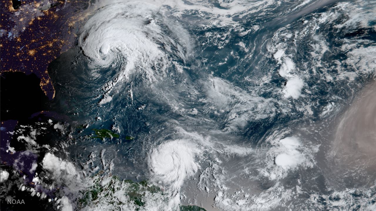
NOAA’s GOES-16 satellite captured this image of Hurricane Jose, Hurricane Maria and Tropical Depression Lee on September 18, 2017.
Update (10:30 a.m. ET, Sept 19): Hurricane Maria has been upgraded to a Category 5 hurricane with maximum sustained winds of 160 mph.
Latest Updates on Hurricane Maria: www.nhc.noaa.gov
 By Robert Edison Sandiford BRIDGETOWN, Barbados, Sept 18 (Reuters) – A rapidly strengthening Hurricane Maria barreled towards the eastern Caribbean islands with 125 mile-per-hour (200 kph) winds on Monday, threatening the region with its second major storm this month.
Officials from French-controlled Martinique to the U.S. Virgin Islands warned residents to prepare for the storm, now ranked by U.S. forecasters as a major hurricane, at Category 3 on the five-step Saffir-Simpson scale.
Maria was located about 45 miles (70 km) east of Martinique, headed west-northwest on a track that would put it over the U.S. territory of Puerto Rico by Wednesday, the U.S. National Hurricane Center said in a 2 p.m. ET (1800 GMT) advisory. The hurricane was expected to continue to strengthen during the coming two days, the center said.
Residents of some islands fled ahead of the storm.
Beth Tamplin Jones, 45, rode out Hurricane Irma earlier this month in the pantry of a friend’s house on St. John in the U.S. Virgin Islands.
“It was so intense,” said Jones, who evacuated from St. John to Puerto Rico last week and then got a flight to Atlanta, where she planned to remain until Maria passed.
“We’re in hurricane alley, so we’ve had other storms, but nothing like this,” Jones said, referring to Irma, which was one of the most powerful Atlantic hurricanes ever recorded and which killed more than 80 people on Caribbean islands and the U.S. mainland. “I don’t think anybody’s ever been hit by a storm like that. To see another one coming is just so discouraging.”
U.S. Virgin Islands Governor Kenneth Mapp warned residents not to underestimate the threat from Maria, or its potential to change track. “Just remember this is a live animal,” he said.
The island of St. Croix looked to face hurricane force winds with nearby St. Thomas and St. John seeing tropical storm force winds, Mapp said, adding, “given the current conditions of St. Thomas and St. John, that’s not good.”
Maria was expected to whip up storm surges – seawater driven ashore by wind – of up to 9 feet (2.7 m), the NHC said. Parts of Puerto Rico could see up to 25 inches (64 cm) of rain, it said.
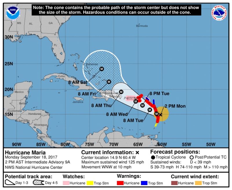
Hurricane and tropical storm warnings and watches were in effect for a string of islands in the area, including the U.S. and British Virgin Islands, Antigua and Barbuda and the French-Dutch island of Saint Martin.
Several of those islands were devastated earlier this month when Irma rampaged through the Caribbean.
French weather service Meteo France issued a red alert for Martinique. Businesses were ordered to shut down, public transport services were suspended and residents were told to take shelter in their houses.
Puerto Rico, a U.S. territory which Irma grazed as it headed toward Cuba and Florida, opened shelters and began to dismantle construction cranes that could be vulnerable to Maria’s high winds.
More than 1,700 residents of Barbuda were evacuated to neighboring Antigua after Irma damaged nearly every building there.
Streets were flooded in some residential parts of the island of Barbados, doused with heavy rain since Sunday as the storm passed to the north of the island.
“We’re not really taking it serious for some of the warnings we get,” said Felicia Waith, a 42-year-old customer service representative at a shipping company in Barbados. “Customers are still coming in. The rain stops, (it’s) business as usual.”
Forecasters were also tracking Category 1 Hurricane Jose, which was carrying 75-mph (120-kph) winds and was located about 265 miles (430 km) east-southeast of Cape Hatteras, North Carolina.
Jose’s center was forecast to remain off the east coast of the United States for the next few days, bringing dangerous surf and rip currents from Delaware through Massachusetts. (Additional reporting by Harriet McLeod in Charleston, South Carolina, Tracy Rucinski in Chicago and Richard Lough in Paris; Writing by Scott Malone; Editing by Alistair Bell and Frances Kerry)
(c) Copyright Thomson Reuters 2017.
Editorial Standards · Corrections · About gCaptain
This article contains reporting from Reuters, published under license.

 Join The Club