Last Minute Brexit Trade Deal Hinges on Fishing Rights
By Marine Strauss and William James BRUSSELS/LONDON, Dec 18 (Reuters) – The European Union said on Friday there were just hours left to strike a Brexit trade deal while Britain called on...

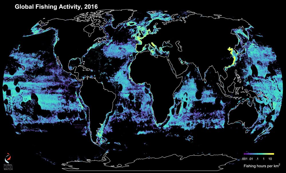
Using satellite tracking, machine learning and common ship-tracking technology, scientists from UC Santa Barbara teamed up with colleagues at Global Fishing Watch, National Geographic Society’s Pristine Sea project, Dalhousie University, SkyTruth, Google and Stanford University to illuminate the extent of global fishing — down to single vessel movements and hourly activity.
![]() By Thin Lei Win ROME, Feb 23 (Thomson Reuters Foundation) – The world’s most comprehensive analysis of shipping data shows industrial fishing is taking place across more than 55 percent of the oceans, with scientists saying the information could help to conserve stocks and assist local fishermen.
By Thin Lei Win ROME, Feb 23 (Thomson Reuters Foundation) – The world’s most comprehensive analysis of shipping data shows industrial fishing is taking place across more than 55 percent of the oceans, with scientists saying the information could help to conserve stocks and assist local fishermen.
By crunching 22 billion messages sent by vessels’ automatic identification systems (AIS) between 2012 and 2016, researchers identified more than 70,000 ships and could pinpoint, among other things, where and for how long they were fishing.
The researchers, who included members from Google and the National Geographic Society, said the study provided “an unprecedented” ability to better manage the oceans’ resources.
“This new real-time data set will be instrumental in designing improved management of the world’s oceans that is good for the fish, ecosystems and fishermen,” said researcher Chris Costello of the University of California Santa Barbara.
Overfishing and illegal fishing by commercial vessels inflict significant damage on fisheries and the environment, and take food and jobs from millions of people in coastal communities who rely on fishing, environmental groups have said.
Global demand for fish is increasing, while nearly 90 percent of world stocks are overfished or fully exploited, the United Nations’ Food and Agriculture Organization (FAO) says.
The study was published in the journal Science on Thursday, and showed that ships fished less in places where stocks were better managed. Researchers said that meant well-enforced policies could combat over-exploitation.
And while most countries fish inside their own exclusive economic zones, it found just five countries – China, Spain, Taiwan, Japan and South Korea – account for 85 percent of fishing on the high seas.
Ships with AIS ping their identity and position every few seconds. But because only large vessels must have AIS, and as parts of the ocean are not covered by satellites, researchers said the true extent was likely higher than 55 percent.
Heavily fished areas include the northeast Atlantic, northwest Pacific and areas off South America and West Africa.
The Southern Ocean, parts of the northeast Pacific and central Atlantic oceans, and the exclusive economic zones of many island states, showed much less activity – which could offer the chance to conserve marine life cheaply.
“The world’s oceans are the ultimate common resource,” David Kroodsma, the study’s lead author and a director at Global Fishing Watch, a project focused on fishing resources, told the Thomson Reuters Foundation by phone.
“They cover 70 percent of the planet, produce half of the oxygen that we breathe and they’re a major protein source for hundreds of millions of people.” (Reporting by Thin Lei Win, Editing by Robert Carmichael; Please credit the Thomson Reuters Foundation, the charitable arm of Thomson Reuters, that covers humanitarian news, women’s rights, trafficking, property rights, resilliance and climate change. Visit http://news.trust.org to see more stories.)
(c) Copyright Thomson Reuters 2018.
This article contains reporting from Reuters, published under license.

Sign up for gCaptain’s newsletter and never miss an update

Subscribe to gCaptain Daily and stay informed with the latest global maritime and offshore news
Essential news coupled with the finest maritime content sourced from across the globe.
Sign Up