Prominent navigational aids on the approach to and within San Francisco Bay have now been inputted for the first time into the electronic aid to navigation (eATON) system. San Francisco is the first port in the United States to begin using such a system.
This doesn’t mean that navigational aids in San Francisco will have electronic transmitters on them however, it’s actually a lot simpler than that.
As the aids to navigation in San Francisco are located in a known, fixed position in the ocean, or on/attached to land, such as the bridge towers of the Golden Gate Bridge, they have their own electronic id assigned to them which is inputted into the AIS system.
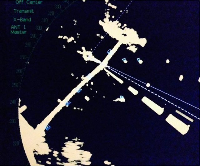
The following image shows what this looks like on a radar console:
Via USCG
As you can see, the center span of the San Francisco-Oakland Bay Bridge is marked by a racon, and the bridge towers themselves are marked by five eATON digital markers.
In addition, eATON currently mark reporting points in the offshore traffic separation scheme (TSS) approaches to San Francisco, the “SF” buoy which serves as the San Francisco Bar Pilot embarkation point, Mile Rocks Light and Harding Rock buoy, which marks a critical turn point for ships in the Central Bay.
A senior Coast Guard official notes that “eATON is not replacing physical aids, but rather this technology is being used to either augment/complement existing physical ATON, or place “virtual” ATON in locations where it may have previously been impractical to do so, such as in water in an offshore TSS which may be too deep for a physical aid, or it’s just not practical or helpful to put a visual day marker on a massive bridge tower, when what you really need is something to help you see it in a low-vis situation).”
Looking ahead, the Coast Guard may look to determine solutions that will allow them to install transmitters on the buoys themselves, which would provide the actual position data of where the buoy actually is, rather than where it is supposed to me.
For those who refuse to use their mark 1 mod 0 eyeball, this may help avoid costly buoy collisions in the future.
The Coast Guard is currently looking for feedback on this new system. Please share your thoughts in the gCaptain Forum HERE.
by John Konrad, K5HIP (gCaptain) Loran-C was an incredibly reliable and accurate analog ground-based navigation system, operated by the US Coast Guard. Despite its impressive performance, it had some drawbacks,...
A group of Bermuda government officials and concerned yachting professionals are warning about recent sightings of at least two large sections of an unlit dry dock reportedly floating off Bermuda....
Lee Chesneau is a senior marine meteorologist, lecturer, & a graduate from the University of Wisconsin (Madison). Lee has had a distinguished career with NOAA’s National Weather Service (NWS), NOAA...
March 7, 2018
Total Views: 158
Get The Industry’s Go-To News
Subscribe to gCaptain Daily and stay informed with the latest global maritime and offshore news
— just like 104,713 professionals
Secure Your Spot
on the gCaptain Crew
Stay informed with the latest maritime and offshore news, delivered daily straight to your inbox
— trusted by our 104,713 members
Your Gateway to the Maritime World!
Essential news coupled with the finest maritime content sourced from across the globe.

 Join The Club