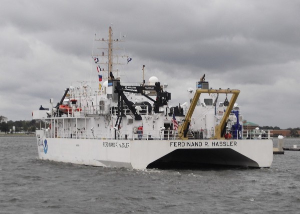
NOAA Ship Ferdinand R. Hassler departed from NOAA’s Marine Operation Center in Norfolk this morning, to start post-SANDY surveys of critical deep water channels.
National Oceanic and Atmospheric Administration (NOAA) meteorologist may finally be able to catch up on sleep as Sandy begins to disappear but the work of other departments within the agency have just started.
NOAA’s Office of Coast Survey navigation response teams and other survey assets are in the water (or soon will be), as they begin checking for underwater debris and shoaling that may pose a risk to navigation. Tasked by the U.S. Coast Guard Captains of the Port, these vessels can use multibeam echo sounders or side scan sonar, as conditions warrant, to search for the answers that would speed resumption of shipping and other vessel movements.
NOAA’s newest survey ship, the Ferdinand R. Hassler, began survey operations Tuesday in support of the U.S. Coast Guard efforts to re-open the Port of Virginia. Hassler was in port at NOAA’s Marine Operations Center – Atlantic in Norfolk, Virginia, for maintenance when Hurricane Sandy affected the area. The ship’s crew spent Monday completing the work and system tests necessary to get underway once the storm passed, and has now been returned to limited operational status.
Lt. Cmdr. Ben Evans, Hassler’s commanding officer, got the ship underway Tuesday, and returned Wednesday evening. The Coast Guard Captain of the Port for Hampton Roads requested that the ship survey critical portions of Thimble Shoal Channel and Chesapeake Channel, the deep draft routes to the ports of Hampton Roads and Baltimore.
“Surveying the deepest draft channels will allow the Coast Guard to decide when to re-open the port to unrestricted traffic without unnecessary delay,” Evans explained. “The ports of the Chesapeake Bay are critical to the U.S. economy and national security, so we need to make this effort as soon as the ship is ready to sail.”
The need for hydrographic surveying is critical. As of yesterday there were 78 large vessels, including portions of the Navy’s Atlantic Fleet, waiting to transit through the entrance to Chesapeake Bay.
The Hassler was also a pivotal survey asset last year, as Hampton Roads resumed operations after Hurricane Irene. At that time, Hassler was one of the three NOAA survey vessels used to clear the port from dangers caused by underwater debris or shoaling. Their work enabled a rapid resumption of shipping and port operations in 2011.
“Delays in shipping, even minor ones, cost the economy millions each year,” explained Rear Admiral Gerd Glang, director of NOAA’s Office of Coast Survey. “After Hurricane Irene last year, NOAA’s rapid maritime response paid dividends in the Hampton Roads area of Virginia, where an average of $5 million worth of cargo is shipped in or out, every hour. This year, rapid response is just as critical.”
The Norfolk Custom District is the country’s 9th largest in terms of the value of total imports and exports moving through the port, with nearly $55 billion in total trade in 2011.
As of Wednesday at noon, other assets of the Office of Coast Survey were responding as follows:
NOAA Ship Thomas Jefferson started out this morning for New York Harbor, where they will survey for obstructions in waterways, starting a daybreak tomorrow. Visual reconnaissance indicates debris and missing containers may pose a danger to shipping.
Navigation Response Team 5 mobilized from Connecticut and got underway in New York at first light this morning, surveying Anchorage Channel. Their next priorities are the route up to the Manhattan cruise ship terminal, Sandy Hook Channel, and then the Global Marine Terminal.
NOAA Ship Ferdinand Hassler spent yesterday and today surveying deep draft ship channels in Chesapeake Channel and Thimble Shoal Channel, as 78 large vessels, including portions of the Navy’s Atlantic Fleet, waited to transit through the entrance to Chesapeake Bay.
NOAA R/V Bay Hydro II is surveying in the Hampton Roads area yesterday and today, checking channels needed by coal shipments and aircraft carriers at Norfolk.
Navigation Response Team 2 is on its way from their regularly scheduled surveying off Florida’s coast, headed to help out in NY/NJ. Additionally, an operations manager is transporting mobile survey equipment to New York, as an additional survey resource on a vessel of opportunity.
NOAA R/V Potawaugh obilized this morning to Lewes, Del., to survey for shoaling that may pose a risk to safe navigation for the Cape May – Lewes Ferry and other vessels. They started surveying, using the multibeam echo sounder, at 1 pm today.
Also on the job is NOAA’s National Geodetic Survey (NGS) begins flying photo survey missions to assess storm damage. The data contained in these photos provide emergency and coastal managers with the information they need to develop recovery strategies, facilitate search-and-rescue efforts, identify hazards to navigation and HAZMAT spills, locate errant vessels, and provide documentation necessary for damage assessment through the comparison of before-and-after imagery.
Currently NGS is coordinating with federal, state, and local officials to conduct remote sensing efforts in response to Sandy. Early this morning, a NOAA King Air aircraft collected imagery of high impact areas of New Jersey from Atlantic City to Cape May on its first flight. On a second flight slated for later today, NOAA’s King Air will focus on areas of better forecast weather along Virginia Beach, Va., south to Cape Hatteras, N.C. A NOAA Twin Otter aircraft is scheduled to depart later today to collect imagery of areas from Ocean City, Md., south to Cape Henry, Va. (including Wallops Island and Chesapeake Bay Bridge Tunnel).
Editorial Standards · Corrections · About gCaptain

 Join The Club