By Kendra Pierre-Louis and Brian K Sullivan (Bloomberg) —
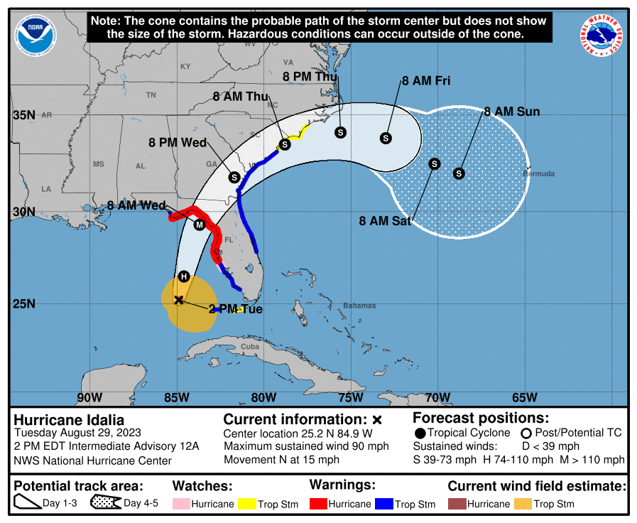
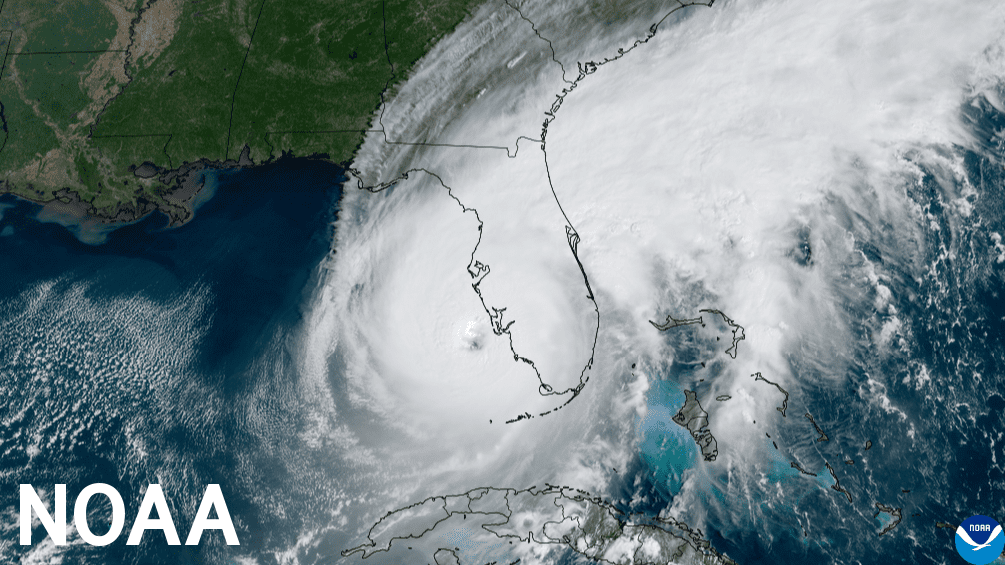
Hurricane Idalia, now a Category 1 storm, is expected to make landfall along Florida’s Gulf Coast on Wednesday. The hurricane’s likely transformation between now and then will be due in part to the unusually warm waters on its path.
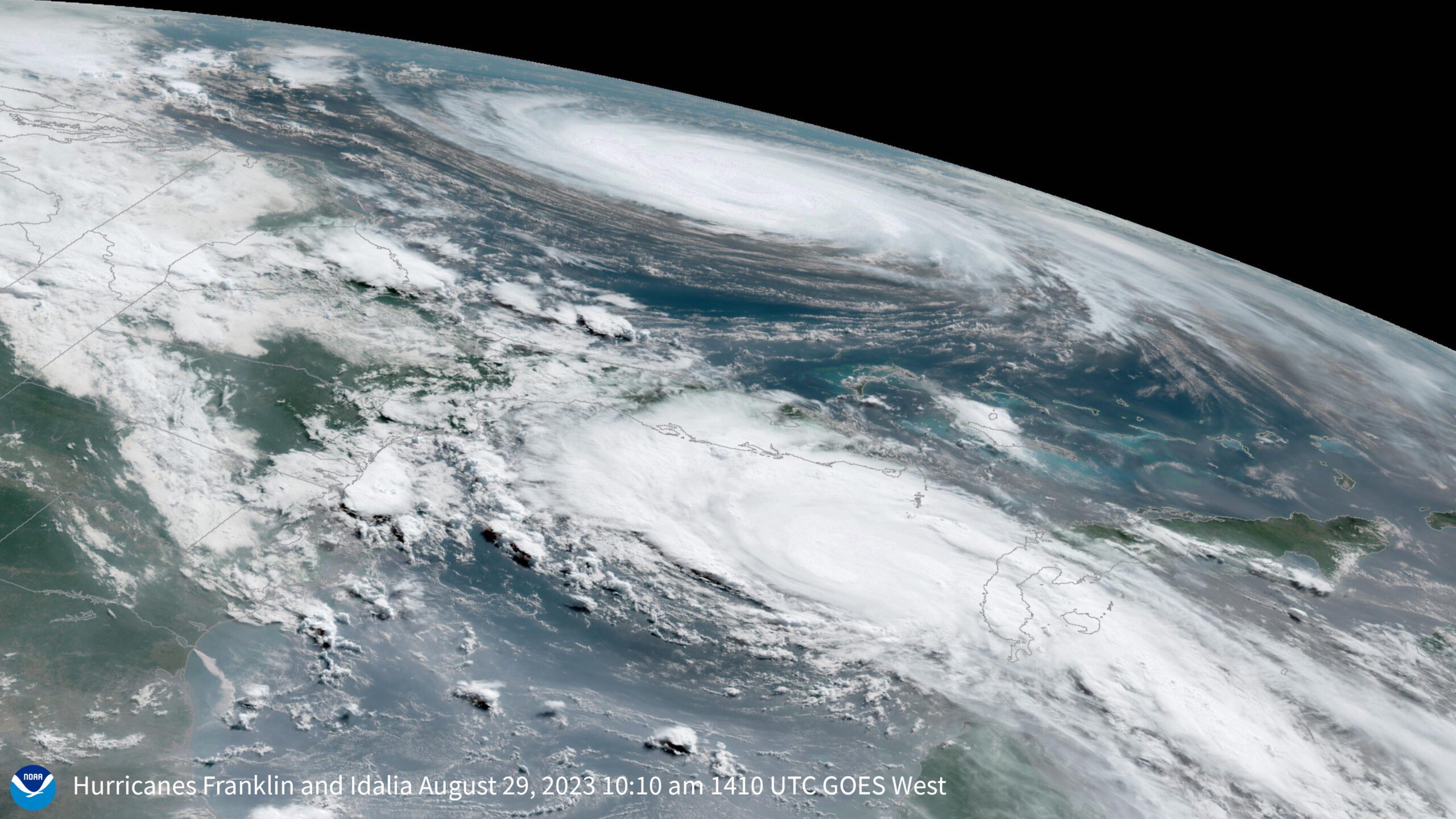
As of 11 a.m. Eastern on Tuesday, Idalia had winds of 85 miles (137 kilometers) per hour and was churning northeast, just past the tip of Cuba. Between it and Florida sit 200 miles of uninterrupted sizzling ocean. Water temperatures along the storm’s predicted track are close to 90F (32C), reflecting record ocean warmth — a hallmark of climate change — in the Gulf of Mexico. The water isn’t just hot on the surface; the heat extends more than 100 feet below.
That’s a prime setup for what’s known as rapid intensification, a phenomenon where a storm’s wind speed increases at least 35 mph (56 kph) within 24 hours. The US National Hurricane Center forecasts that Idalia will rapidly intensify between Tuesday and Wednesday, reaching Category 3 strength as it makes landfall.
Warm water acts as hurricane fuel. Water evaporates more easily at higher temperatures, releasing more energy into the atmosphere. The more moisture, the more catastrophic a storm can become.
A hurricane is essentially “a heat engine,” said James P. Kossin, an atmospheric scientist with the University of Wisconsin-Madison and the flood risk nonprofit First Street Foundation. Its input is “mostly water vapor coming off the surface of the ocean,” not unlike the steam that rises when you heat water in a pan.
Or as Phil Klotzbach, lead author of the Colorado State University seasonal hurricane forecast, put it, the extra hot waters are essentially “rocket fuel.” That’s in part due to climate change, which “loads the dice and shifts the tails of distribution.”
Research has shown that hurricane wind speeds can increase about 5% for every 1C increase in ocean temperature, said Jeff Masters, a meteorologist at Yale Climate Connection. A 5% increase in wind speed translates to a 50% increase in the storm’s destructive potential. The water in the Gulf of Mexico is currently 1C to 2C degrees above normal, which means Idalia could be 50% to 100% more destructive than it would have been in a year with average sea surface temperatures, he added.
The staggering depth of the hot water is also a huge red flag for Idalia’s forecast. “It is really crazy to look at the depth profile,” Masters said. “The amount of warm water is so deep.” This is important because hurricanes churn up the surface as they move; if the storm pulls up cold water, it can weaken itself. With hot water extending 120 feet deep, that’s unlikely.
Climate change has turned up the heat in oceans around the globe. This summer, though, the trend has been particularly pronounced. Hurricane Franklin, the year’s first major Atlantic hurricane, rapidly intensified amid the same hot waters between Sunday and Monday, and is expected to pass to the west of Bermuda on Wednesday. The island is currently under a tropical storm watch.
Rapid intensification is difficult to forecast and can often take officials and residents by surprise, making planning and executing evacuations more difficult. But a growing body of research suggests that, by increasing ocean temperatures, climate change is making rapid-intensification events more common. One study published in Nature Communications this year found that rapid-intensification events worldwide tripled between 1980 and 2020 in offshore areas within 400 kilometers (250 miles) of coastline.
Research looking at the Atlantic Ocean specifically identified a similar trend. An Associated Press analysis of National Hurricane Center data found that, between 2017 and 2021, there had been 30 rapidly intensifying storms in the Atlantic and 32 in the Pacific, roughly 25% more than 40 years earlier. A study published in Geophysical Research Letters last year found that the rate of rapid intensification increased near the US Atlantic coast between 1979 and 2018. The researchers noted that their projections suggest “a continued enhancement of the storm environment and hurricane intensification near the Atlantic coast in the future.”
Unusually warm water is only one ingredient in the complex recipe for hurricanes. If the air is dry or the upper-level winds are strong, storms can have trouble forming. That’s one reason this year’s Atlantic hurricane season has been relatively mild until now. Florida had unusually warm waters for much of this summer, but Kossin noted that the atmosphere was too hostile for hurricanes to form. Those conditions have shifted over the past few weeks.
Normally a strong El Niño, like the one currently affecting the tropical Pacific, tamps down Atlantic hurricane activity by increasing upper level winds — removing some of a hurricane’s fuel. But this El Niño “has been battling this phenomenally warm water” in the Gulf of Mexico and Atlantic, Kossin said.
Earlier this month, the National Oceanic and Atmospheric Administration updated its Atlantic hurricane season forecast from average to above average because “we were starting to get some storms forming, even in these hostile environments, because the water was so warm,” said Kossin.
In Florida, residents are preparing for an expected landfall on Wednesday, with up to 12 feet of storm surge predicted for some regions. Governor Ron DeSantis has declared an emergency for 46 counties and President Joe Biden has approved federal emergency declarations for Florida. More than 12 counties have issued evacuation orders.
© 2023 Bloomberg L.P.
Editorial Standards · Corrections · About gCaptain
This article contains reporting from Bloomberg, published under license.

 Join The Club