Editorial Note: This is a NASA photo from September. 9th. Click HERE for the latest news on Typhoon Chanthu.
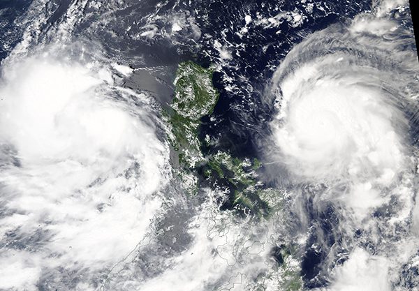
Twin storms flanked the northern Philippines on September 9, 2021, each threatening the islands with strong winds, torrential rains, and dangerous storm surge. The Moderate Resolution Imaging Spectroradiometer (MODIS) on board NASA’s Aqua satellite acquired this true-color image of the green islands caught between Tropical Storm Conson (west) and Typhoon Chanthu (east).
Tropical Storm Conson, also known as Jolina, first spun up as a tropical depression well east of the Philippines on September 5. Late on September 6, the Philippine Atmospheric, Geophysical, and Astronomical Services Administration (PAGASA) reported that the storm had rapidly intensified to a typhoon and make landfall in Eastern Samar, Philippines.
Maximum sustained winds were close to 75 mph (120 km/h) at that time. As the storm moved westward, it made additional landfalls before leaving the islands and entering the West Philippine Sea on September 9. At that time, Tropical Storm Conson was carrying maximum sustained winds of about 59 mph (95 km/h). Media reports after the passage of the storm reported power outages on the islands but minimal damage.
Typhoon Chanthu, also called Kiko in the Philippines, first became a tropical depression in the early afternoon on September 6, 2021. Within 48 hours, it had increased to super typhoon strength. Wind speeds accelerated from 50 kilometers (30 miles) per hour to 260 kilometers (160 miles) per hour. NASA’s Earth Observatory states that, according to NOAA scientist Sam Lillo, only five storms on record have intensified at such a rate.
By 11 p.m. Philippine Standard Time on September 9, the typhoon was about 550 kilometers (300 nautical miles) east-northeast of Manila, with sustained winds of 220 kilometers (140 miles) per hour. Significant wave heights in the open ocean were approaching 14 meters (45 feet). Although Chanthu was a compact system as it passed the Philippines, wind gusts of up to 155 mph (250 km/h) were reported over the islands.
Late on September 11, the Joint Typhoon Warning Center advised that Typhoon Chanthu was located about 391 miles (629 km) west-southwest of Kadena Air Base and was tracking north-northeastward. The storm was approaching Taiwan, with the center likely remaining just off the eastern coast on September 12 as it makes its way to a landfall on mainland China.
On September 11, Tropical Storm Conson had weakened to a tropical depression as it tracked northwestward in the South China Sea close to the coast of central Vietnam. It is expected to make landfall over northern Quang Nam Province, Vietnam, early on September 13.
This article originally appeared on NASA’s website under the title ‘September 12, 2021 – Tropical Storm Conson and Typhoon Chanthu’
Editorial Standards · Corrections · About gCaptain

 Join The Club