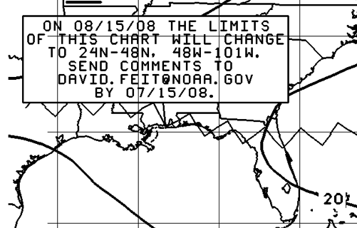
The above shows a notice box on NOAA’s current 24hr Surface Prediction Chart which can be found HERE. It states:
On 08/15/08 the limits of this chart will change to 24N-48N, 48W-101W. Send comments to [email protected] by 07/15/08
Notice on the live version of this chart Hurricane Bertha and the area of low pressure to her Northeast are both outside the proposed limits! Here at gCaptain we consider this a degradation of service not a simple adjustment of scale and are supprised by this move from an otherwise rational government organization. It is our opinion that the boundries of this chart should instead be increased to cover the entire North Atlantic which would bring it inline with NOAA’s 48 and 96 hour prediction charts (view all charts HERE)!
Please leave your comments regarding this change bleow and we will be sure they get fowarded on to Mr. Feit and our contacts at NOAA.
Updated: February 5, 2026 (Originally published July 8, 2008)
Editorial Standards · Corrections · About gCaptain

 Join The Club


