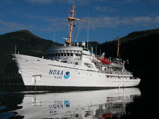
NOAA Ship Fairweather sets sail to map areas of the Arctic
 NOAA Ship Fairweather, a 231-foot survey vessel, departed Kodiak, Alaska, today on a mission to conduct hydrographic surveys in remote areas of the Arctic where depths have not been measured since before the U.S. bought Alaska in 1867.
NOAA will use the data to update nautical charts to help mariners safely navigate this important but sparsely charted region, which is now seeing increased vessel traffic because of the significant loss of Arctic sea ice.
Over the next two months, Fairweather will conduct hydrographic surveys covering 402 square nautical miles of navigationally significant waters in Kotzebue Sound, a regional distribution hub in northwestern Alaska in the Arctic Circle.
“The reduction in Arctic ice coverage is leading over time to a growth of vessel traffic in the Arctic, and this growth is driving an increase in maritime concerns,” explained NOAA Corps Capt. David Neander, commanding officer of the Fairweather. “Starting in 2010, we began surveying in critical Arctic areas where marine transportation dynamics are changing rapidly. These areas are increasingly transited by the offshore oil and gas industry, cruise liners, military craft, tugs and barges, and fishing vessels.”
Fairweather and her survey launches are equipped with state-of-the-art acoustic technology to measure ocean depths, collect 3-D imagery of the seafloor, and detect underwater hazards that could pose a danger to surface vessels. The ship itself will survey the deeper waters, while the launches work in shallow areas.
The city of Kotzebue, located on the shores of Kotzebue Sound at the tip of Baldwin Peninsula, serves as a supply hub for eleven Arctic villages and cannot currently accommodate deep draft vessels. Those vessels must now anchor 15 miles offshore, and cargo is brought to shore by shallow draft barges. This summer’s survey will also address a request for bathymetry to support navigation and installation for an offshore lightering facility used for heating and fuel oil. An up-to-date NOAA chart, using data acquired from surveys with modern high-resolution sonar technology, can improve the efficiency – and safety – at this important location.
Modern U.S. navigational charts are the best in the world, and are updated regularly by NOAA’s Office of Coast Survey. However, they are only as good as the data available, and many of the soundings on today’s Arctic charts were acquired in the 1800’s with a weighted lead line, an antiquated technique. In addition to surveying critical areas with modern multibeam sonar technologies, NOAA has initiated a major effort to update nautical charts that are inadequate for today’s needs, such as the deep draft vessels looking to exploit an open trade route through the Arctic. NOAA’s Arctic Nautical Charting Plan, issued last month, prioritizes charts that need updating.
“NOAA’s Arctic surveys and charting plan identify the additional hydrographic coverage necessary to support a robust maritime transportation infrastructure in the coastal areas north of the Aleutian Islands,” said NOAA Corps Capt. Doug Baird, chief of NOAA’s Marine Chart Division in the Office of Coast Survey. “With the resources we have available, we are building the foundation to meet the burgeoning demands of ocean activities around Alaska’s waterways.”
Fairweather, one of NOAA’s three ships dedicated to hydrographic surveying, is part of the NOAA fleet of research ships operated, managed and maintained by NOAA’s Office of Marine and Aviation Operations, which includes commissioned officers of the NOAA Corps, one of the seven uniformed services of the United States, and civilian wage mariners. The public can track the ship’s progress by visiting the NOAA Ship Tracker.
NOAA’s Office of Coast Survey, originally formed by President Thomas Jefferson in 1807, updates the nation’s nautical charts, surveys the coastal seafloor, responds to maritime emergencies and searches for underwater obstructions and wreckage that pose a danger to navigation.
NOAA’s mission is to understand and predict changes in the Earth’s environment, from the depths of the ocean to the surface of the sun, and to conserve and manage our coastal and marine resources. Join us on Facebook, Twitter and our other social media channels.
On the Web:
NOAA’s Arctic Nautical Charting Plan:
http://www.nauticalcharts.noaa.gov/mcd/docs/Arctic_Nautical_Charting_Plan.pdf
NOAA’s Hydrographic Survey Priorities (See “Projects for 2011”):
http://www.nauticalcharts.noaa.gov/hsd/hydrog.htm
Source: NOAA

Subscribe for Daily Maritime Insights
Sign up for gCaptain’s newsletter and never miss an update
— trusted by our 109,087 members

Get The Industry’s Go-To News
Subscribe to gCaptain Daily and stay informed with the latest global maritime and offshore news

 Join The Club


