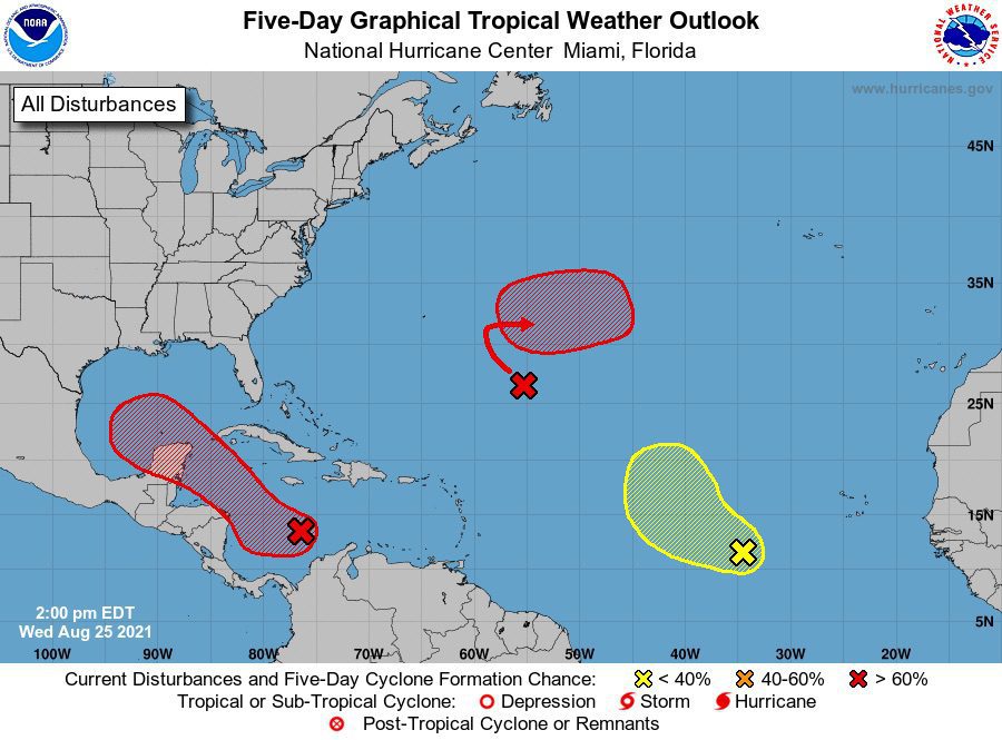
The National Weather Services’s National Hurricane Center says it is closely watching a broad area of low pressure that is forecasted to track into the Gulf of Mexico where conditions are ripe for further development.
The system is expected to develop further over next day or so in the southwestern Caribbean Sea where it is likely to form into a tropical depression or tropical storm late this week or this weekend. It is expected to move northwestward over the northwestern Caribbean Sea and near or across the Yucatan Peninsula of Mexico on Friday and into the Gulf of Mexico this weekend where conditions are expected to be favorable for additional development.
However, the NHC notes that there remains “large” uncertainty since the system has yet to form.
“Regardless of development, heavy rainfall and flooding will be possible through the weekend in portions of Nicaragua, Honduras, Guatemala, Belize, and the Yucatan Peninsula,” the National Hurricane Center said a 2 p.m. ET update. “In addition, this system could bring dangerous impacts from storm surge, wind, and heavy rainfall to portions of the coasts of Louisiana, Texas, and the Mexican state of Tamaulipas late this weekend and early next week.”
The NHC says interests in these areas should closely monitor the progress of this system and ensure they have their hurricane plan in place. An Air Force Reserve reconnaissance aircraft is scheduled to investigate the system Thursday afternoon, if necessary.
After a busy start to this year’s hurricane season, NOAA earlier this month issued its annual mid-season outlook which was upgraded to reflect the agency’s estimate of 15 to 21 named storms, including 7 to 10 hurricanes and 3 to 5 major hurricanes (Category 3, 4, or 5 with winds 111 mph or greater). The updated outlook includeed the 5 named storms that had formed so far year (to date as of the upgrade), with Hurricane Elsa becoming the earliest 5th named storm on record. Hurricane Henri, which hit the Northeast on Sunday as a tropical storm, was the eighth named storm.
Last year’s record-breaking Atlantic hurricane season dealt a serious blow to Gulf of Mexico energy production, with 30 named storms (you may recall going to the Greek alphabet named storms), of which 13 became hurricanes including six major hurricanes. This marked the most storms on record, surpassing the previous 2005 record of 28 named storms.
In addition to the area of disturbance mentioned above, the National Hurricane Center said it is also watching two additional areas of low pressure in the Atlantic basin, including one central tropical Atlantic about 700 miles southeast of Bermuda, which is not expected to develop, and another over the far eastern tropical Atlantic located several hundred miles southwest of the Cabo Verde Islands. With the latter system, the NWS NHC says some development is possible over the next several days as it moves west-northwestward at 10 to 15 mph over the eastern tropical Atlantic.
Check the NOAA NWS National Hurricane’s facebook page and website for the latest forecasts.
Editorial Standards · Corrections · About gCaptain

 Join The Club