Was The World’s ‘Northern-Most Island’ Erased From Charts?
by Kevin Hamilton (University of Hawaii) In 2021, an expedition off the icy northern Greenland coast spotted what appeared to be a previously uncharted island. It was small and gravelly,...


By Captain Patrick Donovan, R/V Thomas G. Thompson, University of Washington
As mariners we encounter them all the time… a yellow buoy, a white ship, the daily routine of transmitting weather observations. They are references to scientific research taking place in our world, a world habitually focused on trade, commerce, profit, and loss. Sometimes unnoticed, the commercialized aspect of life on the sea comes in contact with the academic pursuit of knowledge.
Often these references arrive in the form of a Notice to Mariners. An update to a chart, a submerged mooring, plotted somewhere along our track line. A concern? Maybe. But then you see the depth, 2600 meters. Your deeply laden vessel only draws 12m. No problem.
But what is this mooring, and why would someone put it there? What is so interesting at that depth that someone would travel out into the middle of nowhere, a place that in normal seagoing life is often part of a route but never a destination, and install a subsea mooring in 2600 meters of water?
The answer is almost infinite. Ocean waves, swell, temperature, sea life, chemical makeup of the water column, salinity, gravity, motion, oxygen, nitrates, sediment, etc. You name it, and there is an instrument for it, or at least one in development. The ocean environment is still so vastly unknown, there are new and unexplainable things happening on a daily basis. We know more about the moon than we know about our own ocean, and in turn have a shared responsibility to find out more.
Though it can be one of the most tranquil, docile, and beautiful environments, the ocean can in a matter of minutes turn into one of the harshest, most unforgiving places on earth. Our ability to understand and predict weather patterns on the surface has led to increased safety for mariners by 100 fold, but understanding the weather is only part of the problem. We don’t have, and never will have the ability to control it. And thus lies the greatest challenge in attempting to study a particular region. Access.


The only available access to the ocean is by ship, and the types of vessels needed are few and far between. Oceanographic research vessels must be seagoing vessels capable of handling large parties of scientific personnel, and hosting a variety of equipment, including remotely operated vehicles (ROV’s) and manned submersibles. They are expensive to operate, and offer little profit for commercial operators.
Scientists spend years writing grants, fighting for ship time, mobilizing a small army’s worth of equipment to remote outcroppings of ports to meet an available ship, transit out to the site of interest, only to be thwarted by impersonal and unbiased nasty weather.
A group of researchers from the University of Victoria, British Columbia, have found a solution to this issue by building a remote underwater ocean observatory.
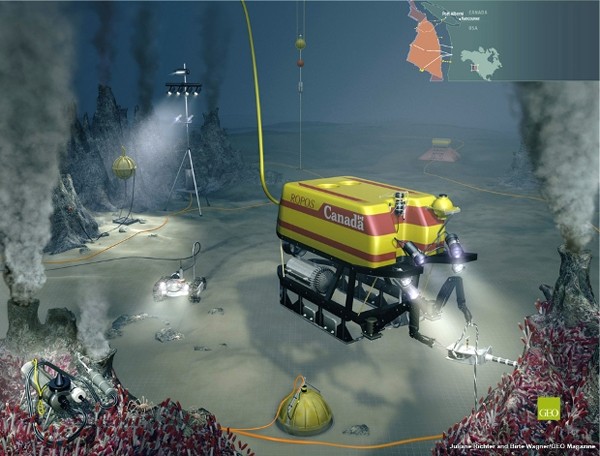
Ocean Networks Canada (ONC) consists of two-subsea cable networks- called Venus (inshore) and Neptune (offshore). Located off the coast of Vancouver Island, these networks entail groups of instruments linked together by fiber optic cables. The network uses the power of the Internet to bring real time observations from underwater instruments right into the offices and classrooms of researchers around the world, regardless of the weather.
Some of the instrument types of instruments available to date include:
The network offers early warning for potential disasters, such as earthquakes and tsunami’s. The hope is that with these instruments in place, the data will be available in the future to understand and predict such phenomena.


There is even a remotely operated crawler with HD video, lights, and all different types of sensors, that can be driven around from a shore-side control station in Germany. This miniature bulldozer – named Wally due to its resemblance to the Disney Pixar’s Wall-E, resides on the end of a 30m tether, and provides researchers with mobile access to his realm “wally land”.
The primary installation of the fiber optic main line was done by commercial cable ships, working under contract similar to that of a phone company. The auxiliary lines, instruments, and nodes have been installed by oceanographic research vessels, using an ROV to map out and survey cable routes, install instruments, and lay cable.
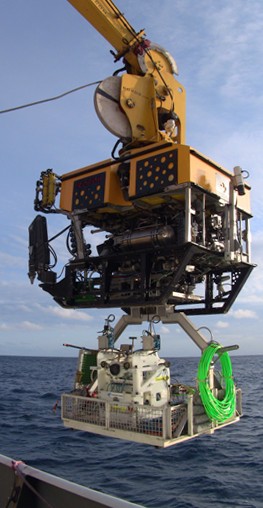
The Canadian Scientific Research Facility’s ROV-named ROPOS has done the bulk of the installation and maintenance. ROPOS has the ability to latch on to instrument platforms and fly them down to the sea floor to be plugged in to the network. It also has the ability to lay cable using an innovative system called ROCLS, or Remote Operated Cable Laying System. ROCLS is essentially spool of wire in a specialized geared frame designed to attach to the bottom of the ROV. The ROV can fly along with the cable reel and pay it out as they go, laying the cable along a pre-determined path on the sea floor.
The instruments are designed to be plug and play. They use wet-mate connectors (which look like children’s toys made by Nerf) that can be plugged in by an ROV, allowing the instrument to be easily removed for maintenance/updating, and/or moved to other areas of the network.
The ability to change out and add additional instrumentation is a significant component of these systems. This is what will allow the networks to grow and evolve as interests and focuses change. The scientific process can be very dynamic, in that the course of the research will often change as more is discovered and understood about a particular subject.
Now in its second year of operation, ONC has gone through its share of trials and tribulations. Cable and instrument failures have beleaguered the network. The system requires annual maintenance, thus requiring ship time. Ultimately though, they have been successful. There has been a great deal of interest in further developing instrumentation and data collection, and the hope is that over time the network will become more interactive.
In the United States, the National Science Foundation is in the process of installing a similar network of instrumentation through its Ocean Observatories Initiative (OOI). The objective is to create an expansive network following the NEPTUNE concept, over time encompassing the oceans of the western hemisphere. There are multiple research institutions taking place in the implementation of OOI, each taking charge of a critical piece of the infrastructure. The networks will be high power and bandwidth, streaming real time observations, data, and live HD video. They will provide long-term access to an environment where up until recently, only a glimpse has been available.
Like anything else, these networks will evolve over time, with lessons learned and changes brought about by technology and innovation. The concept is sound, and the results proven. The research community has come a long way from the bathyscaphe and the Aqualung, and even the submersible. These tools, while still significant part of the foundation of oceanography, are dwarfed by the shear enormity of potential for the future of cabled observatories.
For more information on this project please watch the following TEDx presentation:
Or visit:
Join the gCaptain Club for curated content, insider opinions, and vibrant community discussions.


Join the 105,932 members that receive our newsletter.
Have a news tip? Let us know.
Access exclusive insights, engage in vibrant discussions, and gain perspectives from our CEO.
Sign Up


Maritime and offshore news trusted by our 105,932 members delivered daily straight to your inbox.


Essential news coupled with the finest maritime content sourced from across the globe.
Sign Up