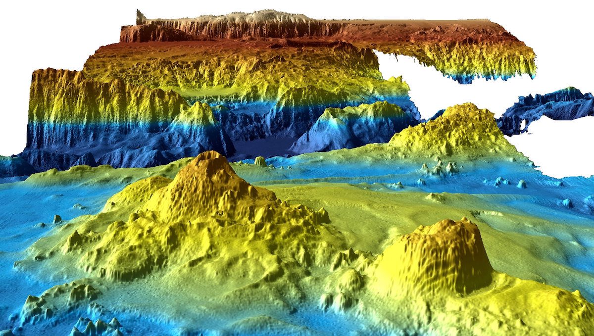
An undated supplied image from Geoscience Australia shows a computer generated three-dimensional view of the sea floor obtained from mapping data collected during the first phase of the search for missing Malaysia Airlines flight MH370. Commonwealth of Australia (Geoscience Australia)/Handout via REUTERS
By Tom Westbrook and Jonathan Barrett SYDNEY, July 19 (Reuters) – Detailed sea-floor maps made during the unsuccessful search for missing Malaysia Airlines Flight MH370, released by Australia on Wednesday, could help increase the knowledge of rich fisheries and the prehistoric movement of the earth’s southern continents.
The Indian Ocean search ended in January after covering a lonely stretch of open water where under-sea mountains larger than Mount Everest rise and a rift valley dotted with subsea volcanoes runs hundreds of kilometers long.
The whereabouts of the plane, which vanished in March 2014 en route to Beijing from Kuala Lumpur with 239 people on board, remains one of the world’s greatest aviation mysteries.
However, information gathered during painstaking surveys of some 120,000 sq km (46,000 sq miles) of the remote waters west of Australia should provide fishermen, oceanographers and geologists insight into the region in unprecedented detail, said Charitha Pattiaratchi, professor of coastal oceanography at the University of Western Australia.
“There are the locations of seamounts which will attract a lot of international deep sea fishermen to the area,” Pattiaratchi told Reuters by phone.
High-priced fish such as tuna, toothfish, orange roughy, alfonsino and trevally are known to gather near the seamounts, where plankton swirl in the currents in the inhospitable waters.
Pattiaratchi said the location of seamounts would also help model the impact of tsunamis in the region, given undersea mountains help dissipate their destructive energy, and potentially change our understanding of the break-up of the ancient supercontinent of Gondwana.
The data consists of three-dimensional models of undersea landforms as well as raw bathymetric survey information. It was published online by Geoscience Australia on Wednesday, with a further tranche due to be published next year.
“It is estimated that only 10 to 15 percent of the world’s oceans have been surveyed with the kind of technology used in the search for MH370, making this remote part of the Indian Ocean among the most thoroughly mapped regions of the deep ocean on the planet,” said Stuart Minchin, chief of Geoscience Australia’s environmental geoscience division.
Australia has not ruled out resuming the search for the Boeing 777 airliner but has said that would depend on finding “credible new evidence” about the plane’s whereabouts.
“No new information has been discovered to determine the specific location of the aircraft and the underwater search remains suspended,” Australian Transport Minister Darren Chester said in a statement on Wednesday.
(Reporting by Tom Westbrook and Jonathan Barrett; Editing by Paul Tait)
More than a decade after Malaysia Airlines Flight MH370 vanished with 239 people aboard, a renewed search effort has officially begun in one of the world’s most remote maritime regions,...
By Isla Binnie (Reuters) – For the next four months, robotic submersible vehicles will swim the frigid, choppy waters around South Georgia island, gathering evidence to determine whether a massive...
By Angus Whitley and Anisah Shukry (Bloomberg) — The search for Malaysia Airlines Flight 370 is in peril once again as new Prime Minister Mahathir Mohamad reins in government spending....
May 24, 2018
Total Views: 67
Get The Industry’s Go-To News
Subscribe to gCaptain Daily and stay informed with the latest global maritime and offshore news
— just like 106,037 professionals
Secure Your Spot
on the gCaptain Crew
Stay informed with the latest maritime and offshore news, delivered daily straight to your inbox
— trusted by our 106,037 members
Your Gateway to the Maritime World!
Essential news coupled with the finest maritime content sourced from across the globe.

 Join The Club