Updated: December 5, 2023 (Originally published February 20, 2018)
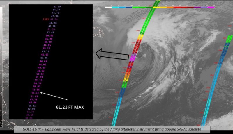
A satellite pass observes a max significant wave height of 61.23 feet in the North Atlantic on Tuesday, February 20, 2018. Credit: NOAA
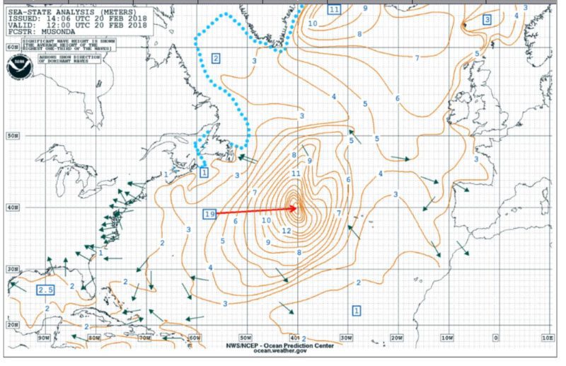
An intense low pressure system in the North Atlantic was producing significant wave heights of an incredible 19 meters (62 feet) on Tuesday, according to the National Weather Service.
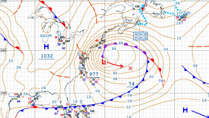
This is a very dangerous storm with hurricane force winds and extreme waves in some of the main shipping lanes between Europe and the United States.
NOAA NWS Ocean Prediction Center has been monitoring the system over the last few days and watched as it rapidly intensified overnight Saturday, developing hurricane force winds in excess of 64 knots by Sunday morning as forecast.
The latest NOAA OPC analysis now shows a frightening max significant wave height of 19 meters, up slightly from 18.3 meters (60 feet) detected earlier Tuesday. That’s the equivalent of a six-story building.
At these heights, this storm could set a new wave height record for this part of the Atlantic.
NOAA OPC significant wave height analysis shows an incredible max significant wave of 19 meters (62 feet) over the N Atlantic on February 20, 2018 at 1200 UTC.
This storm poses an extreme danger to ships at sea as it has tracked eastward at a fairly low latitude over some of the main shipping channels connecting North Europe and Mediterranean ports and US East Coast and Gulf ports.
Keep in mind, significant wave height is the average height of the tallest one-third of waves (from trough to crest), so individual waves are likely to be much, much bigger.
The good news, however, is this monster is forecast to weaken rapidly over the next 24 hours.
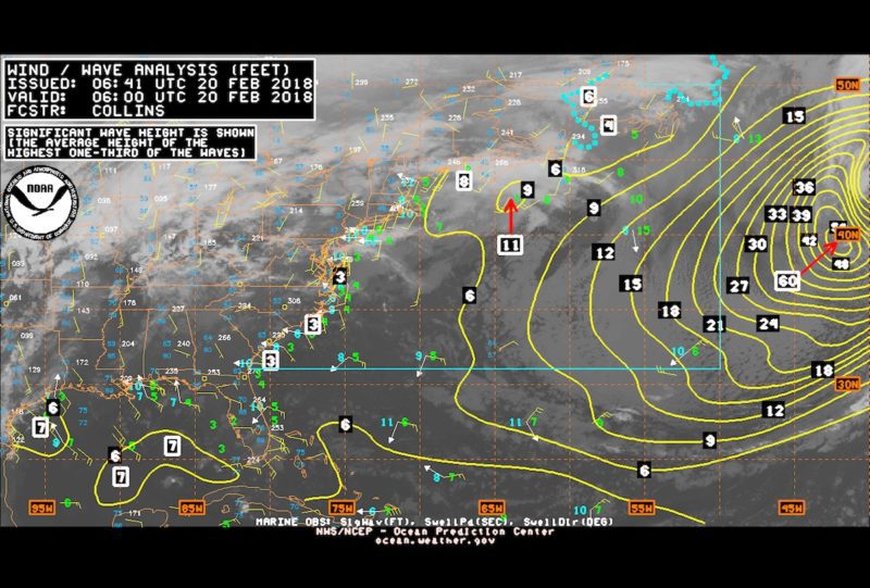
A NOAA OPC wave height analysis shows significant waves of 18.3 meters (60 feet), February 20, 2018 at 06:00 UTC
Updated: September 7, 2018 (Originally published September 4, 2018) https://www.youtube.com/watch?v=SKBLdXlezvg A tanker smashed into the bridge linking Japan’s Kansai International Airport with the mainland on Tuesday as a powerful typhoon...
Updated: January 9, 2024 (Originally published March 28, 2018) https://www.youtube.com/watch?v=YwDQF4rs3JY Check out this a new time-lapse video released by NOAA showing the four back-to-back nor’easter winter storms that impacted the...
Updated: March 8, 2018 (Originally published March 7, 2018) Lee Chesneau is a senior marine meteorologist, lecturer, & a graduate from the University of Wisconsin (Madison). Lee has had a...
March 7, 2018
Total Views: 152
Get The Industry’s Go-To News
Subscribe to gCaptain Daily and stay informed with the latest global maritime and offshore news
— just like 107,230 professionals
Secure Your Spot
on the gCaptain Crew
Stay informed with the latest maritime and offshore news, delivered daily straight to your inbox
— trusted by our 107,230 members
Your Gateway to the Maritime World!
Essential news coupled with the finest maritime content sourced from across the globe.

 Join The Club