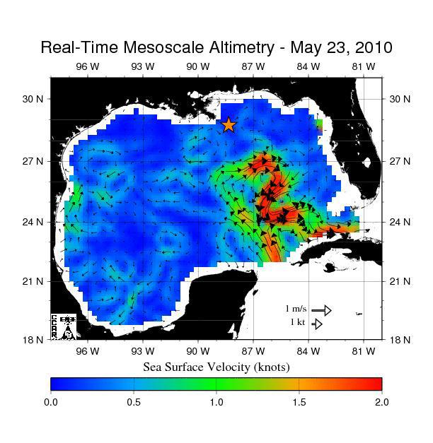
Scientists and agencies monitoring the oil spill in the Gulf of Mexico are keeping a wary eye on changes in the nearby Loop Current, a warm ocean current that is part of the Gulf Stream. Beginning as a large flow of warm water from the Caribbean, the Loop Current heads up into the eastern part of the Gulf of Mexico and then turns south before finally moving out through the Straits of Florida and northward into the Gulf Stream. Deep and fast moving, the Loop Current often breaks off and forms strong, clockwise rotating eddies called anticyclones that travel westward into the Gulf. The currents along the outer edges of the Loop Current, as well as these eddies, have been clocked at speeds as high as three to four knots (three to five miles per hour), comparable to the fastest ocean currents ever observed.
Because the Loop Current and its eddies are warmer, and thus higher in surface elevation, than the surrounding waters, they are easily spotted by satellite altimeters, such as those aboard the NASA/French Space Agency Jason 1 and Ocean Surface Topography Mission/Jason 2 satellites. Scientists use the latest satellite measurements of sea-surface height from these and other satellite altimeters to create maps showing the location, direction and speed of currents in the Gulf of Mexico.
This image, created on May 23, 2010, using measurements of sea surface height from multiple satellites, including Jason-1 and OSTM/Jason-2, shows the speed and direction of surface currents in the Gulf. The northern portion of the Loop Current, shown in red, appears about to detach and form a separate eddy–a large, warm, clockwise-spinning vortex of water that is the ocean’s version of a cyclone. The star shows the former location of the Deepwater Horizon drilling rig that exploded and sank in April, and has been leaking oil since. Scientists believe a large eddy between the oil spill and the Loop Current could keep, at least temporarily, some of the spilling oil from reaching the Florida Straits and the Gulf Stream.
This map was produced by the Colorado Center for Astrodynamics Research in Boulder, Colo. The center processes satellite measurements of sea surface height in near real-time to create maps of the Gulf of Mexico, showing the location of medium-sized eddies and fronts. More information on these data products is available at http://argo.colorado.edu/~realtime/welcome/.
Source: NASA
Updated: February 5, 2026 (Originally published May 25, 2010)
Editorial Standards · Corrections · About gCaptain

 Join The Club


