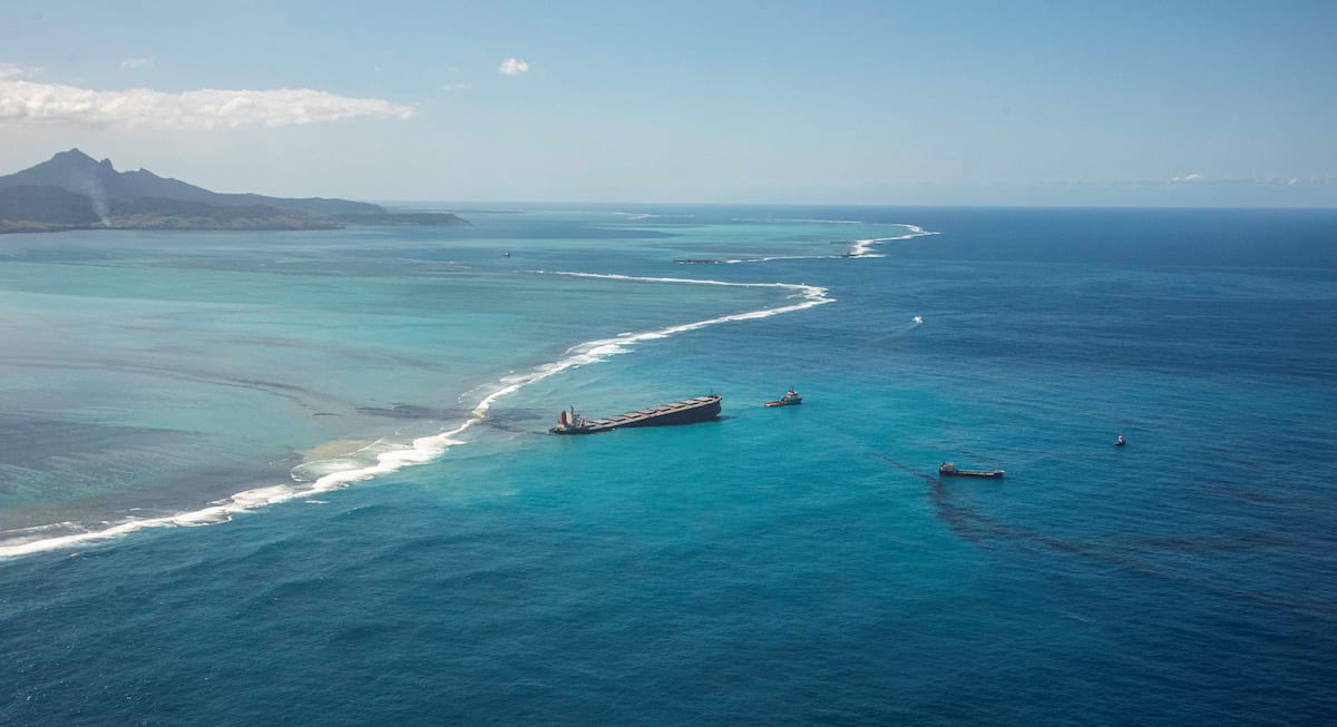
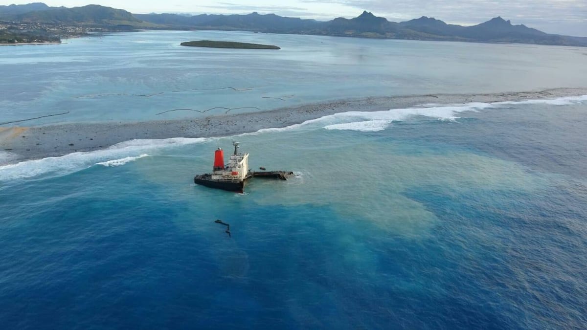
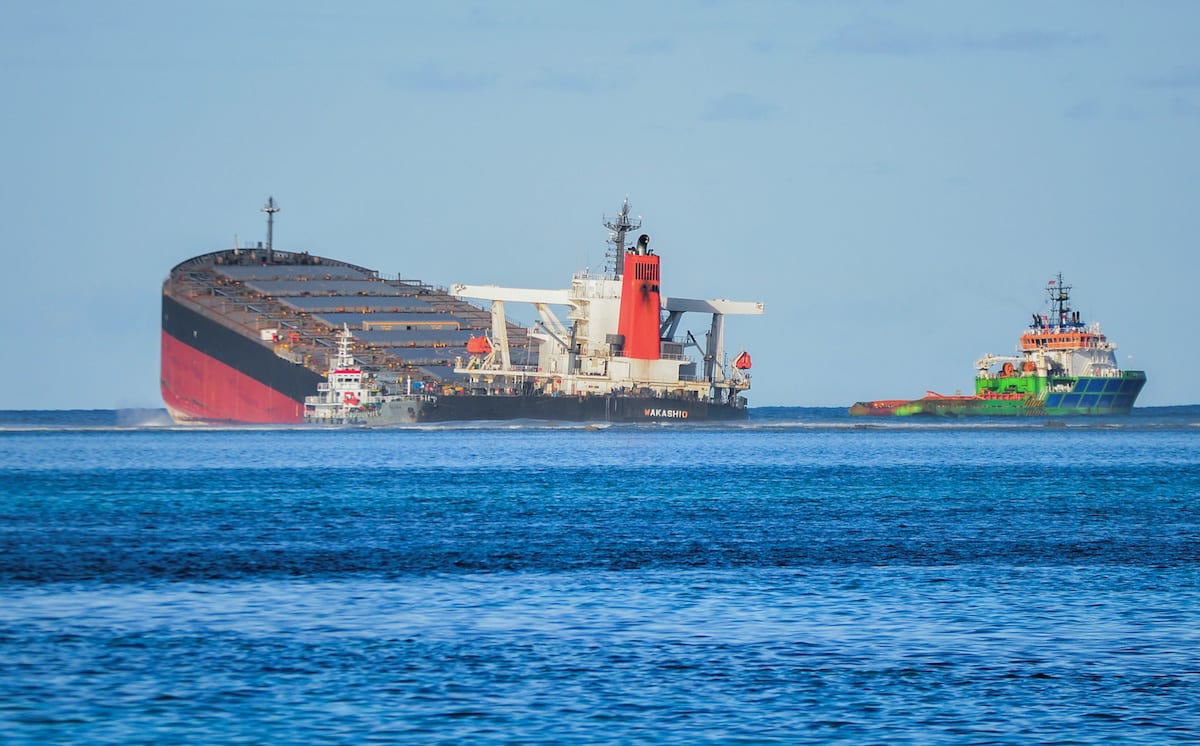
A general view shows the bulk carrier ship MV Wakashio, belonging to a Japanese company but Panamanian-flagged, that ran aground on a reef, at the Riviere des Creoles, Mauritius, August 11, 2020. REUTERS/Sumeet Mudhoo/L’Express Maurice
By Julian Lee and Adeola Eribake (Bloomberg) — The bulk carrier Wakashio was 11 days into a month-long voyage to Brazil when it hit a reef off Mauritius causing it to spill fuel into the island’s crystal clear waters, endangering baby turtles and unique plants in a nearby nature reserve. Given the vastness of the Indian ocean, why was the vessel there in the first place?
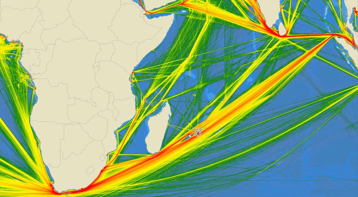
Part of the reason is simple geography. Mauritius and the nearby island of Reunion lie on the shortest straight-line route between the Strait of Malacca, which links the ports of Asia to the Indian Ocean, and the southern tip of Africa. That also makes it the route of choice for shipping between the huge markets and manufacturing centers of China, Japan, South Korea and the rest of Asia in the east, and the resource-rich regions of West Africa and Latin America, or the markets of Europe and North America, in the west.
“Mauritius is just on the ‘highway’ of international shipping,” said Peter Sand, chief shipping analyst at BIMCO, one of the world’s largest industry groups for shipowners.
A heat map showing showing a year of AIS ship tracking data in the Indian Ocean. Image courtesy Made Smart Group
In short, if a freighter is sailing between the eastern and western hemispheres, there’s a good chance that it will get somewhere close to the islands. The main alternative route is to navigate Egypt’s Suez Canal.
In the past 24 hours, more than 800 ships — from giant commodity carriers down to tiny freighters — sent position signals from the shipping lane that connects the southern tip of Madagascar to the northern tip of the Indonesian Island of Sumatra, vessel-tracking data observed by Bloomberg show. That compares with about 100 ships on a more southerly alternative route.
“Mauritius is bang on that route for all the ships coming out of Asia and heading into the Atlantic Basin going around the Cape of Good Hope,” said Richard Matthews, head of research at E.A. Gibson Shipbrokers Ltd. “They are just trying to find the shortest route.”
Just as in the 16th century, shipping routes today often tend to stick close to land. Satellite navigation systems may make it easier to pinpoint a ship in distress, but if that vessel is thousands of miles from the nearest shore, then getting specialized help to it in an emergency can take days.
Being closer to shore may allow ships to pick up internet signals, allowing crew members to contact family without needing to use expensive and limited satellite phones.
All that helps to explain why ships get within the vicinity of Mauritius. It doesn’t address why the carrier was in its precise location. That question, and many others, will now become a focal point as investigators figure out exactly what happened. Nor does it explain what steps the island nation may put in place to prevent such events in the future.
“Mauritius can put in place a safety zone which ships may not pass,” said BIMCO’s Sand. “Other nations have done so in other places.”
By Dr Ryan Lloyd, Head Of Research And Development at Geollect – On Sunday 25th July 2020, the Panama-flagged Japanese-owned MV Wakashio was involved in an incident on the south-east coast...
A contract to remove the stern of the Wakashio has been awarded in Mauritius as the salvage and clean-up continues more than three months after the ship grounded. The contract...
By Kamlesh Bhuckory (Bloomberg) — Mauritius rejected an application for bail made by Sunil Kumar Nandeshwar, the captain of the MV Wakashio that sunk off its southeastern coast in July....
October 20, 2020
Total Views: 455
Get The Industry’s Go-To News
Subscribe to gCaptain Daily and stay informed with the latest global maritime and offshore news
— just like 105,428 professionals
Secure Your Spot
on the gCaptain Crew
Stay informed with the latest maritime and offshore news, delivered daily straight to your inbox
— trusted by our 105,428 members
Your Gateway to the Maritime World!
Essential news coupled with the finest maritime content sourced from across the globe.

 Join The Club