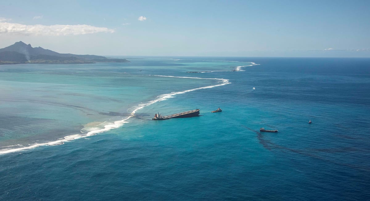
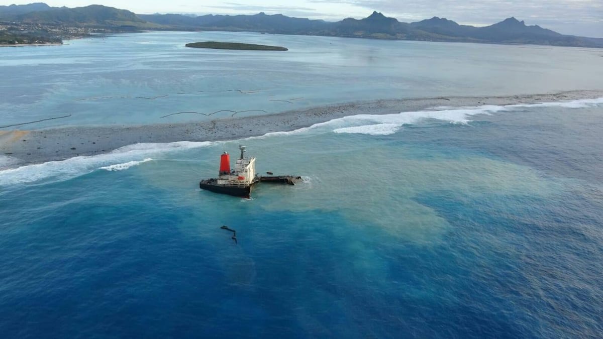
A general view shows the bulk carrier ship MV Wakashio, that ran aground on a reef, at Riviere des Creoles, Mauritius, in this handout image obtained by Reuters on August 10, 2020. French Army command/Handout via REUTERS
By Dr Ryan Lloyd, Head Of Research And Development at Geollect – On Sunday 25th July 2020, the Panama-flagged Japanese-owned MV Wakashio was involved in an incident on the south-east coast of Mauritius that resulted in over 1000 tonnes of bunker fuel spilling onto protected coral reefs & marine ecosystems. A formal investigation is ongoing, but several theories have been put forward to explain the cause. These range from poor weather conditions, alcohol abuse by the crew, and route planning and navigation issues.
This article will show that an incident such as this is complex and involve many different factors. Data exists to enable a human analyst to conduct research and develop understanding.
Weather
Before analyzing location insights from AIS, poor weather can very quickly be ruled out. Comparing the vessel route to local weather conditions, wave height, tides, and currents show this was not a factor. Drunkenness will be something under investigation by the relevant authorities and is not something we can comment on.
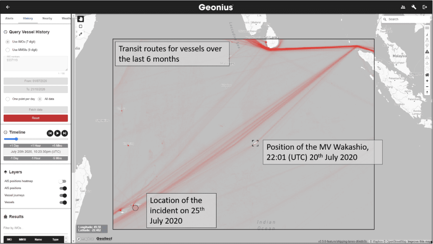
The route of the Wakashio through the Indian Ocean on 20 Jul. (Data accessed and analysed through Geollect’s geospatial intelligence and investigation platform, Geonius)
Assumptions based on AIS
It has been suggested that the cause for the incident lies four whole days before it occurred. Windward reported that the vessel took an unusual route through the Indian Ocean that was indicative of navigational incompetency. They also raise questions on the situational awareness of the managing organisation and relevant coastal authorities. It is suggested the vessel travelled for four days on a unique and unusual route with a direct collision course with a reef, and that this went unnoticed the entire time.
A more detailed investigation into typical shipping practices in the Indian Ocean, conducted by Geollect, suggests that in a typical month period (20th Sept – 20th Oct 2020) 56 cargo vessels and 38 tankers have taken the same route on a south/south-westerly course.
Adding context to AIS: Yet Another Unscheduled Turn
Taken on its own, AIS is limited. Adding some context and insights from what happens on a ship’s bridge starts to shape possible stories.
On its original course of 241° at 23:32 (UTC) 20th July, the vessel would have transited south of the island of Mauritius. This is typical for a vessel en route to Brazil.
However, 4 days later at 23:45 (UTC) on the 24th July the vessel made yet another slight unexplained deviation in course (at this point the vessel is 162 nautical miles from Mauritius, almost a 15 hour journey at 11 knots). The vessel changes from 242° to 247° for about 10 nautical miles, before correcting its course to be back in-line with its original route.
This manoeuvre has no obvious explanation.
An analysis of the vessel speed implies no engine issues. Occurring at around 04:00 local time.
Alternatively, the vessel may have been repositioning such that it would travel around the north of Mauritius and the crew then changed their minds to continue the original course. Either way, the realignment indicates a deliberate decision to head towards, or travel just south of, Mauritius.
There was an unusual deviation in route at around 0400 local time that is not explained. The vessel is still some distance from Mauritius and it does not directly lead to the accident. The course does indicate an intention to travel to Mauritius.
What was happening on the ship?
After this, at around 09:48 UTC on the 25th the vessel begins to alter its course, heading directly for the town of Mahébourg – a small town lacking the infrastructure to accommodate a 300m long vessel. Why would the vessel want to be heading in this direction?
It is possible that the Wakashio was requiring assistance. There may have been an equipment failure on board the vessel. This seems unlikely, given the vessel is capable of navigating towards the town, and that it would have been more sensible to navigate around the island Port Louis for repairs.
Alternatively, a medical emergency may explain why the vessel was heading towards the habitation. By this stage it had been 11 days since the vessel was anchored off Singapore. This is around the length of time required for crew to be presenting COVID related symptoms. It is not clear, however, whether there had been any human interaction in Singapore, so this also seems unlikely. Indeed, it is thought that two members of the crew had been on board for more than a year as a result of the pandemic.
If either of the above were true, one would have expected some communication between the vessel and the local authorities. We have no independent evidence either way, but it is alleged that the coast guard repeatedly tried to contact the vessel whilst on approach to Mauritius.
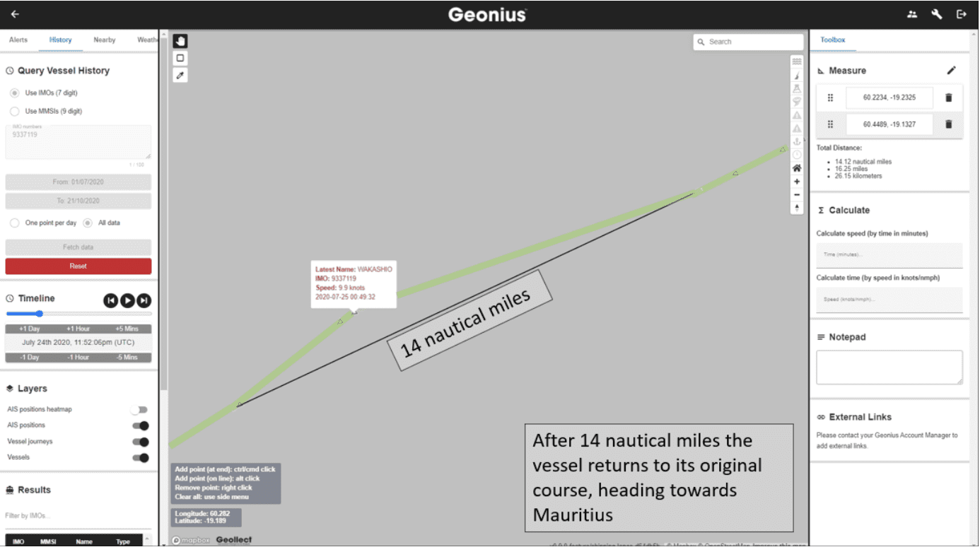
Late route change
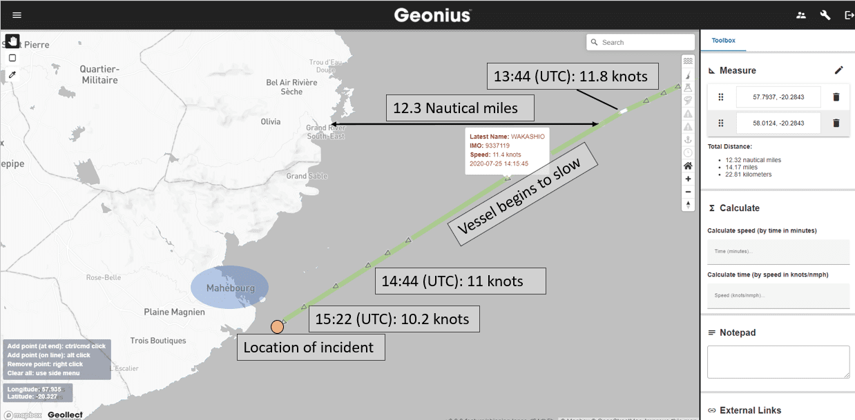
At 13:44 (UTC), 12 nautical miles away from shore the vessel changes course again, to 238°. This takes the Wakashio away from Mahébourg and onto a route that would take her around the south of the island. At this point, the vessel also begins to very gradually slow down. Perhaps, if the crew was intending to stop at Mauritius, it this the point they realize a visit is not possible? In July crew changes were not permitted, and bunker fuels, ships spares, provisions, lube oil, could only be delivered during cargo operations at berth in Port Louis, which was only operating during two shifts: 07:00-15:00 & 15:00-23:00, or at anchorage.
Geollect’s Geonius platform shows the change of course made on July 25 at 13:44 UTC taking the Wakashio away from Mahébourg
Phone signal
An alternative explanation is that they were never intending to visit. There is a theory that the vessel chose to travel close to the island to receive mobile phone signal. The vessel operator, Mitsui OSK Lines, have since confirmed their owned fleet have free and unlimited internet access. But it is unknown if this includes chartered vessels or whether data connectivity would be strong enough to enable Wi-Fi calling, or how good the signal would have been on this particular vessel.
This deviation was two hours before the incident occurred, and around 12 nautical miles from the coast.
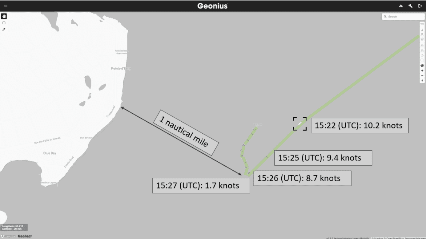
Geollect Geonius platform shows the gradual, and then rapid, slowing down of the Wakashio at the time of the incident. The rapid change in speed is indicative of a collision and grounding.
Why did the Wakashio slow down?
The waters the vessel was now heading into are only 1 nautical mile from the coast of Mauritius. There are coral reefs, shipwrecks, and tidal streams all marked on the standard UKHO nautical chart in the area, which would have been available to the crew through their onboard ECDIS system. At 15:22 (UTC, 19:22 local time) the vessel is traveling at 10.2 knots.
By now it is dark (sunset was at 17:50), but the crew should have been able to navigate using their charts. 650 meters and 3 minutes later the vessel is traveling at 9.4 knots. Another 310 meters on and just over a minute later the vessel is traveling at 8.7 knots. This slowing down could be cautious navigation, or an awareness of what was further along their path. 30 meters and 1 minute later the next AIS update indicates the vessel is traveling at 1.7 knots. A 7 knot decrease in speed over 30 meters is dramatic, and suggests the vessel collides with something here.
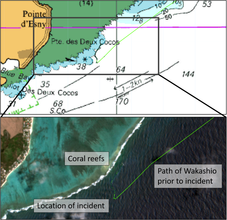
UKHO nautical chart (top) and Sentinel 2 satellite imagery (provided by the European Space Agency. bottom), alongside route of the Wakashio (green line). Hazards to navigation are highlighted.
No known obstacles
Charted water depth is recorded as between 38 and 50 m (much greater than the vessel 8.7 m draught), and a nearby shipwreck is labelled as too deep to impede navigation.
Higher resolution imagery on days with a calm sea surface, however, does show a protrusion of rock from where the Wakashio ran aground, likely between 3 and 9 meters deep. This is what the vessel collided with.
An inspection of the vessel in Australia on the 14th February 2020 highlighted a Safety of Navigation deficiency in the vessel’s nautical publications (Indian Ocean MoU, 2020). The exact nature of this deficiency is unclear. Questions will be asked as to which navigational charts the crew were using. Could the crew have foreseen the incident using the information available to them?
Human Factors
We do not currently know what was happening on the ship prior to, and at the time of the collision. It is unclear why the vessel was so close to shore. The crew on board had been at sea a long time, were likely missing their loved ones, and it is reported that the vessel was understaffed. Perhaps the additional workload may have led to fatigue, we will not know for sure until an onboard investigation has been completed.
Whilst we wait for the results, this article demonstrates why a detailed investigation, utilising human expertise and multiple sources of information, is so important before speculative conclusions can be drawn. There are many factors involved in an incident such as this. Assessments from AIS data alone rarely paint the full picture.
Data on its own cannot be classed as intelligence and a technology provider is not the same as an intelligence expert. A data-enabled, human-centred approach that considers all the evidence is the only way to provide balanced insight.
About Geollect
Geollect empowers clients to make better, more timely decisions with advanced intelligence products, which bring together a vast range of data science and geospatial services. We make intelligent, customisable and intuitive dashboards locate, that summarise and present the information you need, as it happens. Combined with a team of former military and government intelligence operators, we are able to provide actionable insights from data.”
A contract to remove the stern of the Wakashio has been awarded in Mauritius as the salvage and clean-up continues more than three months after the ship grounded. The contract...
By Kamlesh Bhuckory (Bloomberg) — Mauritius rejected an application for bail made by Sunil Kumar Nandeshwar, the captain of the MV Wakashio that sunk off its southeastern coast in July....
TOKYO, Sept 18 (Reuters) – Japan said on Friday it will send a five-person team to Mauritius to investigate the grounding of a Japanese-owned ship off the country’s coast that...
September 18, 2020
Total Views: 77
Get The Industry’s Go-To News
Subscribe to gCaptain Daily and stay informed with the latest global maritime and offshore news
— just like 104,637 professionals
Secure Your Spot
on the gCaptain Crew
Stay informed with the latest maritime and offshore news, delivered daily straight to your inbox
— trusted by our 104,637 members
Your Gateway to the Maritime World!
Essential news coupled with the finest maritime content sourced from across the globe.

 Join The Club