A bulk carrier’s striking of an oil and gas platform in the Gulf of Mexico off the coast Louisiana last year can be chalked up to poor bridge resource management, the National Transportation Safety Board said Tuesday.
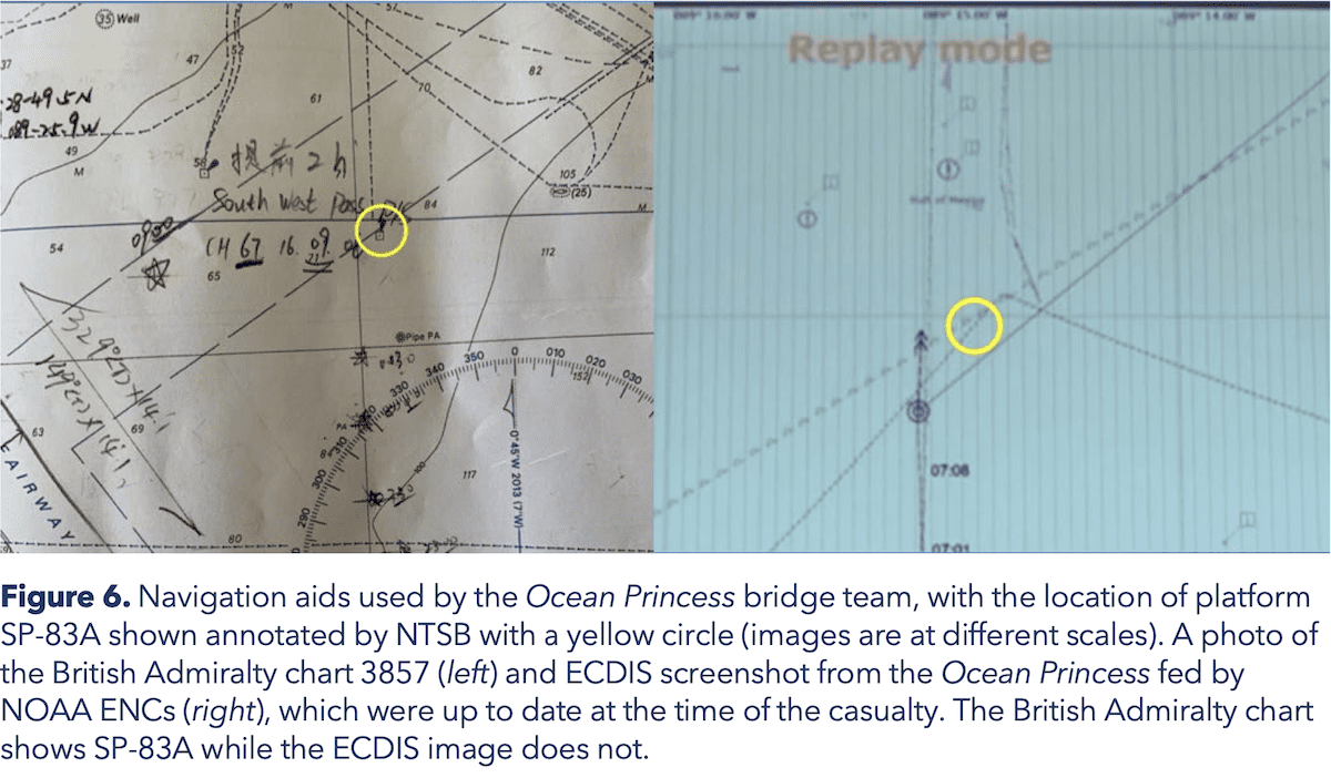
It seems the platform was shown on the British Admiralty paper chart used by the mate on watch, but was not included on the electronic navigation chart provided by NOAA that was displayed on the ship’s ECDIS.
The dry bulk carrier Ocean Princess struck the uncrewed and out-of-service oil and gas production platform SP-83A back on January 7, 2021, while operating 24 miles south of Pilottown, Louisiana. The NTSB published its report on the incident on Tuesday.
No pollution or injuries were reported, however, damage to the vessel and platform totaled an estimated $1.5 million.
The NTSB found that the 24-person crew of the Ocean Princess was drifting overnight in the Gulf of Mexico before going to New Orleans to load a cargo of grain. The master planned to drift throughout the night with the engine on 15-minute standby, keeping clear of traffic and platforms.
To give the crewmembers some rest after spending the day cleaning cargo holds, the master scheduled himself to be on the bridge with the mate on watch. After engaging the engine to maneuver the vessel, the master stated he saw a dim yellow light and checked the radar.
The master and the second officer on watch investigated the light and believed it was coming from an oil platform 5-6 miles away. Roughly 10 minutes later, the Ocean Princess struck platform SP-83A.
The master and second officer told NTSB investigators they never saw SP-83A on the radar. After the contact, both noted that the platform was on the paper chart used on the bridge by the mate on the watch, but SP-83A did not appear on the electronic chart display and information system (ECDIS).
The NTSB found the platform SP-83A was not charted on the official U.S. National Oceanic and Atmospheric Administration (NOAA) electronic or paper navigation charts that provided the chart data to the ECDIS aboard the Ocean Princess. The platform, however, did appear on the British Admiralty paper chart that the mate on watch was using at the time of the accident.
The NTSB investigation revealed the platform had been shown on the NOAA charts starting in 1990, but for some unknown reason it was omitted starting in 2010 from two larger-scale U.S. paper charts. It then remained off the two paper charts and electronic navigation charts (ENCs) for over 11 years—until after the accident.
The NTSB determined the probable cause of the contact of the Ocean Princess with platform SP-83A was poor bridge resource management, which resulted in the bridge team not identifying the platform and recognizing the risk it posed to their safe navigation even though they saw its lights about 10 minutes before the casualty. Contributing was platform SP-83A not being shown on the vessel’s electronic chart display and information system due to a charting error.
Following the incident, NOAA updated and corrected the electronic and paper charts that had been erroneously missing platform SP-83A.
“The effective use of all available resources by a bridge team, including paper charts, electronic charts, and radars, increases collective situational awareness and contributes to a safe navigation watch,” the report said. “When identifying hazards, bridge teams should avoid overreliance on a single data source by cross-checking information with available bridge resources and communicating identified risks with fellow watchstanders. Technology, such as an ECDIS, can result in operator overreliance and overconfidence that degrades sound navigation practices and negatively affects situational awareness.”
Read the report: Marine Investigation Report 22/18
Updated: October 17, 2023 (Originally published August 23, 2022)
Editorial Standards · Corrections · About gCaptain

 Join The Club