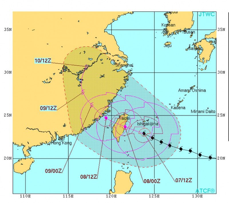
Taiwan is bracing for a direct hit by powerful Typhoon Soudelor, which earlier this week earned the title of earth’s strongest storm of 2015.
Our friends over at Ocean Weather Services tell us that today at 15Z Typhoon Soudelor was centered about 183 nautical miles southeast of Taipei, Taiwan and was moving WNW at 10 knots, with max winds of about 105 knots and significant wave heights up to 38 feet.
Soudelor is expected make landfall and cross central Taiwan later today before making a second landfall in eastern China on Saturday.
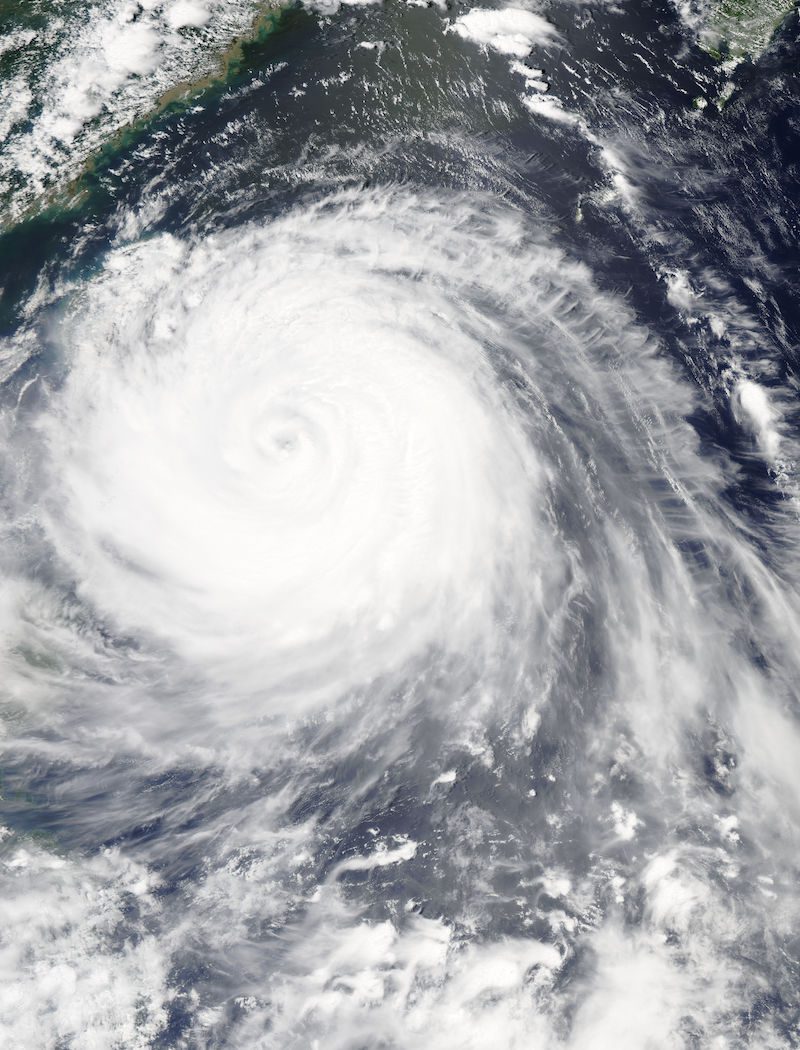
The MODIS instrument aboard NASA’s Aqua satellite flew over Typhoon Soudelor on Aug. 7, 2015, at 4:40 UTC (12:40 a.m. EDT) as it was approaching Taiwan. Credits: NASA Goddard’s MODIS Rapid Response Team
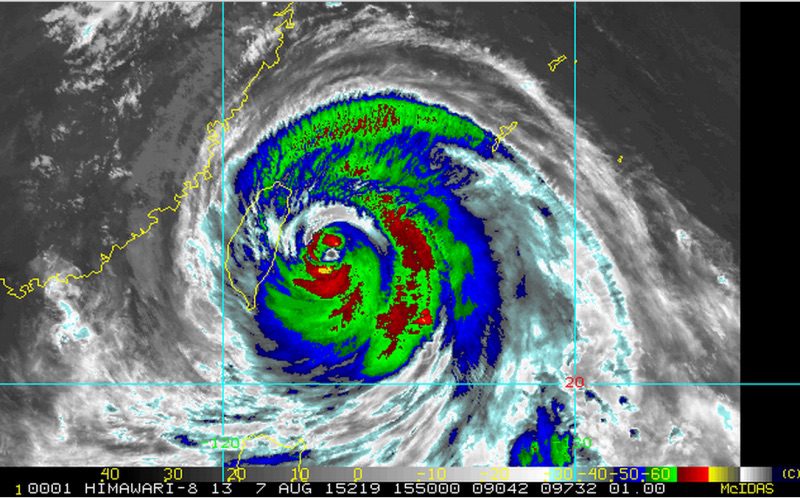
IR Satellite image by NOAA show’s location of Typhoon Soudelor as it approaches Taiwan, August 7, 2015.
Projected storm track
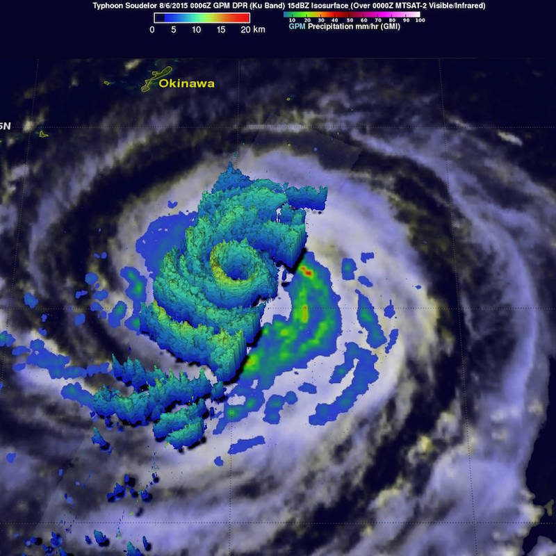
On August 6 at 0006 UTC, GPM saw Typhoon Soudelor’s heaviest rain a rate of close to 70 mm (2.4 inches) per hour in a strong thunderstorm band southwest of the center. Credits: NASA/JAXA, Hal Pierce
On Aug. 4, 2015, at 4:10 UTC (12:10 a.m. EDT) the MODIS instrument aboard NASA’s Aqua satellite captured this visible-light image of Super typhoon Soudelor as it reached Category 5 status on the on the Saffir-Simpson Wind Scale Credits: NASA Goddard’s MODIS Rapid Response Team
SINGAPORE, April 24 (Reuters) – Demand for liquefied natural gas (LNG) to power ships will rise this year on attractive prices, while more dual-fuel vessels join the global fleet, industry executives said....
ROME (Reuters) – An Italian judge on Friday cleared three migrant sea rescue charities that had been accused of abetting irregular immigration in complicity with human traffickers, throwing out a case opened...
(Bloomberg) — The closure of one of the East Coast’s busiest ports after the collapse of Baltimore’s Francis Scott Key Bridge has so far not led to broad price increases,...
April 19, 2024
Total Views: 2193
Why Join the gCaptain Club?
Access exclusive insights, engage in vibrant discussions, and gain perspectives from our CEO.
This website uses cookies to improve your experience while you navigate through the website. Out of these, the cookies that are categorized as necessary are stored on your browser as they are essential for the working of basic functionalities of the website. We also use third-party cookies that help us analyze and understand how you use this website. These cookies will be stored in your browser only with your consent. You also have the option to opt-out of these cookies. But opting out of some of these cookies may affect your browsing experience.
Necessary cookies are absolutely essential for the website to function properly. This category only includes cookies that ensures basic functionalities and security features of the website. These cookies do not store any personal information.
Any cookies that may not be particularly necessary for the website to function and is used specifically to collect user personal data via analytics, ads, other embedded contents are termed as non-necessary cookies. It is mandatory to procure user consent prior to running these cookies on your website.

 Join The Club