Join our crew and become one of the 106,849 members that receive our newsletter.
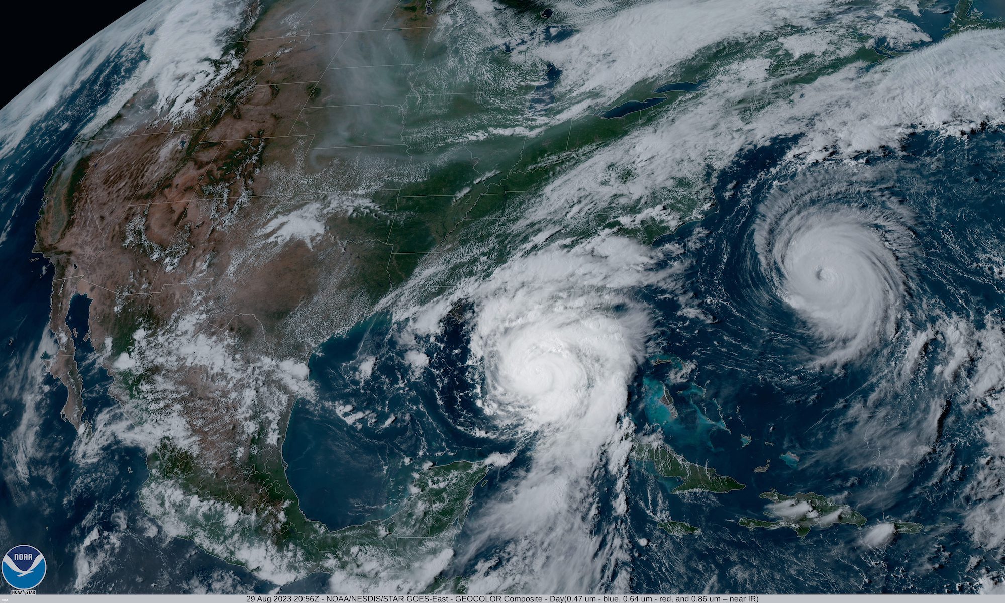
NOAA's GOES-16 satellite captured Hurricane Idalia approaching the western coast of Florida while Hurricane Franklin churned in the Atlantic Ocean at 5:01 p.m. EDT on August 29, 2023. (Image credit: NOAA Satellites)
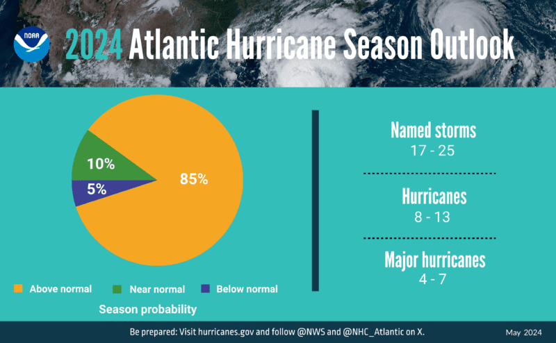
Confidence High for Above-Normal Atlantic Hurricane Season
The National Oceanic and Atmospheric Administration (NOAA) National Weather Service forecasters have predicted that the 2024 Atlantic hurricane season will be more active than normal due to a combination of warmer-than-average ocean temperatures and shift to La Nina.
The hurricane season, which runs from June 1 to November 30, has an 85% probability of above-normal activity—the highest confidence forecasters have had in any above-average seasonal outlook—with a 10% chance of being near-normal and only a 5% chance of falling below-normal.
NOAA forecasters are predicting a range of 17 to 25 total named storms, with winds reaching at least 39 mph. Out of these, between 8 to 13 are anticipated to escalate into hurricanes, exhibiting winds exceeding 74 mph. Furthermore, 4 to 7 could potentially become major hurricanes, categorized as 3, 4, or 5, with wind speeds over 111 mph. Forecasters have 70% confidence in these predictions.
The prediction also reportedly marks the highest number of hurricanes ever forecasted by NOAA in its annual May forecast, exceeding the 2010 forecast of 14-23 storms.
Credit: NOAA
Several factors are contributing to this expected increase in hurricane activity. These include near-record warm ocean temperatures in the Atlantic Ocean, the development of La Nina conditions in the Pacific, reduced Atlantic trade winds, and decreased wind shear. All of these conditions are known to foster the formation of tropical storms.
NOAA scientists expect a quick transition to La Nina conditions, which tend to lessen wind shear in the tropics and are conducive to Atlantic hurricane activity. This, coupled with abundant oceanic heat content in the tropical Atlantic Ocean and Caribbean Sea, creates more energy to fuel storm development.
This hurricane season may also see an above-normal west African monsoon, leading to African easterly waves that seed some of the strongest and longest-lived Atlantic storms. Light trade winds will further enable hurricanes to grow in strength without disruption from strong wind shear and will minimize ocean cooling. The human-caused climate change is a significant contributing factor, warming our ocean globally and in the Atlantic basin, leading to sea level rise, which increases the risk of storm surge.
The Panama Canal Authority has announced another increase in the number of daily transits through the waterway’s locks as rainfall returns to the region. The current number of daily transits...
The International Longshoremen’s Association (ILA) has suspended negotiations with the United States Maritime Alliance over a new labor contract for dockworkers at U.S. East Coast and Gulf Coast ports, fueling...
Scorpio Tankers Inc. (NYSE: STNG) is selling five of its older MR product tankers for a total of $179.1 million. The sales, expected to close in the third quarter of...
14 hours ago
Total Views: 979
Why Join the gCaptain Club?
Access exclusive insights, engage in vibrant discussions, and gain perspectives from our CEO.
This website uses cookies to improve your experience while you navigate through the website. Out of these, the cookies that are categorized as necessary are stored on your browser as they are essential for the working of basic functionalities of the website. We also use third-party cookies that help us analyze and understand how you use this website. These cookies will be stored in your browser only with your consent. You also have the option to opt-out of these cookies. But opting out of some of these cookies may affect your browsing experience.
Necessary cookies are absolutely essential for the website to function properly. This category only includes cookies that ensures basic functionalities and security features of the website. These cookies do not store any personal information.
Any cookies that may not be particularly necessary for the website to function and is used specifically to collect user personal data via analytics, ads, other embedded contents are termed as non-necessary cookies. It is mandatory to procure user consent prior to running these cookies on your website.

 Join The Club