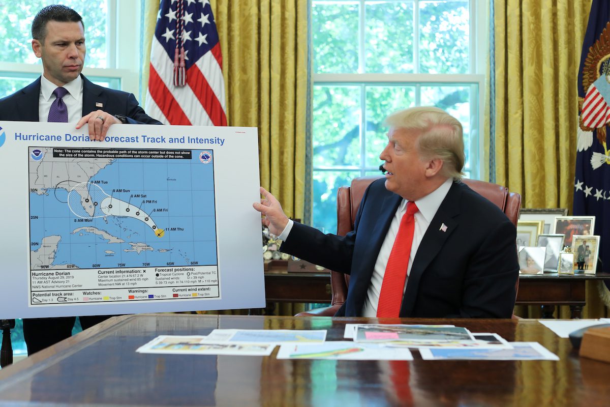
U.S. President Donald Trump holds up a hurricane track chart with Acting DHS Secretary Kevin McAleenan as he talks to reporters during a status report meeting on Hurricane Dorian in the Oval Office of the White House in Washington, U.S., September 4, 2019. REUTERS/Jonathan Ernst
President Donald Trump is drawing criticism for sharing a week-old National Weather Service map that had been altered to show the track of Hurricane Dorian extending further into the Gulf coast than had previously been predicted.
Trump displayed the map before reporters on Wednesday during briefing on Hurricane Dorian from the Oval Office of the White House.
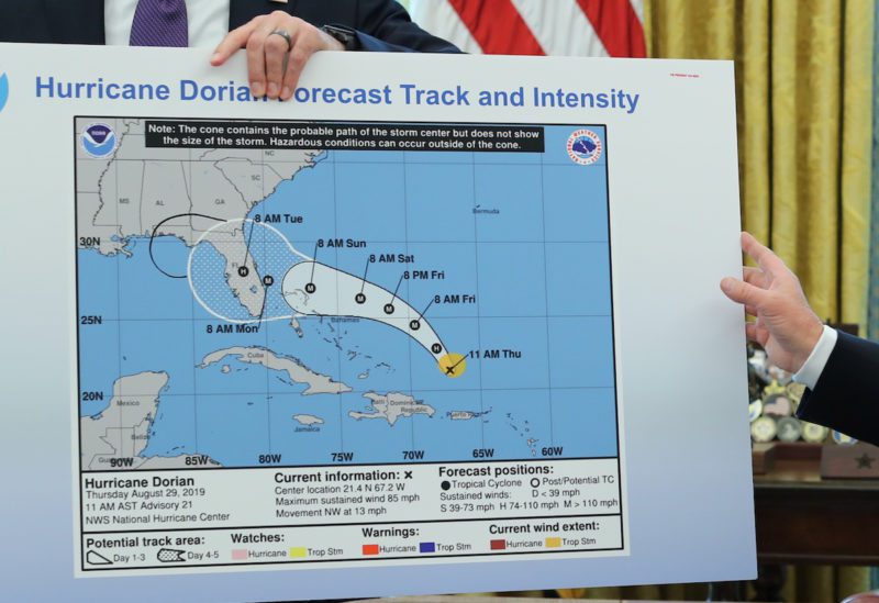
The map, which is dated Thursday, August 29, 2019, included a seemingly hand-drawn, black semi-circle extending the 5-day cone into southwestern Georgia and parts of Alabama. The map was handed to him by Acting Secretary of Homeland Security Kevin McAleenan as President Trump explained “the original chart” that showed Dorian possibly heading into the Gulf of Mexico.
REUTERS/Jonathan Ernst
People on social media are speculating that the map was altered to prove President Trump’s false claim on Twitter that the storm threatened Alabama.
“In addition to Florida – South Carolina, North Carolina, Georgia, and Alabama, will most likely be hit (much) harder than anticipated. Looking like one of the largest hurricanes ever. Already category 5. BE CAREFUL! GOD BLESS EVERYONE!” – @realDonaldTrump (Sept 1, 2019)
A video of the odd exchange was shared by the White House’s official Twitter account:
Some on Twitter have pointed out that altering a National Weather Service forecast map is in violation of federal law, specifically 18 U.S. Code §?20, which states:
Whoever knowingly issues or publishes any counterfeit weather forecast or warning of weather conditions falsely representing such forecast or warning to have been issued or published by the Weather Bureau, United States Signal Service, or other branch of the Government service, shall be fined under this title or imprisoned not more than ninety days, or both.
Of course, a real forecast map issued by the National Weather Service around the time of the Oval Office briefing showed Hurricane Dorian off the northeastern Florida coast, moving towards Georgia and South Carolina.
The Hurricane Warning has been extended northward to the North Carolina/Virginia border, including Albemarle and Pamlico Sounds. The warning now runs from North of Savannah River to the NC/VA border and the above sounds. More on #Dorian is at https://t.co/tW4KeFW0gBpic.twitter.com/BlG6Q4BMFk
Many people have attempted to defend President Trump’s statements by claiming the NWS forecasts had changed over time, with earlier maps showing Dorian possibly headed into the Gulf of Mexico. The video below however debunks those claims, showing that the 5-day cone never entered Alabama and the NWS forecasts remained surprisingly accurate throughout the duration of the storm:
Every ?@NHC_Atlantic? forecast for #Dorian from first advisory to the most recent. Remarkable forecast by the world’s best tropical forecasters. Thank you for your dedication, honesty, expertise, and help! pic.twitter.com/kuuEm9vyJT
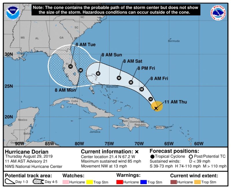
For those of you still skeptical curious, here is the NWS National Hurricane Center’s Advisory 21 from August 29, 2019, the same one President Trump presented today (September 4) in the Oval Office:
Update: President Trump has responded on Twitter, sharing a “spaghetti” map from the South Florida Water Management Services District:
This was the originally projected path of the Hurricane in its early stages. As you can see, almost all models predicted it to go through Florida also hitting Georgia and Alabama. I accept the Fake News apologies! pic.twitter.com/0uCT0Qvyo6
However, the above map contains the disclaimer “NHC Advisories and Count Emergency Management statement supersede this product. This graphic should complement, not replace, NHC discussions. If anything on this graphic causes confusion, ignore the entire product,” which I think would apply in this case.
Again, below is President Trump’s version of the September briefing map (from Aug 29):
By Will Wade and Jess Shankleman (Bloomberg) — The U.S. has officially become the first nation to quit the Paris climate agreement, even as the outcome of the country’s presidential...
Sept 5 (Reuters) – A boat parade in support of U.S. President Donald Trump crowded Lake Travis in Texas on Saturday, generating waves and choppy waters that led at least...
By Jordan Fabian and Jenny Leonard (Bloomberg) –President Donald Trump threatened to impose tariffs on cars made in the European Union and on unspecified Chinese products unless the trading partners...
June 5, 2020
Total Views: 210
Get The Industry’s Go-To News
Subscribe to gCaptain Daily and stay informed with the latest global maritime and offshore news
— just like 104,486 professionals
Secure Your Spot
on the gCaptain Crew
Stay informed with the latest maritime and offshore news, delivered daily straight to your inbox
— trusted by our 104,486 members
Your Gateway to the Maritime World!
Essential news coupled with the finest maritime content sourced from across the globe.

 Join The Club