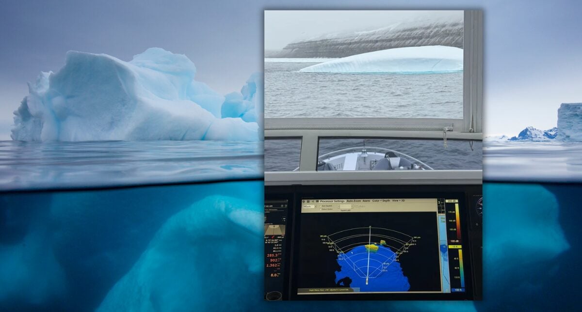
The Arctic and Antarctic are increasingly becoming areas of convergence for maritime industries and government operations. Commercial shipping, offshore energy, expedition cruising, recreational yachting, scientific research, coast guard, and naval operations are all placing greater attention on these remote regions. For some, polar waters offer access to untapped natural resources and emerging shipping routes. For others, they provide opportunities for exploration, scientific discovery, and strategic operations in areas of growing geopolitical importance.
But operating in these environments presents a unique set of challenges. Extreme weather, floating ice, limited infrastructure, and vast distances from support resources compound the risks associated with maritime operations. Even routine navigational decisions can carry significantly greater consequences when rescue capabilities and emergency response resources are hours or days away. Furthermore, the environmental sensitivity of these regions means that groundings, collisions, and pollution incidents can have lasting consequences.
Understanding the environment above and below the waterline is critical to navigating these unforgiving waters. While radar, electronic charts, and other conventional navigation systems remain essential tools, they cannot always provide a complete picture of the hazards that lie ahead. In regions where chart data is sparse, satellite positioning can be degraded, and submerged hazards remain hidden from view, real-time underwater perception becomes an important part of safe vessel operations.
For 25 years, FarSounder has developed technology to help mariners better understand their surroundings and navigate with greater confidence. Today, FarSounder’s Argos 3D Forward Looking Sonars are deployed on vessels operating in polar environments, including expedition cruise ships, polar research vessels, and naval platforms, some of which are icebreakers. These vessels leverage real-time awareness of the underwater environment to safely navigate some of the most remote and challenging waters on Earth.
Navigating in Polar Regions
Polar operations introduce unique hazards that complicate even the most routine maritime activities. Floating ice presents a significant navigational risk, as the visible portion above the surface may not accurately represent the size and shape of submerged ice keels below the waterline. Icebergs and other large ice masses can extend considerable distances beneath the surface, creating hazards that are difficult to assess through visual observation alone. The seafloor presents another challenge. In these regions, accurate chart data is sparse or nonexistent, leaving shallow bottoms, rocky pinnacles, and other underwater obstructions hidden. Even where charts are available, the underlying survey data may be outdated or lack the resolution necessary for safe navigation in unfamiliar waters.
Navigation is further complicated by harsh weather conditions. High-latitude environments and magnetic anomalies can degrade the reliability of GPS and other positioning systems. Satellite communications may be intermittent, limiting a vessel’s ability to access external information or maintain consistent connectivity with shore-based resources. Extreme weather, fog, precipitation, and frigid temperatures can reduce the effectiveness of radar and optical sensors, making it more difficult to identify hazards above the surface.
These challenges are amplified by the isolation of polar operations. Search and rescue efforts in these regions face extreme logistical difficulties, complicating both the detection of vessels in distress and the ability to safely reach them. An incident that might be relatively manageable in more populated waters can quickly become a serious emergency when support is far beyond reach.
Groundings and collisions also present an increased risk to the surrounding environment. Oil spills and other pollution incidents are particularly difficult to contain in polar waters due to harsh operating conditions, limited infrastructure, and restricted response capabilities. These regions are also home to numerous native and migratory whale species, many of which are endangered. Vessel strikes remain a significant human-caused threat to whales, further elevating the environmental consequences of maritime operations.
Underwater Perception Solution
For 25 years, FarSounder has developed Argos 3D Forward Looking Sonar systems designed to provide real-time situational awareness of what lies beneath the surface ahead of the vessel. Argos sonars provide a real-time 3D image of the water column and seafloor out to distances of up to 1000 meters, enabling operators to make informed decisions before hazards become immediate threats. The Argos system’s low-frequency operation ensures that acoustic output remains benign to marine life, while still enabling the detection of large marine mammals such as whales.
Ice, in particular, is an ideal sonar target. Its dense, reflective structure produces strong acoustic returns, allowing Argos systems to detect submerged ice masses that lie beneath the surface. At the same time, it maps the seafloor ahead at ranges of at least eight times the water depth below the sensor. In poorly charted or uncharted waters, this capability reveals shallows and obstructions like rocky pinnacles extending from the seafloor and moving hazards in the water column, including whales.
In environments where GPS is degraded, communications are intermittent, and charts are unreliable, Argos systems continue to deliver consistent, real-time data. With a rapid update rate and the ability to scan from the seafloor to the surface in a single ping, operators gain a continuous understanding of the space ahead
Polar Charts: Unreliable, Outdated, or Non-Existent
Beyond underwater perception ahead, Argos sonars also create a map of the collected seafloor data. These recorded depth measurements are recalled when returning to a previous location, allowing vessels to identify and follow safe routes where chart data is unreliable. The sonar’s software enables this data to be anonymously shared across the FarSounder fleet. In return, vessels will gain access to an aggregate map of all other customer contributions. This program also supports global ocean mapping initiatives like Seabed 2030.
These crowdsourcing efforts have been able to provide tangible value for the broader maritime community operating in Arctic regions. FarSounder’s crowdsourced bathymetry (CSB) data is unique compared to most other CSB contributions in that it has high quality meta-data. This makes FarSounder customer CSB valuable in that it can be more reliably used for other applications. For example, because of the meta-data quality, CSB contributed by one of our customers transiting the Northwest Passage was included in an official chart produced by the Canadian Hydrographic Service.
While poorly charted waters are an obvious concern for polar operators, the reliability of nautical charts is not exclusively an issue in remote regions. Even areas generally considered to be among the best surveyed and charted in the world can contain significant discrepancies between charted depths and actual seafloor conditions. Work conducted by Anthony Klemm, Physical Scientist at NOAA’s Coast Survey Development Lab, comparing crowdsourced bathymetry and satellite-derived bathymetry (SDB) with NOAA’s BlueTopo database and official nautical charts, has identified numerous locations where charted depths differ dramatically from measured conditions.
One example involved a FarSounder customer transiting off the coast of Massachusetts near Nantucket. During the voyage, the vessel passed over a shoal charted to be approximately 10–12 meters deep. However, measurements collected by the vessel’s Argos sonar indicated that the actual depth was closer to 5 meters. The measured data was shared through the IHO Data Centre for Digital Bathymetry (DCDB). Anthony analyzed the contribution and found that the shoal identified in the crowdsourced data correlated with a seafloor trend visible in satellite-derived bathymetry for the same location.
Fortunately, the transiting vessel was a relatively shallow-draft pleasure craft. However, had a larger commercial vessel passed over the same shoal, particularly at low tide, the discrepancy could have resulted in a grounding. This example is not an isolated occurrence. Using crowdsourced bathymetry data, Anthony has been developing automated tools to identify additional locations where charted depths may not accurately reflect actual conditions, including waters generally considered to be among the best charted areas in the world.
These findings highlight an important consideration for maritime operators: even official nautical charts cannot always be relied upon to provide a complete representation of the underwater environment. In remote polar regions, where hydrographic survey coverage is significantly limited, the potential for encountering unknown hazards is even greater.
Improving Awareness in the World’s Most Remote Waters
For FarSounder, these challenges are not simply theoretical. Argos 3D Forward Looking Sonars have been installed on ice-classed hulls, icebreakers, and customer vessels that regularly operate in polar regions for more than two decades. Expedition cruise ships and explorer yachts leverage this technology to reach remote destinations, providing truly unique experiences for guests onboard. Icebreakers, naval ships, and research vessels are able to identify submerged ice and underwater obstacles, helping to reduce risk and extend operations into locations critical to their missions.
Customers have experienced firsthand the difference that real-time underwater awareness can make in these environments. Ice Pilot Captain Clive Shute described his first experience using Argos while navigating ice-rich waters off Greenland:
“I was lucky to have the opportunity to use FarSounder’s Argos Forward Looking Sonar for the first time recently. We were taking the ship in the ice-rich waters off Greenland. Having the Argos system installed proved to be a game-changer in safety.”
Other customers have shared examples of Argos identifying hazards that conventional navigation tools failed to reveal. Captain Walter Wetmore described an instance where the system identified a shoreline that was incorrectly represented on the chart, helping the vessel avoid a potential grounding and avoid floating ice while navigating fjords:
“The system clearly showed a shoreline, which was incorrectly shown on the chart, and helped avoid a grounding. It also showed growlers and bergy bits when traveling up the fjords. I will not travel to areas of ice again without the FarSounder systems.”
For some operators, the technology has become an essential part of their ability to undertake these voyages in the first place. Reflecting on the capabilities Argos sonars provides while exploring remote polar waters, the owner of MY Warbird offered a simple but powerful statement:
“We would not have gone that far north without the FarSounder.”
As more sectors of the maritime industry shift their focus toward polar regions, the need for reliable, real-time underwater perception will continue to grow. FarSounder’s technology provides an innovative solution backed by 25 years of experience supporting those operating in some of the world’s most challenging maritime environments.
FarSounder has been awarded the prestigious Excellence in Technology Award by the International Superyacht Society during their Design & Leadership Awards Gala. Held on October 30th at the Broward Center for the...
FarSounder has released their CSB Data Explorer. This web-based platform enables contributors of CSB (crowdsourced bathymetry) data to easily see where they’ve made contributions and gauge their support of the CSB community....
FarSounder Argos 3D Forward Looking Navigation Sonars have been included in the navigation control system for two Unmanned Surface Vessels (USV) built in Türkiye. The vessels have comprehensive automation technologies...
January 19, 2023
Total Views: 543
Get The Industry’s Go-To News
Subscribe to gCaptain Daily and stay informed with the latest global maritime and offshore news
— just like 106,073 professionals
Secure Your Spot
on the gCaptain Crew
Stay informed with the latest maritime and offshore news, delivered daily straight to your inbox
— trusted by our 106,073 members
Your Gateway to the Maritime World!
Essential news coupled with the finest maritime content sourced from across the globe.
 Join The Club