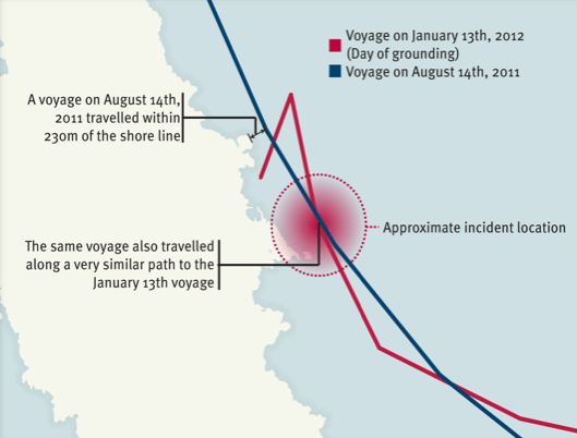
We’ve already seen video of the Costa Concordia showing off near Giglio, now Lloyd’s List has put together this infographic showing a similar–and possibly approved– course the Costa Concordia took during a voyage on August 14. This time, the cruise ship passed to within 230m from the shores of Giglio.
Not only is this info painting a grim picture for the captain and officers of the Costa Concordia, but for Costa Cruises and its parent company, Carnival.
“The previously approved route took the vessel far closer to shore than the 500 metres claimed by Costa,” explains Richard Meade, Editor of Lloyd’s List in a press statement. “This is not a black and white case. Our data suggests that both routes took the vessel within 200 metres of the impact point and that the authorised route was actually closer to shore.”
Could this “showboating” have been common practice for the Costa Concordia? I guess we’ll have to wait to see what unfolds in the investigation.
Editorial Standards · Corrections · About gCaptain

 Join The Club