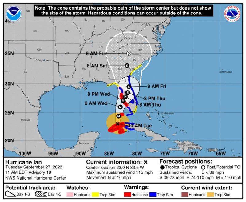
The latest forecast from the NWS National Hurricane Center on Hurricane Ian paints an ominious picture for state of Florida.
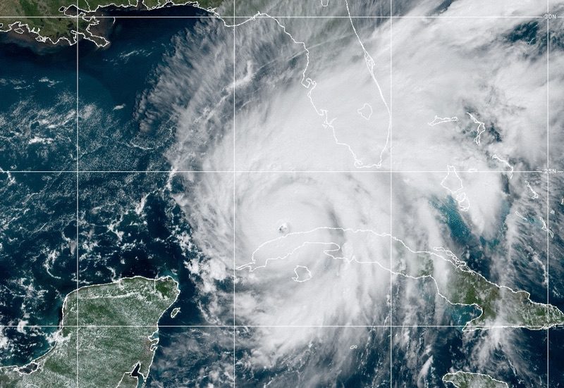
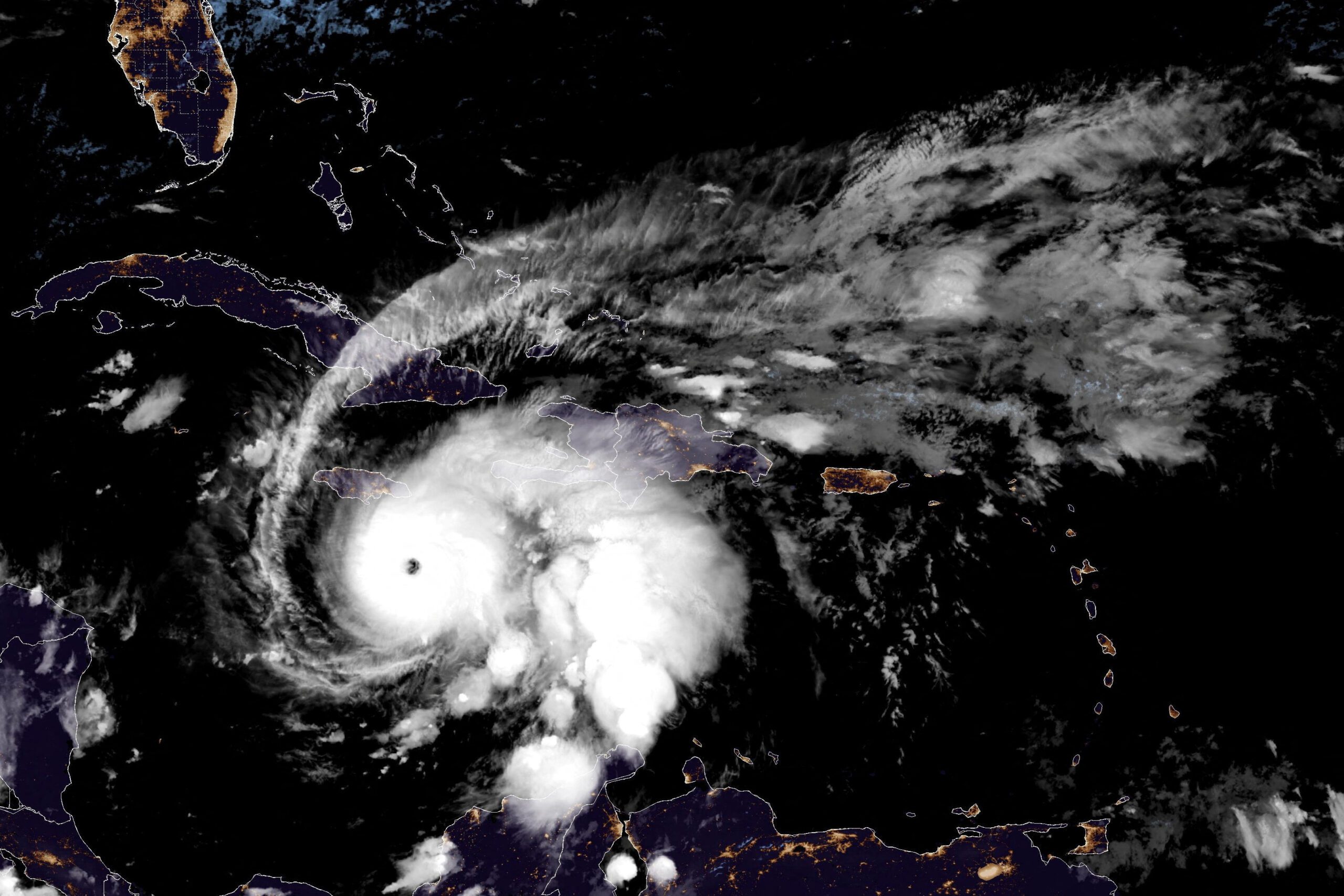
Hurricane Ian passed over Cuba hurricane Monday night before emerging in the southeastern Gulf of Mexico as a powerful category 3 hurricane with sustained winds of 115 mph and higher gusts.
Ian is forecast to approach the west coast of Florida as an extremely dangerous major hurricane Wednesday into Wednesday night, bringing with it hurricane-force winds, heavy rains, considerable floding, and life-threatening storm surge to the central Gulf Coast of Florida from Fort Myers to the Tampa Bay area.
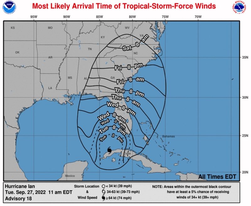
As of 11 a.m. Eastern Time, Hurricane Ian was located about 305 miles south-southwest of Sarasota, Florida, moving toward the north at 10 mph. A turn toward the north-northeast forecast tonight and Wednesday along with a eyebrow-raising reduction in forward speed.
By 3 p.m. ET, the minimum pressure had decreased to 952 millibars.
The National Weather Service published a great thread Twitter thread highlighting some of the dangers associated with the storm.
Follow: @NWS and @NHC_Atlanticon Twitter for the latest on Hurricane Ian.
The well-defined eye of Ian emerged off the coast of western Cuba about an hour ago, with a maximum sustained wind speed of 100kt/115mph — a category three hurricane.
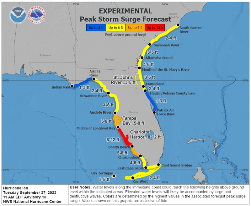
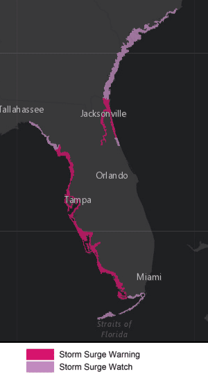
Life-threatening storm surge looks increasingly likely along much of the FL west coast where a storm surge warning is in effect, with the highest risk from Fort Myers to the Tampa Bay region. Listen to advice given by local officials and follow evacuation orders.
Hurricane-force winds are expected in the hurricane warning area in southwest and west-central Florida beginning Wednesday morning with tropical storm conditions expected by this evening. Residents should rush all preparations to completion today.
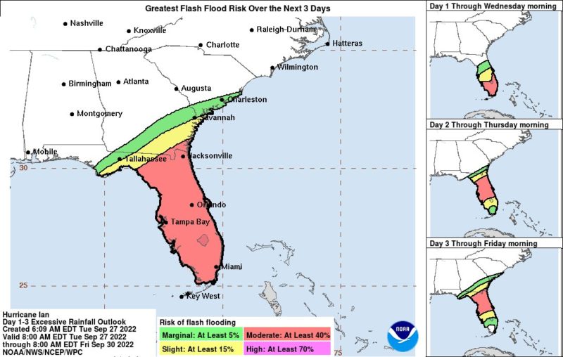
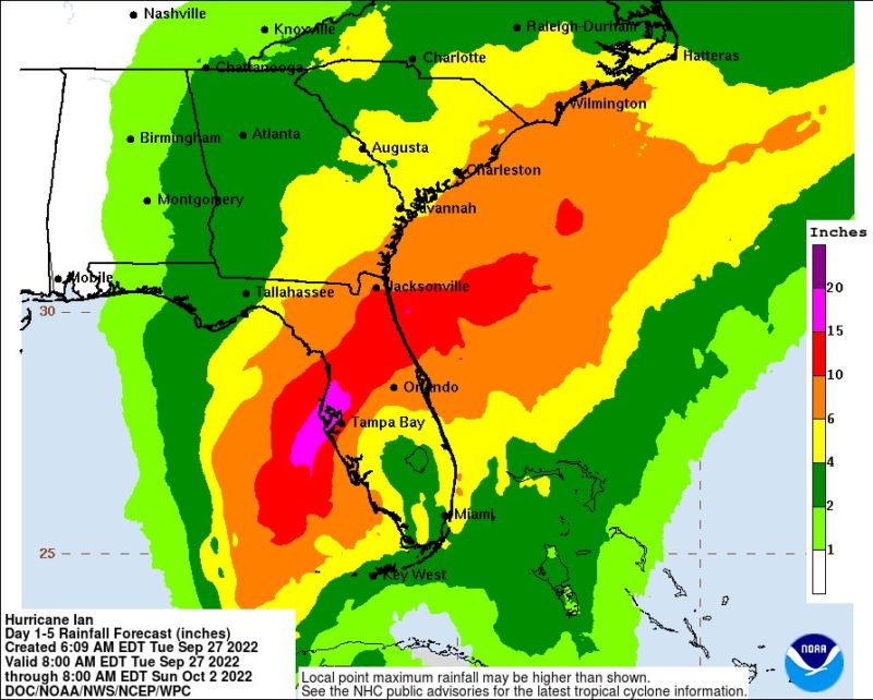
Heavy rainfall will increase across the Florida Keys and south Florida today, spreading into central and northern Florida tonight and Wednesday, into the Southeast U.S. by Thursday and Friday, likely causing flash, urban, and small stream flooding.
Considerable flooding is expected across central Florida into southern Georgia and coastal South Carolina, with widespread, prolonged moderate to major river flooding expected across central Florida.
As you can see below, the eye of Hurricane Ian is now well-defined:
Just checked out the Key West radar. Holy crap is that a specimen—all the more impressive because it’s recovering from land interaction. #Hurricane#IANpic.twitter.com/CccnHhRXfs
The U.S. Coast Guard is also preparing for the storm, conducting a pre-storm overflight of the Tampa Bay area and staging assets in Freeport, Bahamas for storm avoidance and relief efforts once the storm has passed.
The U.S. Coast Guard Captain of the Port (COTP) has now ordered Port Condition ZULU for the ports of Tampa, St. Petersburg, and Manatee, and Fort Myers due to the possibility of gale force winds (34-47 mph) entering the Tampa Bay area within 12 hours. ZULU means no vessel movements and port waterfront operations unless previously authorized by the COTP.
Here’s another look at Ian’s eye developing this morning:
As #HurricaneIan churns near Cuba, #GOESEast can see its distinct eye as well as #lightning flashing around the storm.#Ian is a major Category 3 #hurricane that is continuing to strengthen in the southeastern Gulf of Mexico.
NASA has now moved its Artemis I rocket back into the Vehicle Assembly Building at the agency’s Kennedy Space Center to ride out the storm.
Arrived! The #Artemis I stack has entered the Vehicle Assembly Building where technicians will prepare Orion and @NASA_SLS to ride out Hurricane Ian. pic.twitter.com/HsYa2RwWxE
A powerful and rapidly intensifying storm system over the North Atlantic is generating hurricane-force winds and enormous seas, prompting urgent warnings from U.S. forecasters for mariners operating in the region....
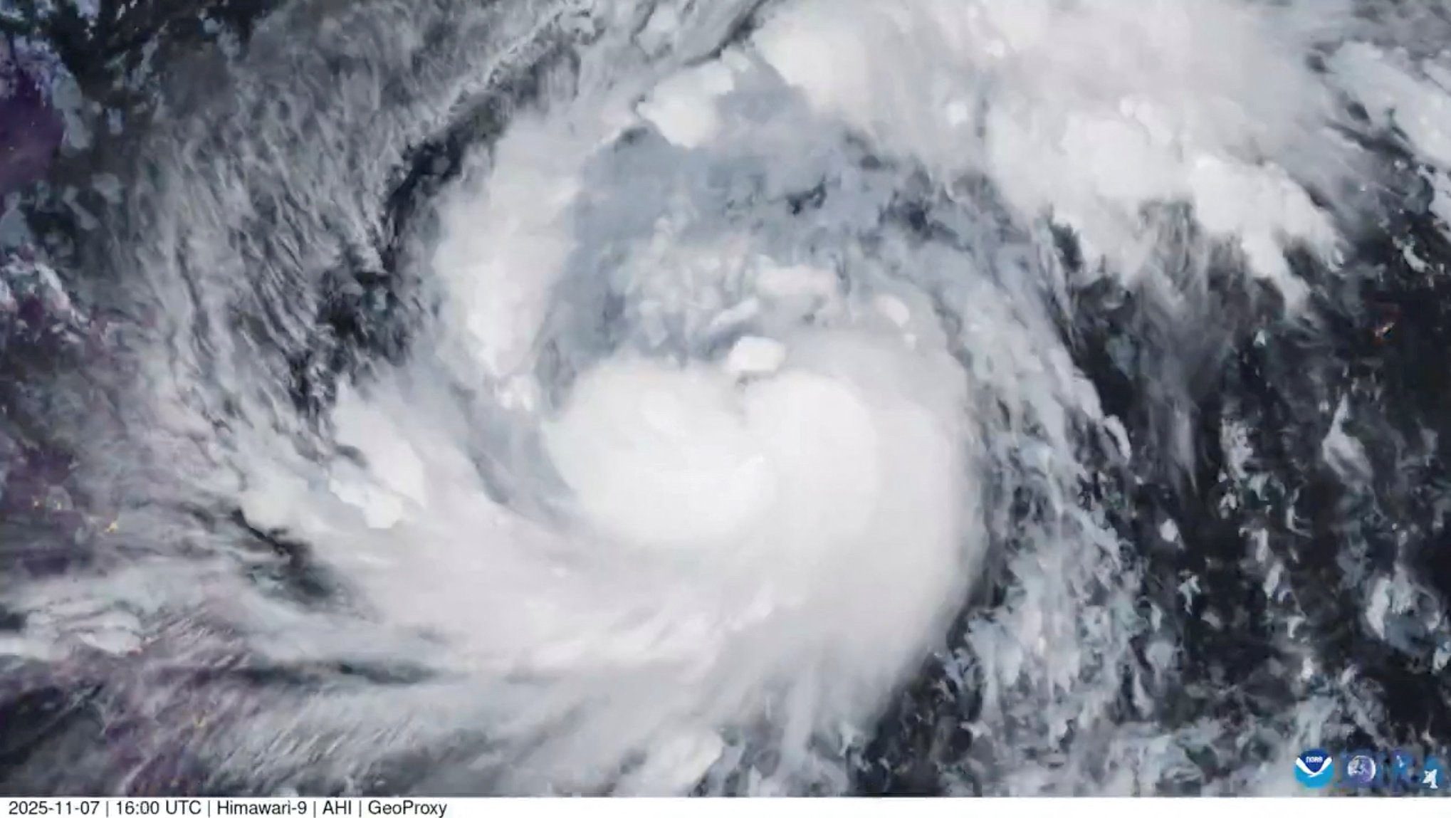
By Neil Jerome Morales Nov 9, 2025 (Bloomberg) –Super typhoon Fung-Wong hit the Philippines’ northeast late on Sunday with 185 kilometers per hour (115 miles per hour) winds and gusts of...
By Brian K. Sullivan and Scott Squires Oct 26, 2025 (Bloomberg) –Storm Melissa exploded in strength overnight, barreling toward an expected landfall Tuesday on Jamaica as a major hurricane and threatening...
October 26, 2025
Total Views: 1734
Get The Industry’s Go-To News
Subscribe to gCaptain Daily and stay informed with the latest global maritime and offshore news
— just like 105,149 professionals
Secure Your Spot
on the gCaptain Crew
Stay informed with the latest maritime and offshore news, delivered daily straight to your inbox
— trusted by our 105,149 members
Your Gateway to the Maritime World!
Essential news coupled with the finest maritime content sourced from across the globe.

 Join The Club