(Bloomberg) —
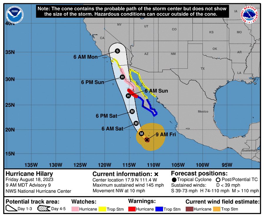
Hurricane Hilary’s winds exploded in strength overnight to reach Category 4 intensity as the rare eastern Pacific storm churned north on a path toward California.
Warm water fueled Hilary’s strength, which burst from a tropical storm Thursday into a major hurricane with winds of 145 miles per hour (233 kilometers per hour) as of 6 a.m. local time, according to a US National Hurricane Center advisory. Hilary is forecast to come ashore in Mexico over the weekend before lashing California and the US Southwest with flooding rains through Monday.
Hurricane and tropical storm watches and warnings have been raised along much of Mexico’s Baja California coastline, as well as parts of its mainland shore. Flooding rains that could trigger landslides from late Friday to Sunday are likely across the peninsula.
The storm could get even stronger, potentially even reaching the maximum Category 5 strength on the Saffir-Simpson scale before easing when it starts moving over cooler water, said Adam Douty, a meteorologist with commercial forecaster AccuWeather Inc.
“By the time it gets close to land it should have lost a fair bit of intensity,” he said.
As Hilary makes landfall in Mexico’s Baja California, its winds should have weakened to about 75 mph, according to the hurricane center. It’ll likely be at tropical storm strength as the storm moves into California late Sunday and weaken further when Hilary moves inland.
Downpours
Still, Hilary is expected to bring widespread heavy rain to California and the US Southwest, raising risks of power outages, mudslides and flooding along with disruptions to ground transportation and air travel. The rain could start in the region as early as Saturday, with the worst of it arriving late Sunday into Monday.
A wide area could get 2 to 4 inches, Douty said, which would be similar to the powerful winter storms that sometimes hit California and bring flooding. Desert communities, such as Palm Springs, as well as the many railroad lines that cross the area and pass through the mountains could also be imperiled, he said.
Flood watches cover parts of California, Arizona, Nevada, and Utah, including Los Angeles, San Diego and Las Vegas. Flooding could be worst across Southern California, especially around San Diego, the California Governor’s Office of Emergency Services said in a statement.
© 2023 Bloomberg L.P.
Editorial Standards · Corrections · About gCaptain
This article contains reporting from Bloomberg, published under license.

 Join The Club