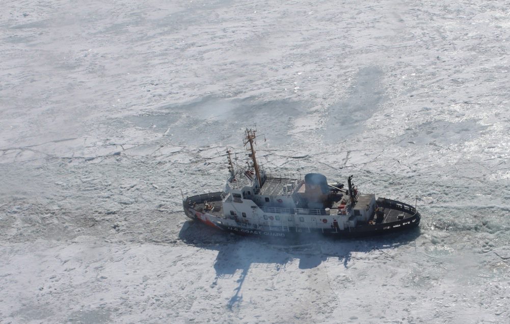
The crew of Coast Guard Cutter Neah Bay, a 140-foot ice-breaking tug homported in Cleveland, breaks through the ice in the St. Clair River, Feb. 26, 2014. U.S. Coast Guard Photo
Persistent cold temperatures in the Midwest this winter have resulted in historic ice coverage on the Great Lakes with many almost completely frozen over, according to new data from The Great Lakes Environmental Research Laboratory (GLERL).
The latest data from GLERL shows that as of mid-February, the ice coverage on the Great Lakes stood at 88 percent, by far the greatest percentage seen in the last 30 years. The last time ice cover was even close to this extent was in 1996 when maximum seasonal ice cover was approximately 82 percent. The record was set in 1979 when nearly 95% of the Great Lakes were frozen.
PHOTOS: Polar Vortex Grips Great Lakes Shipping
The map below shows ice coverage on the Great Lakes on February 13, where shades of blue indicate ice concentration, with the darkest shade of blue indicating areas where 0-10 percent of the water’s surface is frozen and white indicating areas where the water is entirely frozen over.
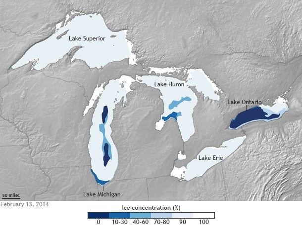
As you can see, Lakes Superior, Erie, Huron, and St. Clair were 90-100 percent ice covered, while Lakes Michigan and Ontario were 82 percent and 43 percent ice covered, respectively. Overall, 88 percent of the Great Lakes were frozen on this date—the most extensive total ice coverage observed so far this winter, the GLERL said.
It is estimated that maximum ice cover on the lower lakes normally occurs between mid-February and end of February, while the maximum on the upper lakes normally occurs between the end of February and early March.
According to the Midwest Regional Climate Center, average temperatures were below normal across the region during the second week of February. If cold temperatures persist, the MRCC reports, “it is possible that the Great Lakes could approach the record-setting year of 1979, which recorded 94.7 percent maximum ice coverage.”
The ice coverage and winter weather have taken a toll on Great Lakes shipping this season, but has had some benefits such as allowing access into typically inaccessible ice caves near Lake Superior.
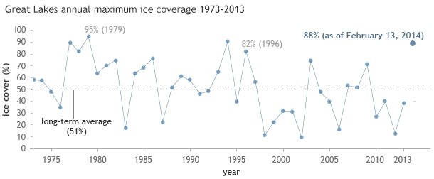
Map and graph by NOAA Climate.gov, based on data provided by the U.S. Naval Ice Center.

 Join The Club


