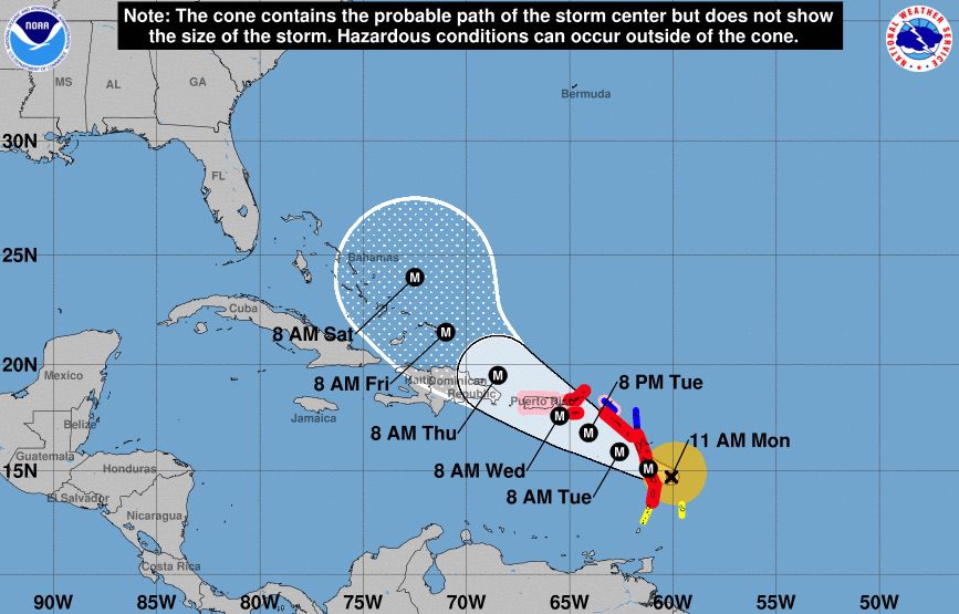
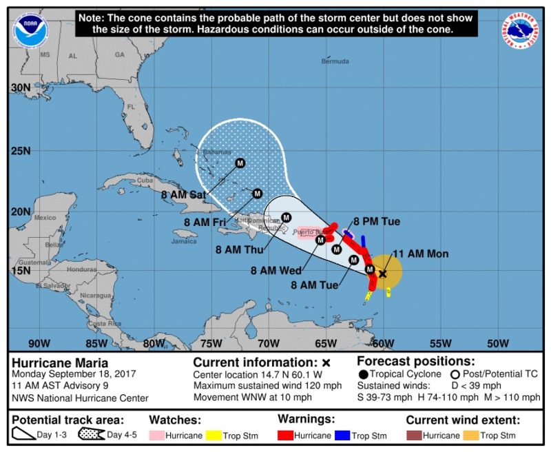
Update:Hurricane Maria has been upgraded to a Category 2 hurricane with maximum sustained winds of 120 m.p.h. as it sets its aim for Puerto Rico. For the latest forecasts and watches and warnings from NOAA, check out http://www.nhc.noaa.gov/.
(Reuters) Tropical Storm Maria is likely to reach hurricane strength on Sunday, prompting U.S. weather forecasters to issue warnings and watches for a string of Caribbean islands, some of which were battered by powerful Hurricane Irma less than two weeks before.
Maria was about 405 miles (655 km) southeast of the Leeward islands with maximum sustained winds of 65 (100 km) per hour at 2 p.m. EDT (1800 GMT), the U.S. National Hurricane Center said.
“Strengthening is forecast during the next 48 hours and Maria is expected to become a hurricane later today or tonight,” the forecaster said.
The hurricane center warned that the U.S. and British Virgin Islands and the U.S. territory of Puerto Rico should monitor the storm’s progress. The government of Puerto Rico has already begun preparations for Maria, which is expected to make landfall there on Tuesday, officials said.
The storm is moving west-northwest at about 15 miles (24 km) per hour and is expected to cross the Leeward Islands on Monday night, the NHC said.
Hurricane warnings were in place for the French island of Guadeloupe and for Dominica.
Hurricane conditions also are possible by Tuesday for Antigua, Barbuda, St. Kitts, Nevis, Montserrat, Saba, St. Eustatius, Sint Maarten, St. Martin, St. Barthelemy and Anguilla, the NHC said.
Tropical storm conditions were possible on Monday or Tuesday for St. Lucia, Martinique, Barbados, St. Vincent and the Grenadines.
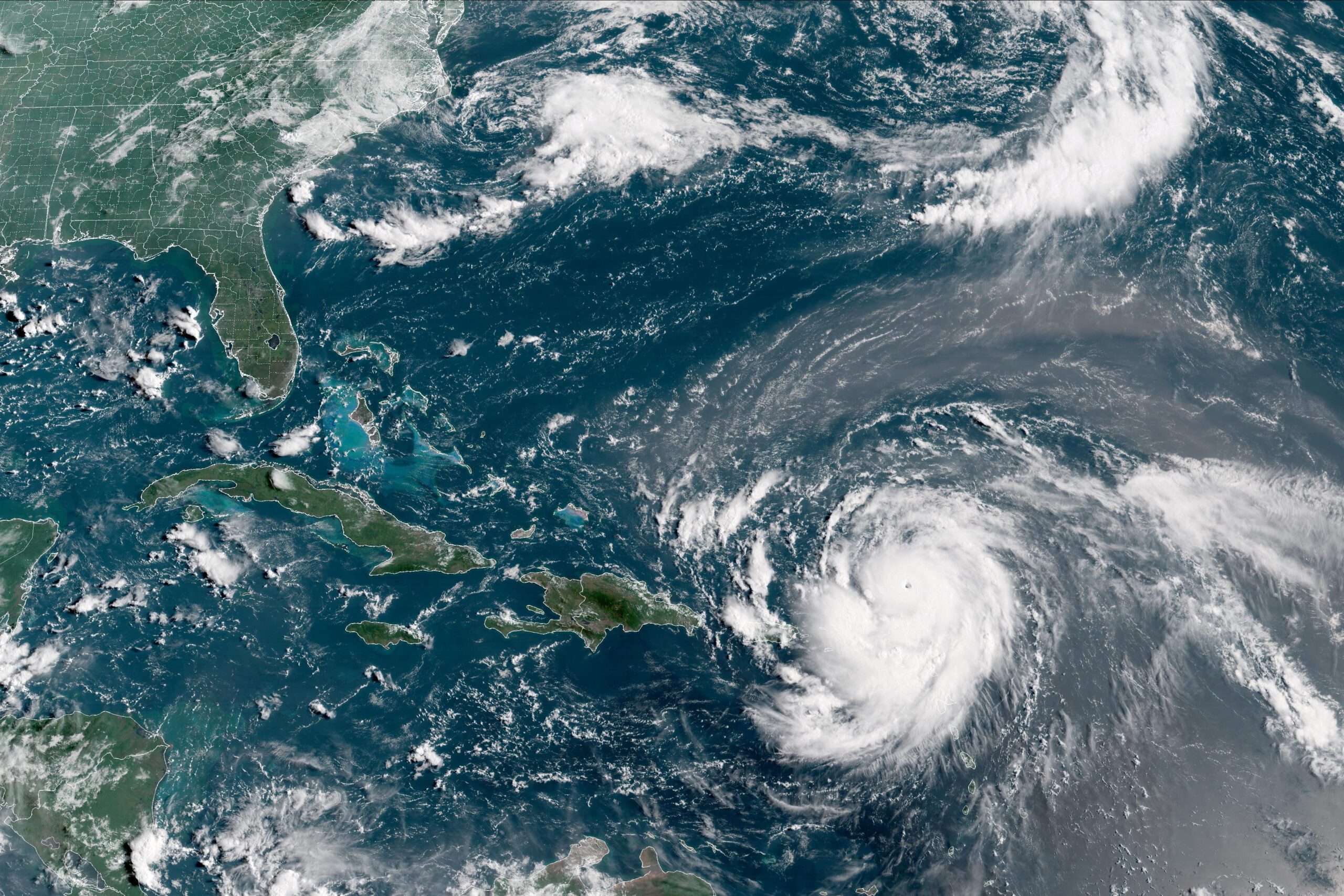
Maria is approaching the eastern Caribbean less than two weeks after Irma hammered the region before overrunning Florida. The powerful Category 4 storm killed at least 84 people, more than half of them in the Caribbean.
A second storm, Hurricane Jose, was in the Atlantic Ocean about 355 miles (575 km) southeast of Cape Hatteras, North Carolina, with top sustained winds of 90 miles (150 km) per hour, the NHC said. Jose is heading north, and its eye is expected to remain off the U.S. East Coast.
By Brian K. Sullivan Aug 16, 2025 (Bloomberg) –Hurricane Erin strengthened on Saturday into a “catastrophic” Category 5 hurricane north of the Caribbean islands, reaching the top of the five-step, Saffir-Simpson...
The National Hurricane Center (NHC) achieved unprecedented accuracy in hurricane track forecasting during the 2024 Atlantic hurricane season, according to a preliminary forecast verification review by the National Weather Service....
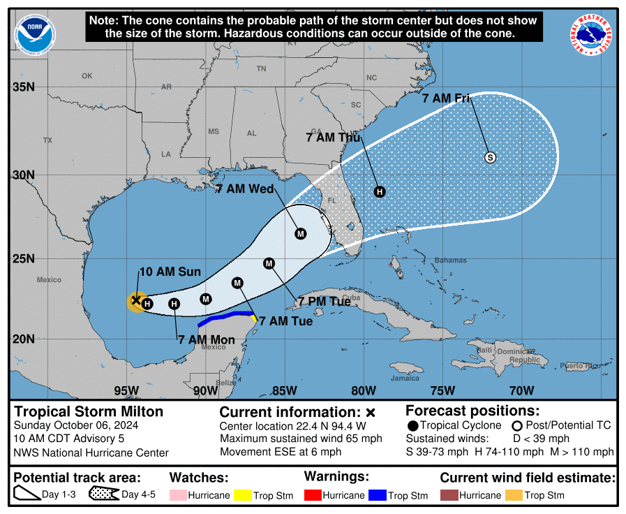
Tropical Storm Milton is rapidly intensifying as it moves across the Gulf of Mexico, prompting major concerns for the west coast of Florida. The National Hurricane Center (NHC) reports that...
October 6, 2024
Total Views: 1989
Get The Industry’s Go-To News
Subscribe to gCaptain Daily and stay informed with the latest global maritime and offshore news
— just like 104,581 professionals
Secure Your Spot
on the gCaptain Crew
Stay informed with the latest maritime and offshore news, delivered daily straight to your inbox
— trusted by our 104,581 members
Your Gateway to the Maritime World!
Essential news coupled with the finest maritime content sourced from across the globe.

 Join The Club