
 Join The Club


Bilge Dump CSI: AIS Helps ID Vessel Responsible for Oil Slick Off Angola
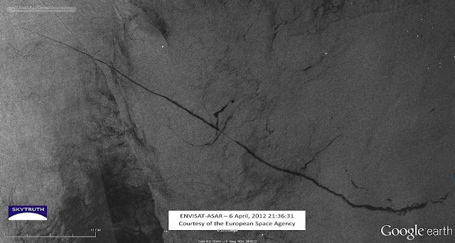
Radar satellite image showing a 92 mile long bilge-dump slick, taken on April 6, 2012. Envisat ASAR image courtesy European Space Agency.
On April 6th, satellite-image-monitoring-environmental group SkyTruth identified a 92-mile slick off Congo and Angola captured in the above photo that was likely the result of a discharge of oily bilge water from a ship. Now, after a thorough investigation worthy of it’s own CSI episode to find the perp, SkyTruth believes it has identified just who is responsible for the release of the oily bilge waste.
Here, SkyTruth tells us just how they cracked the case and scroll all the way down to find out ‘whodunnit’:
In the ASAR satellite radar image, we can determine the exact time and date of the event, the coordinates of the start and end point of the slick, the length of the slick, and the heading of the vessel:

SpaceQuest builds satellites that intercept Automatic Identification System (AIS) data broadcast by vessels at sea. SpaceQuest gave us AIS data for the region spanning a 24-hour period, enabling us to identify vessels that were operating in the area around the same time the radar image was taken. After doing some simple math, we had enough information to pinpoint the likely culprit.

AIS data for a vessel 39 miles northwest from the observed location of the ship gave a heading of 293.8° and a speed of 15 knots (17.3 mph). This AIS information was broadcast 2.25 hours after the radar image was taken. If the ship traveled for 2.25 hours at 17.3 mph, then the ship traveled 38.925 miles, very close to the measured distance between the observed location and the AIS position.

The heading of the ship was reported by AIS to be 293.8°, only 1.1° off from the measured heading of 294.9°. I also calculated where the vessel should be, had it been traveling for 2.25 hours at the AIS-recorded heading from the location observed on the satellite imagery. The ship would have ended up only 0.79 miles from the AIS-recorded location. No other vessels appear anywhere near this location on either the radar image, or the AIS data, making the Dona Liberta a likely culprit for this bilge dumping.

But a ‘good idea’ of who dumped this material really isn’t good enough. After checking back with SpaceQuest on our findings, they supplemented our data with a compilation of the perp’s AIS data for the previous 24 hours. From that, we were able to determine more about the trajectory of this vessel:

The observed location of the vessel in the radar satellite image was bracketed by two AIS data points, so there was more information available to cross reference with our current suspect. By comparing the time of each AIS point, with the time of the ASAR image, as well as the distance between them, the rate of travel was confirmed:

The distance between the eastern AIS position to the observed location (yellow line) is 16.9 miles, and the vessel’s speed according to AIS was 15.1knots (17.377 mph), giving a travel time of 58.4 minutes. The actual time difference between the radar image and the AIS broadcast is 54 minutes. On the other side, the distance between the western AIS point and the observed location (pink line) is 9.66 miles, with the vessel speed at 15.2 knots (17.49 mph), implying a travel time of 33.1 minutes compared with the actual time difference of 36 minutes. These measurements are not exact but are very close, with no other vessels in the vicinity that could be confused with the suspected vessel.
After this thorough investigation, SkyTruth has revealed the perpetrator as…. the Dona Liberta, a refrigerated cargo ship owned by NaviFruit LTD.

Updated: June 27, 2012 (Originally published June 22, 2012)
Subscribe for Daily Maritime Insights
Sign up for gCaptain’s newsletter and never miss an update
— trusted by our 107,427 members
Stay Informed. Stay Connected.
Get The Daily Insights That Power Maritime Professionals Worldwide
Essential maritime and offshore news, insights, and updates delivered daily straight to your inbox
— trusted by our 107,427 members
Have a news tip? Let us know.
Get The Industry’s Go-To News
Subscribe to gCaptain Daily and stay informed with the latest global maritime and offshore news


