Royal Caribbean’s Anthem of the Seas in fairer weather. Photo credit: Royal Caribbean
The Anthem of the Seas departed Bayonne, New Jersey last Saturday with about 4,500 guests and 1,600 crewmembers for what was scheduled to be a 7-day roundtrip cruise to the Bahamas. But during Sunday the vessel was sailing southward to a scheduled port call at Port Canaveral, Florida when it encountered a large, hurricane-force storm off of Cape Hatteras, North Carolina, forcing the Captain to lock down the ship as they rode it out.
Although Royal Caribbean has apologized to guests and crew and promised to strengthen its storm avoidance policy, the company still maintains that the weather last Sunday “far exceeded” forecasts. Let’s just take a look:
Weather Forecasts
As early as Wednesday afternoon (Feb 3), the NOAA 96 hour forecast chart was showing a rapidly deepening low forming east-southeast of Cape Hatteras early Sunday(Feb 7) reaching storm force by early Monday morning.
NOAA OPC 96 Hour Surface Forecast for Sunday morning 7 Feb 2016
Updated forecasts late Friday night indicated that storm force winds likely would occur closer to the North Carolina coast than the earlier forecast by late Sunday with conditions reaching hurricane force winds by early Monday.
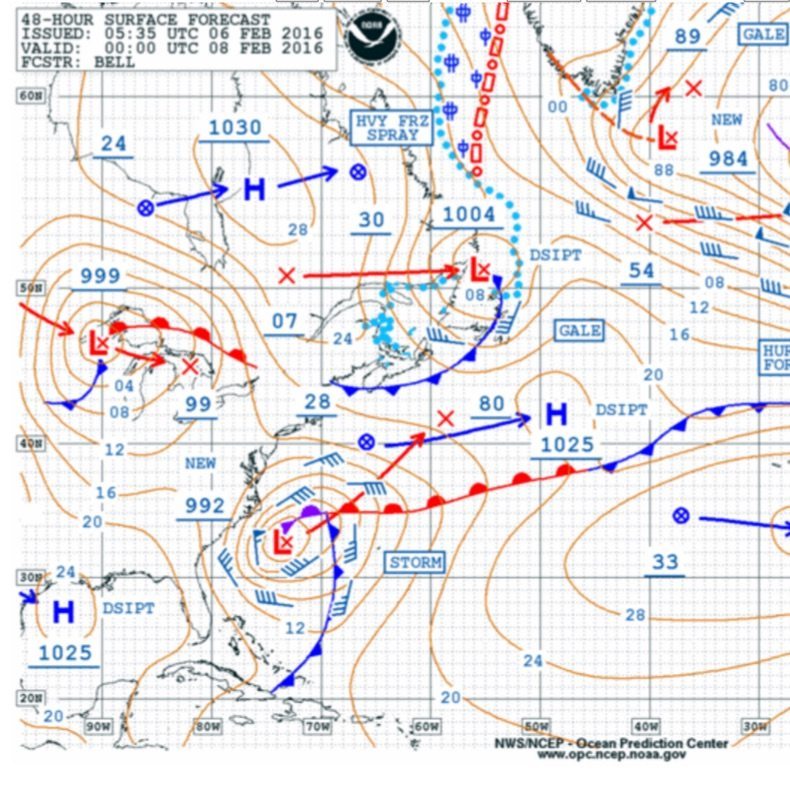
By Saturday evening the updated NOAA Forecast chart issued just after midnight Saturday night indicated hurricane force winds with waves to 24 feet should be expected just off the Carolina coast by Sunday evening instead of early Monday morning.
NOAA OPC 48 hour Surface Forecast for Sunday Evening
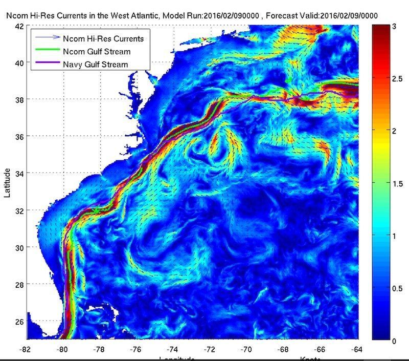
Role of the Gulfstream
The warm waters of the Gulfstream move up the US Coast from the Florida Straits and pass close to Cape Hatteras before turning eastward. The warm water in conjunction with cold air moving off the East Coast during winter often provides the dynamics to produce rapidly deepening storms off the US East Coast. In addition, when strong winds blow over strong currents moving in the opposite direction waves tend to shorten in length and increase in height. Near the north wall of the Gulfstream this is a well known phenomena where there is a higher risk for rouge waves during these conditions.
NOAA Gulf Stream Forecast
Vessel Track
As of this writing, I have not seen the actual position reports of the Anthem of the Seas so it would be difficult to say what track options were available to the master or what decisions were made. Given that the early forecasts suggested storm force conditions with the heaviest weather developing overnight Sunday into early Monday, perhaps the voyage plan might have taken the vessel clear of this area before the onset of the worse conditions.
Forecast updates issued late Friday night indicated that the area of storm force winds would likely occur closer to the coastline but the heaviest conditions still developing Sunday night and early Monday. By late Saturday night, the voyage was already underway when the updated forecast indicated that the storm would produce hurricane force winds with seas over 20 feet.
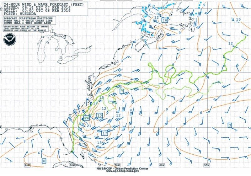
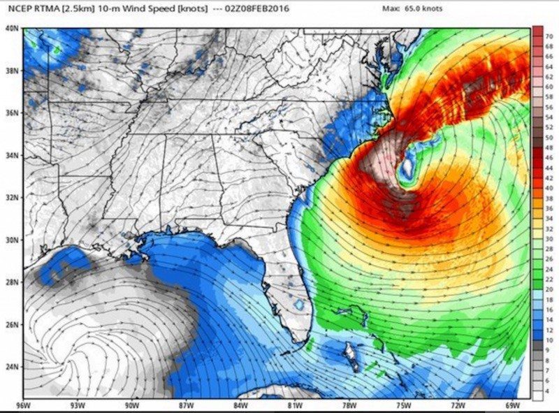
The storm did, in fact, deepen rapidly during Sunday with hurricane force winds and waves to over 30 feet developing by early Sunday evening just off the North Carolina Coast when the vessel encountered severe weather conditions near where the Gulfstream comes closest to the North Carolina coast.
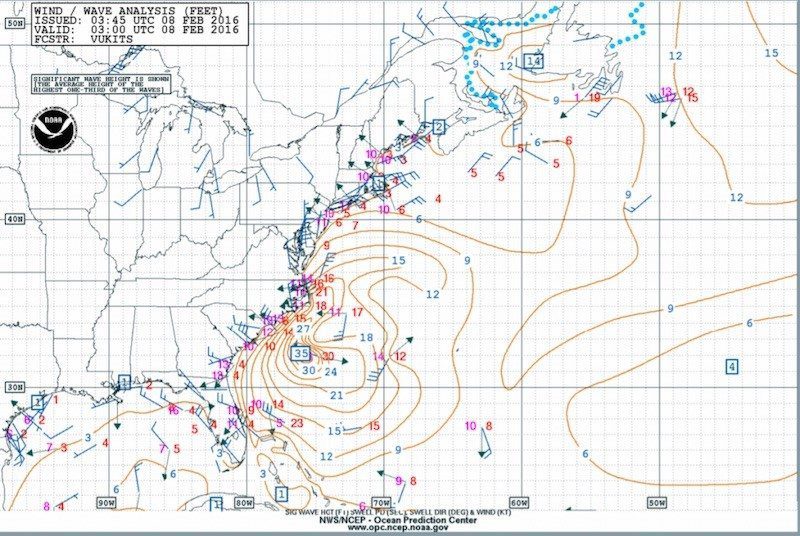
NOAA 24hr wind wave forecast for Sunday eveningHi Res 10 meter winds 9pm Sunday 7 Feb 2016 Image credit weatherbell.comNOAA Wind and Wave Analysis 10PM Sunday 7 Feb 2016
CAIRO, March 2 (Reuters) – The Houthi Transport Ministry in Yemen said on Saturday there had been a “glitch” in undersea communication cables in the Red Sea as a result of actions...
by Captain John Konrad (gCaptain) In the current American labor landscape, the stark contrast between the assertive strides of transportation unions and the maritime sector’s unique labor challenges is striking....
By Mikhail Flores MANILA, Dec 2 (Reuters) – Evacuations were under way in the Philippines after a quake of at least magnitude 7.5 struck the southern region of Mindanao on Saturday night,...
December 2, 2023
Total Views: 2164
Why Join the gCaptain Club?
Access exclusive insights, engage in vibrant discussions, and gain perspectives from our CEO.
This website uses cookies to improve your experience while you navigate through the website. Out of these, the cookies that are categorized as necessary are stored on your browser as they are essential for the working of basic functionalities of the website. We also use third-party cookies that help us analyze and understand how you use this website. These cookies will be stored in your browser only with your consent. You also have the option to opt-out of these cookies. But opting out of some of these cookies may affect your browsing experience.
Necessary cookies are absolutely essential for the website to function properly. This category only includes cookies that ensures basic functionalities and security features of the website. These cookies do not store any personal information.
Any cookies that may not be particularly necessary for the website to function and is used specifically to collect user personal data via analytics, ads, other embedded contents are termed as non-necessary cookies. It is mandatory to procure user consent prior to running these cookies on your website.

 Join The Club


![A screengrab of a map showing an earthquake Mindanao, Philippines on Dec 2, 2023. (Image: US Geological Survey [USGS])](https://gcaptain.com/wp-content/uploads/2023/12/Screenshot-2023-12-02-at-10.45.17-AM-copy.png.webp)


