From the gCaptain archives…
Here at gCaptain, we are a big fan of maps and when you came across this one, we couldn’t help but to post here on the blog.
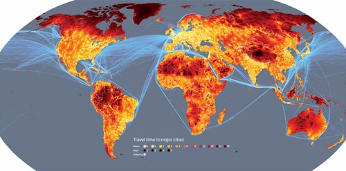
The above map, created by researchers at the European Commission’s Joint Research Centre in Ispra, Italy, and the World Bank, plots the remotest places on Earth (shown in darker shades of red).
The maps are based on a model which calculated how long it would take to travel to the nearest city of 50,000 or more people by land or water. The model combines information on terrain and access to road, rail and river networks. It also considers how factors such as altitude, steepness of terrain and hold-ups like border crossings slow travel.
While the map is pretty typical to what one would expect, there are some unexpected surprises.
In the Amazon, for example, extensive river networks and an increasing number of roads mean that only 20 per cent of the land is more than two days from a city – around the same proportion as Canada’s Quebec province.
You can read the full article at NewScientist.com and be sure to let us know what struck you in the comments section. Of course, click on the map above for a larger image.
Updated: February 5, 2026 (Originally published October 30, 2010)
Editorial Standards · Corrections · About gCaptain

 Join The Club


