Image courtesy National Hurricane Center

By Jane Sutton
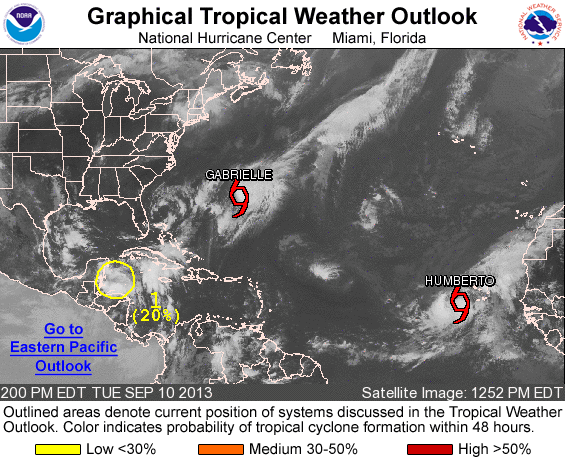
MIAMI, Sept 10 (Reuters) – Tropical Storm Gabrielle regenerated and bore down on Bermuda on Tuesday while Tropical Storm Humberto strengthened to the verge of becoming the season’s first Atlantic hurricane, forecasters said.
The burst of activity came right on schedule as the Atlantic-Caribbean storm season hit its traditional peak.
Gabrielle was about 30 miles (45 km) south-southwest of Bermuda and forecasters at the U.S. National Hurricane Center said it was expected to pass over the mid-Atlantic island later Tuesday.
Its top winds had jumped to 60 mph (95 kph), up from 40 mph (65 kph) earlier, and a slight further increase in strength seemed likely, the forecasters said.
They said Bermuda was already being lashed by rough seas, heavy wind gusts and rain and several flights to the island had been canceled in anticipation of the storm.
The affluent British territory has strict building codes and tends to withstand tropical storms without major damage.
Gabrielle first formed last week in the northeastern Caribbean, soaking Puerto Rico as it crossed into the Atlantic. It fizzled quickly, but regrouped during the weekend and became a tropical storm again on Tuesday.
On its current track, after dusting Bermuda, Gabrielle should curve north toward Nova Scotia and Newfoundland, the hurricane center said. It was expected to remain a tropical storm until it approached Newfoundland on Saturday.
Tropical Storm Humberto formed on Monday in the eastern Atlantic near the African coast and brushed by the southern Cape Verde Islands. It was about 245 miles (400 km) west of Cape Verde on Tuesday afternoon, headed northwest over open waters and posing no threat to land.
Humberto had top winds of 70 mph (110 kph) and was expected to cross the 74 mph (119 kph) threshold to become a hurricane later Tuesday or early Wednesday.
It is the eighth tropical storm of the Atlantic-Caribbean hurricane season, which runs from June 1 to Nov. 30 and historically peaks on Sept. 10. But it would be the first this year to reach hurricane strength.
The first hurricane of the season usually forms by Aug. 10.
Since the dawn of the satellite era in the mid-1960s, the latest date for the first hurricane to arrive was set in 2002 when Hurricane Gustav made its debut on Sept. 11.
If Humberto reaches hurricane status after 8 a.m. EDT (1200 GMT) on Wednesday, it will replace Gustav as the modern-day record holder, the forecasters in Miami said.
© 2013 Thomson Reuters.
Editorial Standards · Corrections · About gCaptain
This article contains reporting from Reuters, published under license.

 Join The Club


![Top Hurricane Tracking Sites [Ranked]](https://gcaptain.com/wp-content/uploads/2012/08/699900main_sandy_360.jpeg)


