
 Join The Club


NOAA
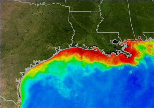
Is The Gulf of Mexico ‘Dead Zone’ Widening?
A team of NOAA-supported scientists is predicting that this year’s Gulf of Mexico hypoxic zone could range from a low of approximately 1,197 square miles
A team of NOAA-supported scientists is predicting that this year’s Gulf of Mexico hypoxic zone could range from a low of approximately 1,197 square miles
![Marinette Marine Launches the Reuben Lasker Research Ship [VIDEO]](https://gcaptain.com/wp-content/uploads/2012/06/Picture-64.jpg)
This past weekend, Marinette Marine Corporation (MMC), a Fincantieri company, launched the Reuben Lasker, a fisheries survey vessel that the Wisconsin
When the first hurricane emerges from the Atlantic Ocean or Gulf of Mexico this season, NOAA will use a new statistical model to help predict the start of the

[vimeo]http://vimeo.com/42291773[/vimeo] Video courtesy of NOAA Okeanos Explorer Program In crystal clear high definition video, NOAA’s Little
By Doug Helton, National Oceanic and Atmospheric Administration (NOAA) For the past year, we at NOAA and the U.S. Coast Guard have been studying the possible

In addition to authors Vicki Loe and CJ Beegle-Krause, Charlie Henry, Doug Helton, and Amy Merten contributed to this post, via NOAA Response and Restoration
Mariners along the U.S. east coast can download a new iPad/iPhone application that warns them when they enter areas of high risk of collision with critically
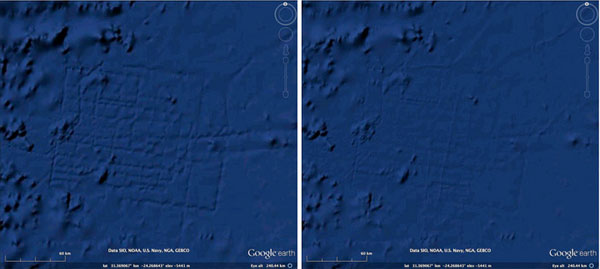
The National Ocean Service, has a minor problem they wish to address. While ‘navigating’ the ocean floor in Google Earth, countless amateur
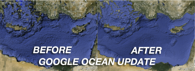
[dropcap]I[/dropcap]n the three years since Google earthexpanded its reach into the ocean the company has focused with enthusiasm on building great
The U.S. Integrated Ocean Observing System, or IOOS®, is a vast, coordinated network of people and technology working together to deliver data on our
By Captain Patrick Donovan, R/V Thomas G. Thompson, University of Washington As mariners we encounter them all the time… a yellow buoy, a white ship,
NOAA Ship Rainier has begun a month-long survey of the sea floor near Alaska’s Prince of Wales Island as part of a multi-year effort to update nautical
By Arian Campo-Flores, Valerie Bauerlein and Mike Esterl, Dow Jones & Co Hurricane Irene thrashed the Bahamas early Thursday, with widespread damage

By John J. Miller Tropical Storm Emily petered out over Cuba last week, but the National Oceanic and Atmospheric Administration warns of “high hurricane
Photo By Rob Almeida, Copyright 2011 Remarks by NOAA Administrator Dr. Jane Lubchenco during Capitol Hill Oceans Week June 7, 2011 Good morning everyone! Let
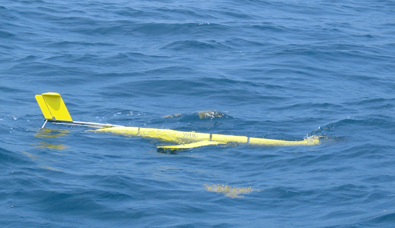
For the last few weeks, in the Ionian Sea to the southeast of Sicily, three gliders participated for the first time in an anti-submarine warfare exercise.
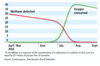
Bacteria made quick work of the tons of methane that billowed into the Gulf of Mexico along with oil from the Deepwater Horizon blowout, clearing the natural
The following article by CDR Michael Hendersen, Navigation Manager NOAA was originally published in the December 2010 edition of CAMM , Council Of American
For the first time since its inception on December 9, 2008, NOAA has issued notices of violations against seven vessels that have allegedly failed to meet the
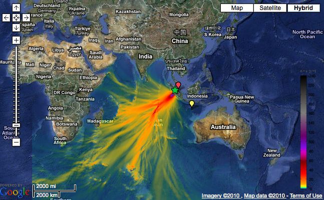
Click image for interactive map Tsunami Event – October 25, 2010 Mentawai, Indonesia The Indonesia tsunami event was generated by a Mw 7.7 earthquake
Join the 105,953 members that receive our newsletter.
Have a news tip? Let us know.

Maritime and offshore news trusted by our 105,953 members delivered daily straight to your inbox.


Essential news coupled with the finest maritime content sourced from across the globe.
Sign Up
