.
(Bloomberg) — Hurricane Sandy was barreling northward along the U.S. East Coast as forecasters warned it would converge with two other systems to create a superstorm threatening to bring high winds, rain and a tidal surge that may inundate Mid-Atlantic and Northeast coastal areas.
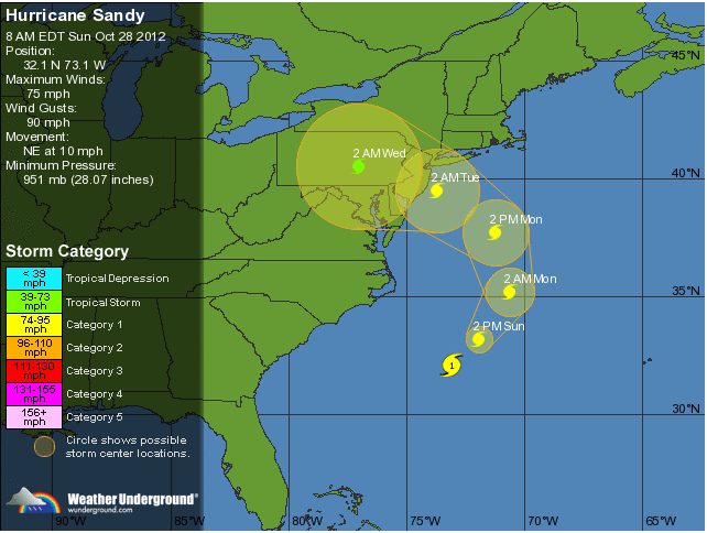
Sandy, which killed as many as 58 people as it moved through the Caribbean, is predicted to make landfall late tomorrow or early Oct. 30. It is on track to come ashore in southern New Jersey before turning inland, according to the National Hurricane Center’s three-day forecast.
Authorities were poised to begin evacuations, utilities were preparing for power failures that may affect millions of people, and airlines made arrangements to cancel flights and move planes. The cyclone that will grow out of Sandy and two storms rushing eastward across the U.S. has been dubbed “Frankenstorm” by the National Weather Service.
“There is going to be a lot of rain and wind damage,” said Dan Pydynowski, a meteorologist with AccuWeather Inc., in a telephone interview. “This is going to be a much larger, more widespread storm than Hurricane Irene.”
The National Guard and Air Force put as many as 45,000 personnel in seven states on alert for possible duty in response to the storm, according to George Little, a spokesman for the Defense Department in Washington.
‘Days of Impacts’
“Because of the large size of the system and the slow motion, it’s going to be a long-lasting event, two to three days of impacts for a lot of people,” said James Franklin, branch chief at the hurricane center in Miami. “The kinds of things we are looking at ultimately would be wind damage, widespread power outages, heavy rainfall, inland flooding and again, somebody is going to get a significant surge event out of this.”
Louis Uccellini, director of the National Centers for Environmental Prediction, said Sandy’s winds will be felt as far away from the coast as Ohio and Michigan, and the system could be comparable to 1991’s so-called perfect storm. That nor’easter, in October of that year, eventually formed Hurricane Grace, and was chronicled in the best-selling book, “The Perfect Storm,” by Sebastian Junger.
Casinos Shutting
Sandy’s maximum sustained winds remained unchanged at 75 miles (120 kilometers) per hour, the hurricane center said today in an advisory before 8 a.m. New York time. It was centered about 260 miles southeast of Cape Hatteras, North Carolina, and about 395 miles south of New York, moving northeast at 10 mph. The storm is expected to have near-hurricane-force winds as it approaches the mid-Atlantic coast tomorrow night, the Miami- based center said.
New Jersey Governor Chris Christie ordered that the state’s barrier islands and casinos in Atlantic City be evacuated by 4 p.m. today. The governor asked residents to pay heed to the warnings and “be prepared for the worst here.”
In New York City, plans were being made today to start closing subway, bus and commuter-train systems at 7 p.m. today. The Metropolitan Transportation Authority, the city’s subway system, serves 8.5 million riders daily.
The storm may dump as much as 12 inches (30 centimeters) of rain on parts of the Northeast, the hurricane center said. The damage will be spread across a wider area than that left by a typical hurricane, the NHC’s Franklin said.
“Our track forecast error is on the order of 150 to 200 miles,” Franklin said. “We cannot be precise at this stage.”
Storm Surge
Franklin said the storm surge, in which ocean water is pushed ashore, will hit a larger area than Hurricane Irene last year. The storm also will be striking two days after the full moon, when tides are at their highest.
“The lunar tides, this is a dangerous period,” Uccellini said. “And with the slow movement of the storm you can go through two or three tidal cycles, which also contributes to the potential impact of this event.”
The National Hurricane Center said water may rise as much as 8 feet (2.4 meters) above ground with the storm surge from Ocean City, Maryland, to the Connecticut/Rhode Island border and 11 feet in Long Island Sound and Raritan Bay.
Uccellini said there is the potential for at least 12 inches of snow in West Virginia and lesser amounts in Pennsylvania and eastern Ohio.
The hurricane center’s five-day prediction shows the system turning north over Pennsylvania at tropical-storm strength before weakening as it crosses into New York State, over Lake Ontario and into Canada.
Power Failures
Power may be out as long as 10 days in some areas, according to a statement from the Edison Electric Institute, an industry trade group in Washington.
The storm may cause hardship for thousands, especially those that get hit by the snow and also lose power, said Mark Hoekzema, chief meteorologist at Earth Networks in Germantown, Maryland.
“Are you ready to potentially be without power for a week?” Hoekzema said by telephone. The windstorm that hit the Washington area in June “showed us how long it can take to get 3-plus-million people back, and in the Northeast Corridor, you have even more people,” he said.
Discussions are under way to evacuate parts of New York City and close subways if necessary, said Jerome Hauer, New York State’s homeland security commissioner.
Worst-Case Scenario
“The worst-case scenario is that the storm hits in the mid-Jersey area, with the right-sided winds,” Hauer said in an interview. “That forces water in the ocean into New York Harbor and we get significant flooding in New York City, particularly in lower Manhattan, Brooklyn and Queens.”
CoreLogic Inc., which tracks real-estate information, said about 284,000 homes in seven U.S. states from Virginia to Massachusetts valued at almost $88 billion are at risk for possible storm-surge damage.
The system crossed Jamaica Oct. 24 and Cuba on Oct. 25, tracking north across the central Bahamas.
Sandy may have caused $1.4 billion to $2.4 billion in damage on Cuba, Jamaica and the Bahamas, according to Air Worldwide, a catastrophe-modeling firm in Boston.
– Brian K. Sullivan and Dan Hart, Copyright 2012 Bloomberg.
Unlock Exclusive Insights Today!
Join the gCaptain Club for curated content, insider opinions, and vibrant community discussions.

 Join The Club