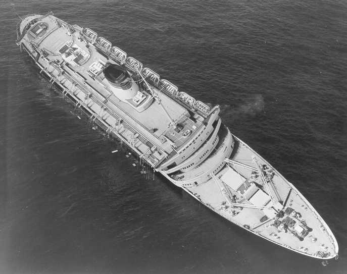
The Andrea Doria before capsizing and sinking in the Atlantic Ocean, July 26, 1956. U.S. Coast Guard Photo
For the first time ever, a team of underwater explorers have captured detailed close-up sonar images of the legendary Andrea Doria nearly 60 years after its sinking off the coast of Nantucket.
The sonar images are being collected by a team from OceanGate, an ocean exploration company, which has launched the first manned submersible dives to the wreck in more than 20 years.
The Italian passenger liner sank with the loss of 51 lives in 1956 about 50 miles from Nantucket after colliding with the Swedish cruise liner MS Stockholm. The 697-foot-long wreck is often referred to as the “Mt. Everest of scuba diving” due its location and depth, which 1t a 240-feet is just out of reach for divers on compressed air. In fact, over the years a total of 16 divers have died trying to reach the wreck.
“Five times more people have been to the top of Mt. Everest than have seen the Andrea Doria wreck site, so this expedition was a rare opportunity for our crew – all while expanding our knowledge of the ocean,” said Stockton Rush, OceanGate’s Chief Executive Officer. “Using our five-person Cyclops 1 submersible, we were able to view the Andrea Doria area for nearly four hours, which is more than 10 times longer than scuba divers can.”
The goal of the dives is to use multi-beam sonar to survey the wreck, then digitally assemble scans into a 3-D model to help illustrate the full scope of the wreck and document its current condition.
OceanGate says in that first expedition, the team able to do 17 scans of the bow before foggy conditions and rough seas forced them to stop.
“Given the conditions, we got as much time on the wreck as we could,” Rush said. “We have great respect for harsh ocean conditions, and for the history of this infamous wreck, so ensuring the safety of our crew is always our top priority.
But the recent expedition was the first of many more dives to come.
“We’ve always planned to revisit the Andrea Doria regularly to continue an ongoing mapping process, and what we captured will certainly serve as a benchmark for what we capture on future expeditions.”
Unfortunately for historians and underwater archeologists, the initial sonar images have suggested that the shipwreck may be in worse condition that previously thought, with the bow of the vessel nearly broken off.
The AP has that story:
Unlock Exclusive Insights Today!
Join the gCaptain Club for curated content, insider opinions, and vibrant community discussions.

 Join The Club